
The London International Airport is an international airport located in London, Ontario, Canada. It is located 5 nautical miles northeast of the city of London, Ontario and is classified as an airport of entry by Nav Canada. In 2023, the airport was listed as the 17th busiest airport in Canada in terms of aircraft movements with 102,122 flights. The airport posted a record 683,000 travelers in 2019 and 332,447 passengers in 2023. It provides services for cargo airlines and year-round flights with Air Canada Express and WestJet.

The Bass Islands consist primarily of Rapa Iti and Marotiri. They are usually considered to be the southernmost of the Austral Islands, although this classification is more one of geographic and political expediency than because of similarities between them and the rest of the Austral Islands. The Bass Islands, lying several degrees outside the tropics, are the southernmost islands in French Polynesia. Culturally, the Bass Islands appear to have been colonized about the same time as Tahiti and the Marquesas, and the culture and language (Rapan) appear to have diverged about the same time as well, indicating that they developed in relative isolation almost from the time of first settlement.
Santa Fe is a municipality in the Honduran department of Colón.

Medicine Hat Airport is located 2 nautical miles southwest of Medicine Hat, Alberta, Canada. WestJet Link services the airport daily from Calgary.

Buse Lake Protected Area, informally known as Buse Lake Provincial Park, is a provincial park in British Columbia, Canada, 23 km east-southeast of Kamloops near Monte Creek. It was created in 2000 as part of the outcome of the Kamloops Landuse and Resource Management Plan (KLRMP) and is 228 hectares in size.
Gold Muchalat Provincial Park is a provincial park in British Columbia, Canada, located between the Gold and Muchalat Rivers.
Malaspina Provincial Park is a provincial park in British Columbia, Canada, located on the northeast side of the Malaspina Peninsula facing Desolation Sound in the northernmost area of that province's Sunshine Coast region.
Ruth Lake Provincial Park is a provincial park in British Columbia, Canada, located northeast of 100 Mile House.
Shuswap Lake Marine Provincial Park is a provincial park in British Columbia, Canada, comprising 894 ha. The Park has a variety of amenities including boat launch ramps, picnic areas, and 27 campsites around the perimeter of Shuswap Lake. The lake's name and that of the surrounding Shuswap Country is from the Shuswap people (Secwepemc), the most northern of the Salishan speaking people.
Ford Motor Company operates several proving grounds worldwide, for development and validation testing of new vehicles.
The Carrizo Impact Area was used by the United States Navy as an air-to-ground bombing range during World War II and the Korean War. It is in the Anza-Borrego desert in south central California and covers about 45 square miles (120 km2). The majority of the range is in Anza-Borrego Desert State Park and about a third is owned by the United States Bureau of Land Management, including the Fish Creek Mountains Wilderness. The Navy currently only owns about 2 percent of the land and about 5 percent is privately owned. There are no structures or habitations within a 20-mile (32 km) radius of the site.

Laakso is a neighbourhood in Helsinki, Finland. Its borders are defined by the streets of Mannerheimintie and Nordenskiöldinkatu and the Helsinki Central Park. The neighbourhood is bordered by Töölö in the south, Meilahti in the southwest, Ruskeasuo in the north and Länsi-Pasila in the east.

The Gwa'sala-Nakwaxda'xw Nations are an amalgamation of two Kwakwaka'wakw peoples in a band government based on northern Vancouver Island in British Columbia, whose main reserve community is near the town of Port Hardy in the Queen Charlotte Strait region of the Central Coast region of British Columbia, Canada. In the 1960s the Gwa'sala (Gwaʼsa̱la), the 'Nakwaxda'xw (ʼNakʼwaxdaʼx̱w) and the Kwakiutl peoples were amalgamated. Later the Gwa'sala-'Nakwaxda'xw Nations and the Kwakiutl First Nation separated into the two groups that are recognized by the federal government. Gwa'sala-'Nakwaxda'xw Nations were forcibly relocated from their homelands to a location near Port Hardy.

ALSIB was the Soviet Union portion of the Alaska-Siberian air road receiving Lend-Lease aircraft from the Northwest Staging Route. Aircraft manufactured in the United States were flown over this route for World War II combat service on the Eastern Front.

South Twin Island is one of the Apostle Islands in northern Wisconsin, in Lake Superior, and is part of the Apostle Islands National Lakeshore.
Darbha is a town in Bastar district, Chhattisgarh, India.
Kistaram is a town in Sukma district, Chhattisgarh, India.
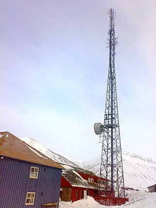
Svalbard Radio is a coast radio station established in 1911 at Finneset in Svalbard, Norway. In 1930, it moved to Skjæringa in Longyearbyen and since 1975 it has been co-located with Svalbard Airport, Longyear. It has been remote-controlled from Bodø Radio since 2006.
Hawthorne School of Aeronautics was a flying school and airport located 5 miles south of Orangeburg, South Carolina. The school was closed in 1945. Currently, the land is being used for non-aviation purposes.

