
Coahuila, formally Coahuila de Zaragoza, officially the Free and Sovereign State of Coahuila de Zaragoza, is one of the 32 states of Mexico.

Tamaulipas, officially the Free and Sovereign State of Tamaulipas, is a state in the northeast region of Mexico; one of the 31 states which, along with Mexico City, comprise the 32 Federal Entities of Mexico. It is divided into 43 municipalities.

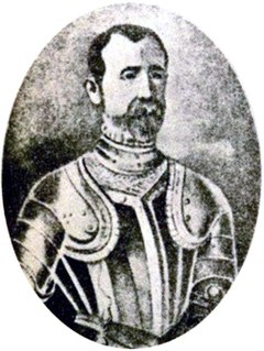
José de Escandón, conde de Sierra was a Spanish Indian-fighter in New Spain and the founder and first governor of the colony of Nuevo Santander, which extended from the Pánuco River in the modern-day Mexican state of Tamaulipas to the Guadalupe River in the modern-day U.S. state of Texas.
Alonso Álvarez de Piñeda was a Spanish conquistador and cartographer who was the first to prove the insularity of the Gulf of Mexico by sailing around its coast. In doing so he created the first map to depict what is now Texas and parts of the Gulf Coast of the United States.

The Sierra Madre Oriental is a mountain range in northeastern Mexico. The Sierra Madre Oriental is part of the American Cordillera, a chain of mountain ranges (cordillera) that consists of an almost continuous sequence of mountain ranges that form the western "backbone" of North America, Central America, South America, and Antarctica.
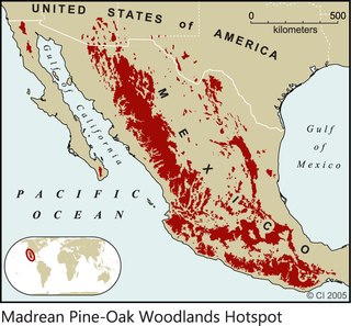
The Madrean pine–oak woodlands are subtropical woodlands found in the mountains of Mexico and the southwestern United States. They are a biogeographic region of the tropical and subtropical coniferous forests and temperate broadleaf and mixed forests biomes, located in North America.
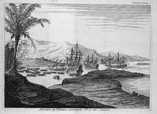
The Pánuco River, also known as the Río de Canoas, is a river in Mexico fed by several tributaries including the Moctezuma River and emptying into the Gulf of Mexico. The river is approximately 510 kilometres (320 mi) long and passes through or borders the states of Mexico, Hidalgo, Querétaro, San Luis Potosí, Tamaulipas, and Veracruz. According to the Atlas of Mexico, it is the fourth-largest river in Mexico by volume of runoff, and forms the sixth-largest river basin in Mexico by area.
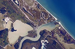
Laguna Madre is a coastal lagoon in Northeastern Mexico. It extends along the coast of Tamaulipas for over 200 km, from the Río Bravo Delta on the north to the mouth of the Soto la Marina River near La Pesca in the south. Laguna Madre is separated from the Gulf of Mexico on the east by a number of barrier islands, including Barra Los Americanos, Barra Jesús María, and Barra Soto la Marina, and is bounded on the west by the Tamaulipan mainland. It is located in the municipalities of Matamoros, San Fernando, and Soto la Marina.
Aldama is a municipality of the northeastern Mexican state of Tamaulipas. According to the census of 2010, the municipality had an area of 3,672 square kilometres (1,418 sq mi) and a population of 29,470, including the town of Aldama with a population of 13,661.

The Central Mexican Plateau, also known as the Mexican Altiplano, is a large arid-to-semiarid plateau that occupies much of northern and central Mexico. Averaging 1,825 m (5,988 ft) above sea level, it extends from the United States border in the north to the Trans-Mexican Volcanic Belt in the south, and is bounded by the Sierra Madre Occidental and Sierra Madre Oriental to the west and east, respectively.

The Veracruz moist forests is a tropical moist broadleaf forests ecoregion in eastern Mexico.

The Sierra Madre Oriental pine–oak forests are a Temperate broadleaf and mixed forests ecoregion of northeastern and Central Mexico, extending into the state of Texas in the United States.

The Tamaulipan mezquital is a deserts and xeric shrublands ecoregion in the southern United States and northeastern Mexico. It covers an area of 141,500 km2 (54,600 sq mi), encompassing a portion of the Gulf Coastal Plain in southern Texas, northern Tamaulipas, northeastern Coahuila, and part of Nuevo León.
Francisco de Garay was a Spanish Basque conquistador. He was a companion to Christopher Columbus on his second voyage to the New World and arrived in Hispaniola in 1493. Here he attracted attention when he encountered a large gold nugget worth four thousand pesos. In 1496, Miguel Diaz and Francisco de Garay found gold nuggets along the Haina River.

The Central Mexican matorral is an ecoregion of the deserts and xeric shrublands biome of central Mexico. It is the southernmost ecoregion of the Nearctic realm.
The Río San Rodrigo is a stream in the state of Coahuila, Mexico, and is a tributary of the Rio Grande.

General Zaragoza is a municipality and town of the northeastern Mexican state of Nuevo León. It is located in the south-eastern part of the state. The town is at 23°58′25″N99°46′23″W. The municipality has a total area of 508 square miles (1,315 km2) and had a population of 5,942 in 2010. Most of the population lives in the town of Zaragoza. The elevation of Zaragoza is 4,520 feet (1,379 m). Zaragoza is bordered by Aramberri, on the south and east by Hidalgo, Tamaulipas, and on the west by Doctor Arroyo.
The Sierra de Tamaulipas is an isolated, semi-tropical mountain range in the Mexican state of Tamaulipas. Its highest point is 1,260 m (4,130 ft). There are no cities or towns in the Sierra and the small population is largely agricultural. The higher elevations of the Sierra have forests of oak and pine, contrasting with the semi-arid brush that dominates at lower altitudes. Several archaeological sites establish that the Sierra de Tamaulipas was the northern outpost of the agricultural Mesoamerican peoples of eastern Mexico.
The Cuenca Alimentadora del Distrito Nacional de Riego 026 Bajo Río San Juan is a protected area in northeastern Mexico. It extends over part of the northern Sierra Madre Occidental, near the cities of Monterrey and Saltillo.
Some of the Geography section of this article was translated from the Spanish Wikipedia article, "Rio Soto La Marina."
