
Senegal, officially the Republic of Senegal, is a country in West Africa. Senegal is bordered by Mauritania in the north, Mali to the east, Guinea to the southeast, and Guinea-Bissau to the southwest. Senegal also borders The Gambia, a country occupying a narrow sliver of land along the banks of the Gambia River, which separates Senegal's southern region of Casamance from the rest of the country. Senegal also shares a maritime border with Cape Verde. Senegal's economic and political capital is Dakar.
New Washington is a census-designated place (CDP) in Clark County, Indiana, United States. As of the 2010 census, the population was 566.

Portland is a city in and the county seat of Jay County, Indiana, United States. The population was 6,223 at the 2010 census, and in 2016 the estimated population was 6,161.

The Makua people, also known as Makhuwa, are a southeastern African ethnic group predominantly found in north Mozambique and southern border provinces of Tanzania such as the Mtwara Region. They are the largest ethnic group in Mozambique, and primarily concentrated in a large region to the north of the Zambezi River.
The Soninke are a West African ethnic group found in eastern Senegal and its capital Dakar, northwestern Mali and Foute Djalon in Guinea, and southern Mauritania. They speak the Soninke language, also called Maraka language, which is one of the Mande languages.
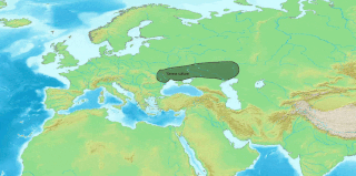
(Eastern) Saka or Sakan is a variety of Eastern Iranian languages, attested from the ancient Buddhist kingdoms of Khotan, Kashgar and Tumshuq in the Tarim Basin, in what is now southern Xinjiang, China. It is a Middle Iranian language. The two kingdoms differed in dialect, their speech known as Khotanese and Tumshuqese.

The Zarma people are an ethnic group predominantly found in westernmost Niger also found in significant numbers in the adjacent areas of Nigeria and Benin, along with smaller numbers in Burkina Faso, Ivory Coast, Ghana, Togo, Cameroon and Burkina Faso.

Hessen Cassel is an unincorporated community in Marion Township, Allen County, Indiana, named for the Landgraviate of Hesse-Kassel in Germany.

Flat Rock is an unincorporated community in Washington Township, Shelby County, in the U.S. state of Indiana.
Harris City is an unincorporated community in Sand Creek Township, Decatur County, Indiana.

Jalapa is an unincorporated community and census-designated place (CDP) in Pleasant Township, Grant County, Indiana, United States. As of the 2010 census it had a population of 171. The site of the Battle of the Mississinewa, fought during the War of 1812, is nearby.
Aroma is an unincorporated community in White River Township, Hamilton County, Indiana.
Tippecanoe is an unincorporated community in Tippecanoe Township, Marshall County, Indiana, United States.
South Peru is a neighborhood within Peru, Indiana in Washington Township, Miami County.
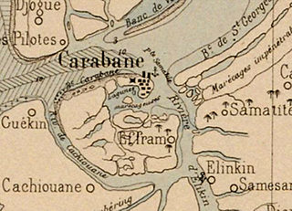
Carabane, also known as Karabane, is an island and a village located in the extreme south-west of Senegal, in the mouth of the Casamance River. This relatively recent geological formation consists of a shoal and alluvium to which soil is added by accumulation in the branches and roots of the mangrove trees which cover most of the island. Along with the rest of Ziguinchor Region, Carabane has a tropical climate, cycling between a dry season and a wet season. The island was once considered an arid location where no useful plants were likely to grow, but it now supports several types of fruit tree, the most common of which are mangos and oranges. Although the nearby Basse Casamance National Park and Kalissaye Avifaunal Reserve have been closed for years because of the Casamance Conflict, Carabane has continued to attract ornithologists interested in its wide variety of birds. Various species of fish are plentiful around the island, but there are very few mammals.

Nunez River or Rio Nuñez is a river in Guinea with its source in the Futa Jallon highlands. It is also known as the Tinguilinta River, after a village along its upper course.
Weaver is an unincorporated community in Liberty Township, Grant County, Indiana. Weaver's first settlers were free people of color who migrated from North Carolina and South Carolina to Grant County in the early 1840s. The neighborhood was originally known as Crossroad; however, it was later renamed Weaver in honor of a prominent family of the community. The rural settlement reached its peak in the late 1800s, when its population reportedly reached 2,000. Many of its residents left the community for higher-paying jobs in larger towns during the Indiana's natural gas boom, but more than 100 families remained in the settlement in the early 1920s. Weaver, as with most of Indiana's black rural settlements, no longer exists as a self-contained community, but Weaver Cemetery remains as a community landmark.
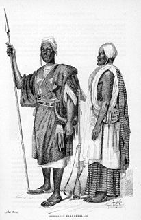
William Spencer Anderson was an American-born Liberian politician and explorer. Originally a barber, Anderson emigrated to Liberia at the age of 20 and within five years had inherited a sugar plantation. He expanded the business and became the largest producer of sugar and coffee in Liberia. Entering politics with the True Whig Party Anderson was selected to be speaker of the House of Representatives. He undertook an expedition to drive a road from Monrovia to Moussodougou in what is now Burkina Faso but he was forced to abandon the attempt. Returning to Monrovia, Anderson successfully negotiated a $500,000 loan for the government from British financiers. However he received criticism for the terms of the loan and was arrested. He was assassinated on 27 September 1872.
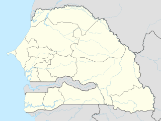
Marsassoum is a small town and seat of the Marsassoum Arrondissement in the Ziguinchor Region of Senegal, roughly 33 kilometres (21 mi) from Ziguinchor. It lies on the bank of the Soungrougrou River. In 2002 it had a population of 6410 people.

