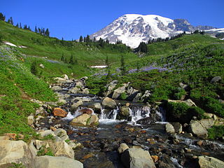
Mount Rainier National Park is an American national park located in southeast Pierce County and northeast Lewis County in Washington state. The park was established on March 2, 1899, as the fourth national park in the United States, preserving 236,381 acres including all of Mount Rainier, a 14,410-foot (4,390 m) stratovolcano. The mountain rises abruptly from the surrounding land with elevations in the park ranging from 1,600 feet to over 14,000 feet (490–4,300 m). The highest point in the Cascade Range, Mount Rainier is surrounded by valleys, waterfalls, subalpine meadows, and 91,000 acres of old-growth forest. More than 25 glaciers descend the flanks of the volcano, which is often shrouded in clouds that dump enormous amounts of rain and snow.

The Wenatchee Mountains are a range of mountains in central Washington State, United States of America. A major subrange of the Cascade Range, extending east 50 miles (80 km) from the Cascade crest, the Wenatchee Mountains separate the drainage basins of the Yakima River from the Wenatchee River. The crest of the range forms part of the boundary between Chelan and Kittitas Counties.

Mount Baker Wilderness is a 119,989-acre (48,558 ha) wilderness area within the Mount Baker-Snoqualmie National Forest in the western Cascade Range of northern Washington state. Its eastern border is shared with the boundary of the Stephen Mather Wilderness and North Cascades National Park for a distance of 40 miles. The wilderness extends from State Route 20 north to the Canada–US border. On the west, it is bounded by the foothills of the Puget Sound lowlands.

The Henry M. Jackson Visitor Center is a day-use facility located in the Paradise area of Mount Rainier National Park. The facility offers exhibits, films, guided ranger programs, a book store, a snack bar, a gift shop, and public restrooms, as well as informational brochures and maps.

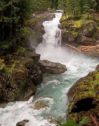
Narada Falls is a waterfall in Mount Rainier National Park, in the U.S. state of Washington. It is said to be the most popular, because the Mount Rainier Highway crosses the falls between its two tiers.
The Ohanapecosh River is a 16-mile (26 km) river in the U.S. state of Washington.
Bull Canyon is a canyon at the top of Palm Canyon Wash, which is a tributary to the Whitewater River, in Riverside County, California. Bull Canyon and the creek of Palm Canyon Wash heads at 33°36′47″N116°33′23″W, at an elevation of 6,165 feet in the southern western slope of a ridge in the San Jacinto Mountains. The waters of the creek of Palm Canyon Wash are augmented by Bull Canyon Spring at 33°35′22″N116°33′24″W, at an elevation of 5,331 feet / 1,625 meters. The mouth of Bull Canyon is at an elevation of 4,508 feet / 1,374 meters at the head of Palm Canyon. The mouth of an unnamed creek flows north down from Vandeventer Flat into the head of Palm Canyon at its confluence with Palm Canyon Wash at 33°34′08″N116°31′43″W at an elevation of 4,460 feet.
La Vereda del Monte was a backcountry route through remote regions of the Diablo Range, one of the California Coast Ranges. La Vereda del Monte was the upper part of La Vereda Caballo,, used by mesteñeros from the early 1840s to drive Alta California horses to Sonora for sale.
Dege Peak is a 7,006-foot summit located in Pierce County of Washington state. It is part of the Sourdough Mountains in Mount Rainier National Park. It was named in 1932 for James Henry Dege, a prominent Tacoma businessman and Captain of the First Regiment National Guard of Washington. His mother was a descendant of President Zachary Taylor.

Antler Peak is a 7,017 feet (2,139 m) summit located in Mount Rainier National Park in Pierce County of Washington state. It is part of the Sourdough Mountains, a subset of the Cascade Range. Antler Peak is situated west of Dege Peak and northeast of Sunrise Historic District, with the Sourdough Ridge Trail traversing the south slope of Antler between the two. Mount Fremont is its nearest higher peak, 1.55 mi (2.49 km) to the west. Precipitation runoff from Antler Peak drains into the White River.

Mount Fremont is a 7,214-foot-elevation mountain summit located in Mount Rainier National Park in Pierce County of Washington state. Mount Fremont is a minor peak at the southwest corner of the Sourdough Mountains which are a subset of the Cascade Range. It also the juncture for a small ridge of peaks of similar size running to the northeast. Mount Fremont is situated northwest of the Sunrise Historic District, with a popular trail leading to the Mount Fremont Fire Lookout. However, this trail does not reach the true summit which is 0.25 mi (0.40 km) north of Frozen Lake. Peak 7317, also known as Mount Fremont North, located 0.31 mi (0.50 km) west-northwest along the ridge is its nearest higher neighbor. Access is limited by snowpack closing the Sunrise Road much of the year. July, August, and September are typically the months when the Sunrise Road is seasonally open for vehicle traffic. Precipitation runoff from Mount Fremont drains into the White River.
McNeeley Peak is a 6,786-foot-elevation summit located in Mount Rainier National Park in Pierce County of Washington state. It is part of the Sourdough Mountains, a subset of the Cascade Range. McNeeley Peak is situated north of the Sunrise Historic District, east of Mount Fremont, and northwest of Antler Peak. The peak was named in 1932 for Edwin J. McNeeley, a prominent Tacoma businessman. Access is limited by snow closing the Sunrise Road much of the year. July, August, and September are typically the months when the Sunrise Road is seasonally open for vehicle traffic. Precipitation runoff from McNeeley Peak drains into the White River.

Marcus Peak is a 6,962 feet (2,122 m) summit located in Mount Rainier National Park in Pierce County of Washington state. It is part of the Sourdough Mountains, a subset of the Cascade Range and is situated north of Dege Peak. The peak was named in 1932 for Marcus Whitman (1802–1847), an early pioneer and physician. The Whitman Glacier on Little Tahoma also honors him. Access to Marcus Peak is limited due to snow closing the Sunrise Road much of the year. July, August, and September are typically the months when the Sunrise Road is seasonally open for vehicle traffic. The nearest higher peak is Palisades Peak, 0.64 miles (1.03 km) to the north-northeast. Precipitation runoff from Marcus Peak drains into the White River.

Tamanos Mountain is a 6,790-foot (2,070 m) summit located in Mount Rainier National Park in Pierce County of Washington state. It is part of the Cascade Range. Tamanos Mountain is situated west of Governors Ridge and northeast of the Cowlitz Chimneys, all of which can be seen from the Sunrise Historic District. The name tamanos derives from Chinook Jargon and has the meaning of guardian spirit. This landform's toponym was officially adopted by the U.S. Board on Geographic Names in 1932. Topographic relief is significant as the summit rises 3,100 feet above the White River in approximately 1.5 mile. The normal climbing access is from the Owyhigh Lakes Trail, and from the lakes scrambling up the south slope to the summit.

Barrier Peak is a small 6,521 ft summit located in Mount Rainier National Park in Pierce County of Washington state. It is part of the Cascade Range and is situated west of Cayuse Pass, 0.53 mile west-northwest of Buell Peak, and 0.4 mile south-southwest of Governors Ridge, which is its nearest higher peak. The normal climbing access is from the Owyhigh Lakes Trail. The peak was so named because it served as a barrier between the Cayuse Pass region and the rest of Mount Rainier National Park.

Goat Island Mountain is a 7,288 feet (2,221 m) ridge-like mountain located in Mount Rainier National Park, in Pierce County of Washington state. It is part of the Cascade Range, and lies 5.76 mi (9.27 km) east-northeast of the summit of Mount Rainier. This mountain is quite visible from the Sunrise Historic District and the many trails surrounding the Sunrise area. The Wonderland Trail provides an approach to this mountain, and the summit offers views of Cowlitz Chimneys, Fryingpan Glacier, and Mount Rainier. Burroughs Mountain is its nearest higher neighbor, 2.51 mi (4.04 km) to the northwest. Precipitation runoff from Goat Island Mountain drains into the White River. The mountain's descriptive name derives from mountain goats that were often seen on the peak. The name was officially adopted in 1932 by the United States Board on Geographic Names.

