
The Homestead Acts were several laws in the United States by which an applicant could acquire ownership of government land or the public domain, typically called a homestead. In all, more than 160 million acres of public land, or nearly 10 percent of the total area of the United States, was given away free to 1.6 million homesteaders; most of the homesteads were west of the Mississippi River.

The City of Sheridan is a home rule municipality located in Arapahoe County, Colorado, United States. Sheridan is a part of the Denver–Aurora–Lakewood, CO Metropolitan Statistical Area. The population was 6,105 at the 2020 census.

Bear Lake is a village in Manistee County in the U.S. state of Michigan. The population was 342 at the 2020 census. The village is located within Bear Lake Township.

The Dominion Lands Act was an 1872 Canadian law that aimed to encourage the settlement of the Canadian Prairies and to help prevent the area being claimed by the United States. The Act was closely based on the U.S. Homestead Act of 1862, setting conditions in which the western lands could be settled and their natural resources developed.
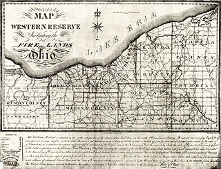
A survey township, sometimes called a Congressional township or just township, as used by the United States Public Land Survey System and by Canada's Dominion Land Survey is a nominally-square area of land that is nominally six survey miles on a side. Each 36-square-mile township is divided into 36 sections of one square mile each. The sections can be further subdivided for sale.
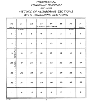
In U.S. land surveying under the Public Land Survey System (PLSS), a section is an area nominally one square mile, containing 640 acres, with 36 sections making up one survey township on a rectangular grid.
At 47,527 acres (192.33 km2), Harriman State Park is the second largest state park in the U.S. state of New York. Located in Rockland and Orange counties 30 miles (48 km) north of New York City, it is a haven for hikers with over 200 miles (320 km) of hiking trails. The park is also known for its 31 lakes, multiple streams, public camping area, and great vistas. The park's hiking trails are currently maintained by volunteers from the New York - New Jersey Trail Conference.
The Southern Homestead Act of 1866 is a United States federal law enacted to break a cycle of debt during the Reconstruction following the American Civil War. Prior to this act, blacks and whites alike were having trouble buying land. Sharecropping and tenant farming had become ways of life. This act attempted to solve this by selling land at low prices so Southerners could buy it. Many people, however, could still not participate because the low prices were still too high.
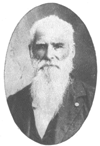
Daniel Freeman was an American homesteader and Civil War veteran. He was recognized as the first person to file a claim under the Homestead Act of 1862.

Jacob Summerlin, aka the King of the Crackers and King of the Cracker Cow Hunters, was documented as the first child born in Florida after the land was ceded by Spain. This was again validated in about 2012-15 during Florida's 500-year celebration as Florida honored him as one of three people that were most influential in the past 500 years. Ponce de Leon was another of 3 honored.
Homestead National Historical Park, a unit of the National Park System known as the Homestead National Monument of America prior to 2021, commemorates passage of the Homestead Act of 1862, which allowed any qualified person to claim up to 160 acres (0.65 km2) of federally owned land in exchange for five years of residence and the cultivation and improvement of the property. The Act eventually transferred 270,000,000 acres (1,100,000 km2) from public to private ownership.
The University of Texas at Austin was originally conceived in 1827 under an article in the Constitución de Coahuila y Texas to open a public university in the state of Texas. The Constitution of 1876 also called for the creation of a "university of the first class." Thus, they created "The University of Texas." Since the school's opening in 1883, the University of Texas has expanded greatly with the Austin institution remaining the flagship university of the University of Texas System. By the late 1990s, the University had the largest enrollment in the country and contained many of the country's top programs in the areas of law, architecture, film, engineering, and business.

Strongfield is a village in the Canadian province of Saskatchewan within the Rural Municipality of Loreburn No. 254 and Census Division No. 11. It lies approximately 100 km south of the City of Saskatoon on Highway 19 between its sister communities of Hawarden and Loreburn.
Branscomb is an unincorporated community in Mendocino County in the U.S. state California. It is located 8 miles (13 km) west-southwest of Laytonville, at an elevation of 1565 feet, on a river terrace to the east of the South Fork Eel River.

The Homestead Act of 1860 in the United States would have made land available for 25 cents per acre. This act was passed by the United States Congress, but was ultimately vetoed by President James Buchanan.
Rancho Suscol was an 84,000-acre (340 km2) Mexican land grant in present day Sonoma County, California, Napa County, California, and Solano County, California, given in 1843 by Governor Manuel Micheltorena to General Mariano Guadalupe Vallejo. In a significant land law decision, the land claim was rejected by the US Supreme Court in 1862. Rancho Suscol extended from Rancho Petaluma on the west, south down to the San Francisco Bay and Mare Island and Carquinez Strait, and then to Rancho Suisun on the east. It included present day cities of Vallejo and Benicia.
The Florida Armed Occupation Act of 1842 was passed as an incentive to grow the population of Florida.

Rancho La Puente was a ranch in the southern San Gabriel Valley that measured just under 49,000 acres (200 km2), and remained intact from its establishment in the late 1700s as an outpost of Mission San Gabriel until about 1870. By modern landmarks, the ranch extended from San Gabriel River on the west to just west of the 57 Freeway on the east and from Ramona Boulevard/San Bernardino Road on the north to the Puente Hills on the south. All but 40 acres (160,000 m2), which fall within Orange County, are within Los Angeles County. The present communities of Avocado Heights, Bassett, Baldwin Park, San Dimas, Rowland Heights, Hacienda Heights, City of Industry, La Puente, Walnut, Covina, West Covina, and small sections of South El Monte and Irwindale are contained within the old boundaries of Rancho La Puente.
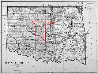
"Boomers" is the name used for two groups of settlers in the Southern United States in what is now the state of Oklahoma.
Colorado State University Mountain Campus, formerly Pingree Park, is a satellite campus of the Fort Collins, Colorado-based Colorado State University. CSU Mountain Campus is situated in Pingree Valley in the Mummy Range at 9,053 ft (2,759 m) approximately 24 miles (39 km) from the city of Fort Collins, Colorado.