Related Research Articles

The Sea of Okhotsk is a marginal sea of the western Pacific Ocean. It is located between Russia's Kamchatka Peninsula on the east, the Kuril Islands on the southeast, Japan's island of Hokkaido on the south, the island of Sakhalin along the west, and a stretch of eastern Siberian coast along the west and north. The northeast corner is the Shelikhov Gulf. The sea is named for the port of Okhotsk, itself named for the Okhota River.

The Bering Sea is a marginal sea of the Northern Pacific Ocean. It forms, along with the Bering Strait, the divide between the two largest landmasses on Earth: Eurasia and the Americas. It comprises a deep water basin, which then rises through a narrow slope into the shallower water above the continental shelves. The Bering Sea is named after Vitus Bering, a Danish navigator in Russian service, who, in 1728, was the first European to systematically explore it, sailing from the Pacific Ocean northward to the Arctic Ocean.

Laurasia was the more northern of two large landmasses that formed part of the Pangaea supercontinent from around 335 to 175 million years ago (Mya), the other being Gondwana. It separated from Gondwana 215 to 175 Mya during the breakup of Pangaea, drifting farther north after the split and finally broke apart with the opening of the North Atlantic Ocean c. 56 Mya. The name is a portmanteau of Laurentia and Asia.

A continental shelf is a portion of a continent that is submerged under an area of relatively shallow water, known as a shelf sea. Much of these shelves were exposed by drops in sea level during glacial periods. The shelf surrounding an island is known as an insular shelf.

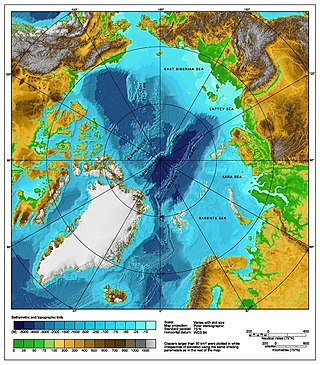
The East Siberian Sea is a marginal sea in the Arctic Ocean. It is located between the Arctic Cape to the north, the coast of Siberia to the south, the New Siberian Islands to the west and Cape Billings, close to Chukotka, and Wrangel Island to the east. This sea borders on the Laptev Sea to the west and the Chukchi Sea to the east.

The Chukchi Sea, sometimes referred to as the Chuuk Sea, Chukotsk Sea or the Sea of Chukotsk, is a marginal sea of the Arctic Ocean. It is bounded on the west by the Long Strait, off Wrangel Island, and in the east by Point Barrow, Alaska, beyond which lies the Beaufort Sea. The Bering Strait forms its southernmost limit and connects it to the Bering Sea and the Pacific Ocean. The principal port on the Chukchi Sea is Uelen in Russia. The International Date Line crosses the Chukchi Sea from northwest to southeast. It is displaced eastwards to avoid Wrangel Island as well as the Chukotka Autonomous Okrug on the Russian mainland.

Arctica, or Arctida was an ancient continent which formed approximately 2.565 billion years ago in the Neoarchean era. It was made of Archaean cratons, including the Siberian Craton, with its Anabar/Aldan shields in Siberia, and the Slave, Wyoming, Superior, and North Atlantic cratons in North America. Arctica was named by Rogers 1996 because the Arctic Ocean formed by the separation of the North American and Siberian cratons. Russian geologists writing in English call the continent "Arctida" since it was given that name in 1987, alternatively the Hyperborean craton, in reference to the hyperboreans in Greek mythology.

Baltica is a paleocontinent that formed in the Paleoproterozoic and now constitutes northwestern Eurasia, or Europe north of the Trans-European Suture Zone and west of the Ural Mountains. The thick core of Baltica, the East European Craton, is more than three billion years old and formed part of the Rodinia supercontinent at c. 1 Ga.

New Siberia is the easternmost of the Anzhu Islands, the northern subgroup of the New Siberian Islands lying between the Laptev Sea and East Siberian Sea. Its area of approximately 6,200 square kilometres places it the 102nd largest islands in the world. New Siberia Island is low lying, rising to only 76 metres and covered with tundra vegetation. The island is a part of the territory of Yakutia, Russia.
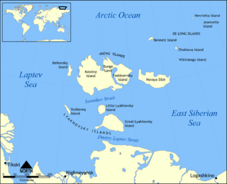
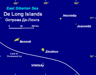
The De Long Islands are an uninhabited archipelago often included as part of the New Siberian Islands, lying north east of Novaya Sibir.

The Caledonian orogeny was a mountain-building cycle recorded in the northern parts of the British Isles, the Scandinavian Caledonides, Svalbard, eastern Greenland and parts of north-central Europe. The Caledonian orogeny encompasses events that occurred from the Ordovician to Early Devonian, roughly 490–390 million years ago (Ma). It was caused by the closure of the Iapetus Ocean when the Laurentia and Baltica continents and the Avalonia microcontinent collided.

Cimmeria was an ancient continent, or, rather, a string of microcontinents or terranes, that rifted from Gondwana in the Southern Hemisphere and was accreted to Eurasia in the Northern Hemisphere. It consisted of parts of present-day Turkey, Iran, Afghanistan, Pakistan, Tibet, China, Myanmar, Thailand, and Malaysia. Cimmeria rifted from the Gondwanan shores of the Paleo-Tethys Ocean during the Early Permian and as the Neo-Tethys Ocean opened behind it, during the Permian, the Paleo-Tethys closed in front of it. Because the different chunks of Cimmeria drifted northward at different rates, a Meso-Tethys Ocean formed between the different fragments during the Cisuralian. Cimmeria rifted off Gondwana from east to west, from Australia to the eastern Mediterranean. It stretched across several latitudes and spanned a wide range of climatic zones.
The Arctic consists of land, internal waters, territorial seas, exclusive economic zones (EEZs) and international waters above the Arctic Circle. All land, internal waters, territorial seas and EEZs in the Arctic are under the jurisdiction of one of the eight Arctic coastal states: Canada, Denmark, Finland, Iceland, Norway, Russia, Sweden and the United States. International law regulates this area as with other portions of Earth.

The continental shelf of Russia is a continental shelf adjacent to the Russian Federation. Geologically, the extent of the shelf is defined as the entirety of the continental shelves adjacent to Russia's coast. In international law, however, the United Nations Convention on the Law of the Sea more narrowly defines the extent of the shelf as the seabed and subsoil of the submarine areas over which a state exercises sovereign rights.
The Laptev Sea Rift is a divergent tectonic plate boundary between the North American Plate and the Eurasian Plate located on the Arctic Ocean coast of northeastern Siberia in Russia. The Laptev Sea Rift is the continuation of the Gakkel Ridge into the continental crust of Siberia. It starts offshore in the continental shelf and continues onshore to a point located in the Chersky Range where the boundary motion changes from extension to compression.

The Arctic Ocean is the smallest and shallowest of the world's five major oceans. It spans an area of approximately 14,060,000 km2 (5,430,000 sq mi) and is known as one of the coldest of oceans. The International Hydrographic Organization (IHO) recognizes it as an ocean, although some oceanographers call it the Arctic Mediterranean Sea. It has also been described as an estuary of the Atlantic Ocean. It is also seen as the northernmost part of the all-encompassing World Ocean.
This is a list of articles related to plate tectonics and tectonic plates.
The Chukchi Plateau or Chukchi Cap is a large subsea formation extending north from the Alaskan margin into the Arctic Ocean. The ridge is normally covered by ice year-round, and reaches an approximate bathymetric prominence of 3,400 m with its highest point at 246 m below sea level. As a subsea ridge extending from the continental shelf of the United States north of Alaska, the Chukchi Plateau is an important feature in maritime law of the Arctic Ocean and has been the subject of significant geographic research. The ridge has been extensively mapped by the USCGC Healy, and by the Canadian icebreaker CCGS Louis S. St-Laurent in 2011 and RV Marcus Langseth, a National Science Foundation vessel operated by the Lamont–Doherty Earth Observatory of Columbia University.
References
- ↑ Thurston, Dennis K.; Fujita, Kazuya (1992). 1992 Proceedings, International Conference on Arctic Margins. p. 190.
- ↑ Piskarev, A. & Shkatov, M. (2012). Energy Potential of the Russian Arctic Seas. Elsevier: Developments in Petroleum Science. p. 136-138.
{{cite book}}: CS1 maint: multiple names: authors list (link)