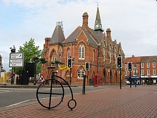
Wokingham is a market town and civil parish in Berkshire, England, 37 miles (60 km) west of London, 7 miles (11 km) southeast of Reading, 8 miles (13 km) north of Camberley and 4 miles (6 km) west of Bracknell. It is the main administrative centre of the wider Borough of Wokingham. In 2011 it had a population of 50,320.

Maidenhead is a market town in the Royal Borough of Windsor and Maidenhead in the county of Berkshire, England, on the southwestern bank of the River Thames. In the 2021 Census, it had an estimated population of 70,374 and forms part of the border with southern Buckinghamshire. The town is situated 27 miles (43 km) west of Charing Cross, London and 13 miles (21 km) east-northeast of the county town of Reading. The town differs from the Parliamentary constituency of Maidenhead, which includes a number of outer suburbs and villages, including villages which form part of the Borough of Wokingham such as Twyford, Charvil, Remenham, Ruscombe and Wargrave.

Bracknell is a town and civil parish in Berkshire, England, the westernmost area within the Greater London Urban Area and the administrative centre of the borough of Bracknell Forest. It lies 11 miles (18 km) to the east of Reading, 9 miles (14 km) south of Maidenhead, 10 miles (16 km) southwest of Windsor and 25 miles (40 km) west of central London. Bracknell is the third largest town in Berkshire.

The Royal Borough of Windsor and Maidenhead is a royal borough and unitary authority in Berkshire, South East England. While it is named after both the towns of Maidenhead and Windsor, the borough also covers the nearby towns of Ascot and Eton. It is home to Windsor Castle, Eton College, Legoland Windsor and Ascot Racecourse. It is one of four boroughs entitled to be prefixed Royal and is one of six unitary authorities in the county, which has historic and ceremonial status.
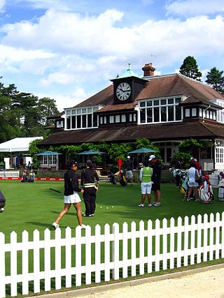
Sunningdale is a large village with a retail area and a civil parish in the Royal Borough of Windsor and Maidenhead. It takes up the extreme south-east corner of Berkshire, England. It has a railway station on the (London) Waterloo to Reading Line and is adjoined by green buffers including Sunningdale Golf Club and Wentworth Golf Club. Its northern peripheral estates adjoin Virginia Water Lake.
Earley is a town and civil parish in the Borough of Wokingham, Berkshire, England. Along with the neighbouring town of Woodley, the Office for National Statistics places Earley within the Reading/Wokingham Urban Area; for the purposes of local government it falls within the Borough of Wokingham, outside the area of Reading Borough Council. Its name is sometimes spelt Erleigh or Erlegh and consists of a number of smaller areas, including Maiden Erlegh and Lower Earley, and lies some 3 miles (5 km) south and east of the centre of Reading, and some 4 miles (6 km) northwest of Wokingham. It had a population of 32,036 at the 2011 Census.
Tilehurst is a suburb of the town of Reading in the county of Berkshire, England. It lies to the west of the centre of Reading; it extends from the River Thames in the north to the A4 road in the south.

Sonning is a village and civil parish in Berkshire, England, on the River Thames, east of Reading. The village was described by Jerome K. Jerome in his book Three Men in a Boat as "the most fairy-like little nook on the whole river".

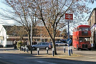
Hurst is a village in the civil parish of St Nicholas Hurst in the Borough of Wokingham, Berkshire, England. The village lies between Twyford and Wokingham, about 1.5 miles (2.4 km) north of the M4 motorway.

Ascot is a town in the Royal Borough of Windsor and Maidenhead in Berkshire, England. It is 6 miles (9.7 km) south of Windsor, 4 miles (6.4 km) east of Bracknell and 25 miles (40 km) west of London.

Theale is a village and civil parish in West Berkshire, England. It is 5 miles (8 km) southwest of Reading and 10 miles (16 km) east of Thatcham. The compact parish is bounded to the south and south-east by the Kennet & Avon Canal, to the north by a golf course, to the east by the M4 motorway and to the west by the A340 road.

Coley is an inner-town district near the centre of the town of Reading, in the English county of Berkshire. It is often referred to as Old Coley, to distinguish it from the adjacent, and much more recent, suburb of Coley Park.
North Ascot is an area of Bracknell Forest in the county of Berkshire in England, with a few acres straddling the town of Ascot in the Royal Borough of Windsor and Maidenhead. It lies north of the A329 and west of the A332, adjoining the Ascot Racecourse, Heatherwood Hospital and the village of Burleigh.

Sunninghill is a village in the civil parish of Sunninghill and Ascot in the Royal Borough of Windsor and Maidenhead in the English county of Berkshire.
Cheapside describes a close triangle of roads in the civil parish of Sunninghill and Ascot and ecclesiastical parish of Sunninghill in the Royal Borough of Windsor and Maidenhead in Berkshire, England which includes a school and had a Methodist chapel. It is a cluster of houses, bungalows and cottages. It is marked on maps as the area north and east of Silwood Park and south of Sunninghill Park. Harewood Lodge followed by Titness House to its immediate east are of similar 18th century construction and have sometimes been recorded as in the Cheapside locality.
Sunninghill and Ascot is a civil parish in the Royal Borough of Windsor and Maidenhead and takes up most of the south-east corner of the English county of Berkshire. It covers the town of Ascot, and the village of Sunninghill including the neighbourhoods Cheapside and South Ascot. As well as part of the village of North Ascot.

Woodside is a hamlet in Berkshire, England, within the civil parishes of Winkfield and Sunninghill and Ascot in the boroughs of Bracknell Forest and Windsor and Maidenhead. The settlement lies near to the A332 road and is approximately 1.5 miles (2.4 km) north-east of Ascot Racecourse and largely surrounded by Windsor Great Park. In the early Twentieth Century the south of the hamlet was the site of the Ascot Brick Works. It has two pubs The Rose and Crown and the Duke of Edinburgh but no shops or church, as such it is probably best described as a hamlet and not a village. It features several historic houses and buildings. In the 19th and early 20th Century there were two distinct hamlets:
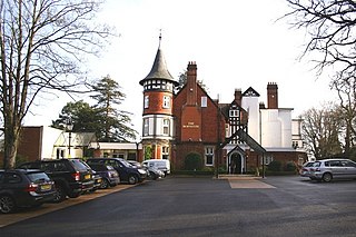
The Berystede is a hotel in the village of South Ascot, Berkshire, England.

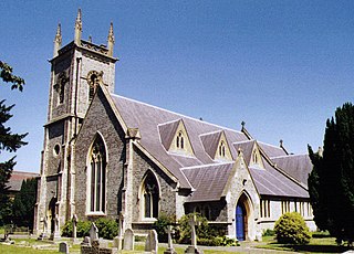
The Church of Saint Michael and All Angels is in the village of Sunninghill, in Berkshire, England. It is an active Anglican parish church in the diocese of Oxford. It is in the parish of Sunninghill and South Ascot with the church of All Souls in South Ascot. It is dedicated to Saint Michael and all angels.

