Interstate 385 (I-385) is an Interstate Highway located in the Upstate region of South Carolina. I-385 is a spur route of Interstate 85. The highway provides a connection between Greenville and Columbia.
Interstate 585 (I-585) is a spur route of I-85, which connects Spartanburg, South Carolina in the United States.

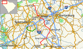
U.S. Route 221 (US 221) is a 734-mile-long (1,181 km) spur of U.S. Route 21. It travels from Perry, Florida, at US 19/US 98/US 27 Alternate to Lynchburg, Virginia, at US 29 Business. It travels through the states of Florida, Georgia, South Carolina, North Carolina, and Virginia. It travels through the cities of Valdosta, Georgia; Spartanburg, South Carolina; Marion, North Carolina; Roanoke, Virginia; and Lynchburg, Virginia.
In the U.S. state of South Carolina, Interstate 85 (I-85) runs northeast-southwest through Upstate South Carolina. Connecting regionally with Atlanta, Georgia and Charlotte, North Carolina, it became the first Interstate highway in South Carolina to have its originally planned mileage completed.

South Carolina Highway 8 is a primary state highway in the U.S. state of South Carolina. It runs from U.S. Route 276 (US 276) in northern Greenville County to US 25 and SC 418 in Ware Place. It runs physically north and south though it is signed as a west-east highway with its western terminus at US 276 and its eastern terminus at US 25/SC 418.

South Carolina Highway 14 is a state highway in the U.S. state of South Carolina. The state highway runs 59.24 miles (95.34 km) from U.S. Route 76 Business in Laurens north to Interstate 26 (I-26) in Landrum. SC 14 connects Laurens and Landrum with Greer, the city between Greenville and Spartanburg where the highway crosses I-85 and US 29. The highway also parallels I-385 through Fountain Inn and Simpsonville, South Carolina in southeastern Greenville County. SC 14 is a part of the National Highway System between I-85 and US 29 in Greer.
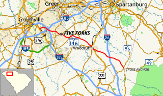
South Carolina Highway 146 is a 33 1⁄2-mile-long (53.9 km) South Carolina state highway running through Central Greenville County and south-western Spartanburg County.
South Carolina Highway 417 (SC 417) is a numbered state highway in central Greenville and Spartanburg counties in northern South Carolina.
South Carolina Highway 101 is a state route in Laurens, Spartanburg, and Greenville counties. Its southern terminus is at a junction with U.S. Route 76 in Hickory Tavern, and its northern terminus is at a junction with SC 11 near Landrum.
South Carolina Highway 290 is a state highway in South Carolina, United States, that courses through central Greenville and Spartanburg Counties.
South Carolina Highway 296 (SC 296) is an east-west state highway coursing through central Greenville and Spartanburg counties in north-central South Carolina.

U.S. Route 221 (US 221) is a part of the United States Numbered Highway System that runs from Perry in northern Florida to Lynchburg in central Virginia. In South Carolina, the highway runs north to south from the Georgia state line near Clarks Hill to the North Carolina state line near Chesnee. While in the state, the highway passes through Greenwood, Laurens, Woodruff, and Spartanburg. The highway mostly travels through rural parts of the Piedmont region of the state.

South Carolina Highway 56 (SC 56) is a primary state highway in the state of South Carolina. The highway provides a back country alternative to Interstate 26 (I-26) from Clinton to Spartanburg.
South Carolina Highway 358 (SC 358) is a short state highway in South Carolina that runs near Lyman through more rural and suburban parts of Spartanburg County.
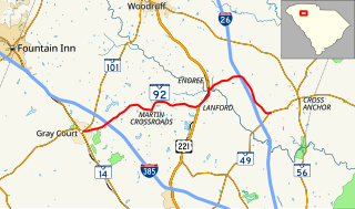
South Carolina Highway 92 (SC 92) is a 16.2-mile-long (26.1 km) state highway in the U.S. state of South Carolina. The highway connects Gray Court with the Enoree area.
South Carolina Highway 292 (SC 292) is a 13.4-mile-long (21.6 km) state highway in the U.S. state of South Carolina. The highway connects Duncan and the Inman area, via Lyman.


