South Carolina Highway 223

Last updated

South Carolina 223.svg

South Carolina Highway 223
Wylies Mill Road
SC 223 map.svg
Route information
Maintained by SCDOT
Length 6.74 mi [1] (10.85 km)
Existed 1940 – present
Major junctions
West endSouth Carolina 9.svgSouth Carolina 901.svg SC 9 / SC 901 near Richburg
East endUS 21.svg US 21 in Landsford
Location
Counties Chester
Highway system
US 221.svg US 221 SC 225 South Carolina 225.svg

South Carolina Highway 223 (SC 223) is a primary state highway in the U.S. state of South Carolina. It serves as a connector between Richburg and Landsford Canal State Park.

A state highway, state road, or state route is usually a road that is either numbered or maintained by a sub-national state or province. A road numbered by a state or province falls below numbered national highways in the hierarchy. Roads maintained by a state or province include both nationally numbered highways and un-numbered state highways. Depending on the state, "state highway" may be used for one meaning and "state road" or "state route" for the other.

South Carolina State of the United States of America

South Carolina is a state in the Southeastern United States and the easternmost of the Deep South. It is bordered to the north by North Carolina, to the southeast by the Atlantic Ocean, and to the southwest by Georgia across the Savannah River.

Richburg, South Carolina Town in South Carolina, United States

Richburg is a town in Chester County, South Carolina, United States. The population was 275 at the 2010 census, down from 332 at the 2000 census.

Contents

Route description

SC 223 near Richburg South Carolina Highway 223 Sign.JPG
SC 223 near Richburg

SC 223 is a two-lane rural highway that traverses 6.7 miles (10.8 km) from SC 9 and SC 901 outside of Richburg to U.S. Route 21 (US 21) in the community of Landsford and Landsford Canal State Park. [2] [3]

South Carolina Highway 9 highway in South Carolina

South Carolina Highway 9 is a 258.3-mile-long (416 km) major state highway in the U.S. state of South Carolina. The route runs from North Myrtle Beach to the North Carolina border upstate. The road is currently the longest state highway in South Carolina. It is signed as a north–south highway though overall it runs in an east–west direction.

South Carolina Highway 901 (SC 901) is a primary state highway in the U.S. state of South Carolina. It serves as a slower alternate rural route to Interstate 77 (I-77) and the western bypass of Rock Hill.

History

The first SC 223 appeared from 1939-1940 as a spur off SC 22, renumbered as an extension of SC 901.

South Carolina Highway 22 highway in South Carolina

South Carolina Highway 22 (SC 22), also known as the Conway Bypass and Veterans Highway, is a four lane freeway that connects US 501 north of Conway, South Carolina to US 17 in Myrtle Beach. The road was opened to traffic on May 4, 2001, six months ahead of schedule. There is speculation that it could become part of Interstate 73 in the future. The road largely meets Interstate Highway standards, but in order to support increased Interstate traffic, its shoulders would need to be expanded to standard width.

The current SC 223 was established in 1940, connecting Richburg with US 21. In 1948, it was briefly downgraded as a secondary road, but was resurrected a year later after the road was fully paved; changed little since. [4]

Junction list

The entire route is in Chester County.

Locationmi [1] kmDestinationsNotes
0.000.00South Carolina 9.svgSouth Carolina 901.svg SC 9 / SC 901 (Lancaster Highway) Lancaster, Chester
Landsford 6.7410.85US 21.svg US 21 (Catawba River Road) Fort Lawn, Rock Hill
1.000 mi = 1.609 km; 1.000 km = 0.621 mi

Related Research Articles

South Carolina Highway 5 highway in South Carolina

South Carolina Highway 5 (SC 5) is a primary state highway in the U.S. state of South Carolina. The highway connects the cities of Rock Hill, York and Blacksburg.

South Carolina Highway 34 highway in South Carolina

South Carolina Highway 34 (SC 34) is a primary state highway in the U.S. state of South Carolina. As one of the longer state highways, it traverses the state east-west from Greenwood to Dillon, connecting the cities of Newberry, Winnsboro, Camden, Bishopville and Darlington.

Interstate 77 (I-77) is a south–north interstate highway, extending 91.2 miles (146.8 km) in the state of South Carolina, extending from the national southern terminus at an interchange with I-26 near Columbia, north to the North Carolina state line near Rock Hill and Charlotte, NC.

South Carolina Highway 421 highway in South Carolina

South Carolina Highway 421 (SC 421) is a primary state highway in the U.S. state of South Carolina. It is an alternate route to U.S. Route 1 (US 1) and US 78 between North Augusta and Aiken.

South Carolina Highway 121 highway in South Carolina

South Carolina Highway 121 (SC 121) is a major state highway that runs north and south in the western part of the U.S. state of South Carolina. The road is actually part of a long multi-state route that also goes through Florida and Georgia. Some see it as a de facto auxiliary route from U.S. Route 21 (US 21) in Rock Hill. Efforts to have the road upgraded to such status have failed however.

South Carolina Highway 72 highway in South Carolina

South Carolina Highway 72 (SC 72) is a 125-mile (201 km) state highway, traversing interior portions of the South Carolina Piedmont region. The route connects many smaller communities outside major metropolitan areas and is roughly parallel with Interstate 85 (I-85) to the north and interstates 20 and 77 to the south and east. The route shares the longest concurrency in the state with SC 121, from Whitmire to Rock Hill.

South Carolina Highway 262 highway in South Carolina

South Carolina Highway 262 (SC 262) is a primary state highway in the U.S. state of South Carolina. It serves primarily as the southern border of Fort Jackson.

South Carolina Highway 909 highway in South Carolina

South Carolina Highway 909 (SC 909) is a primary state highway in the U.S. state of South Carolina. It connects the communities of northern Chester County.

South Carolina Highway 403 (SC 403) is a primary state highway in the U.S. state of South Carolina. It serves the town of Timmonsville and the surrounding rural area with the cities of Lake City and Hartsville.

South Carolina Highway 212

South Carolina Highway 212 (SC 212) is a primary state highway in the U.S. state of South Carolina. It serves the town of Williams by connecting it with nearby highways.

South Carolina Highway 47

South Carolina Highway 47 (SC 47) is a primary state highway in the U.S. state of South Carolina. It serves to connect the town of Elloree with U.S. Route 301 (US 301).

South Carolina Highway 327 (SC 327) is a primary state highway in the U.S. state of South Carolina. It serves as an alternative bypass east of Florence and a connector route from Interstate 95 (I-95) to Myrtle Beach.

South Carolina Highway 20

South Carolina Highway 20 (SC 20) is a primary state highway in the U.S. state of South Carolina. The highway connects the cities of Abbeville, Belton, Williamston and Greenville. The 53-mile-long (85 km) highway is signed as a west-east highway though it physically runs south-to-north.

South Carolina Highway 66

South Carolina Highway 66 (SC 66) is a primary state highway in the state of South Carolina. It serves to connect the community of Joanna with nearby SC 56 and the town of Whitmire.

South Carolina Highway 19

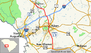
South Carolina Highway 19 (SC 19) is a primary state highway in the U.S. state of South Carolina. It connects Aiken directly with the Savannah River Site and Edgefield via U.S. Route 25 (US 25).

South Carolina Highway 99

South Carolina Highway 99 (SC 99) is a 9-mile-long (14 km) state highway in the U.S. state of South Carolina. The highway connects Great Falls with rural areas of Chester County.

South Carolina Highway 914 (SC 914) is a 1.7-mile-long (2.7 km) state highway in the U.S. state of South Carolina. The highway connects Lancaster and Springdale, via Lancaster Mill.

References

  1. 1 2 "Statewide Highways (shapefile)" (zip). South Carolina Department of Transportation. September 29, 2017. Retrieved December 8, 2017.
  2. General Highway System - Chester County, South Carolina (PDF) (Map). South Carolina Department of Transportation. June 2005. Retrieved February 2, 2013.
  3. Google (November 23, 2012). "South Carolina Highway 223" (Map). Google Maps . Google. Retrieved November 23, 2012.
  4. "Mapmikey's South Carolina Highways Page (SC 220-229)" . Retrieved November 23, 2012.[ unreliable source ]

Route map: Google

KML file (edithelp)
KML is from Wikidata