Richburg, South Carolina

Last updated

Richburg, South Carolina
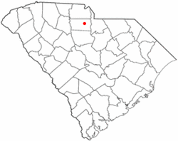
SCMap-doton-Richburg.PNG
Location of Richburg, South Carolina
Coordinates: 34°43′3″N81°1′11″W / 34.71750°N 81.01972°W / 34.71750; -81.01972
Country United States
State South Carolina
County Chester
Government
  MayorJames Harris [1]
Area
[2]
  Total0.88 sq mi (2.27 km2)
  Land0.88 sq mi (2.27 km2)
  Water0.00 sq mi (0.00 km2)
Elevation
[3]
584 ft (178 m)
Population
 (2020) [4]
  Total280
  Density319.63/sq mi (123.37/km2)
Time zone UTC-5 (Eastern (EST))
  Summer (DST) UTC-4 (ES)
ZIP code
29729
Area code(s) 803, 839
FIPS code 45-59920 [5]
GNIS feature ID1250370 [3]

Richburg is a town in Chester County, South Carolina, United States. The population was 275 at the 2010 census, [6] down from 332 at the 2000 census.

Contents

History

The Elliott House and Landsford Plantation House are listed on the National Register of Historic Places. [7]

Geography

Richburg is located in east-central Chester County at 34°43′3″N81°1′11″W / 34.71750°N 81.01972°W / 34.71750; -81.01972 (34.717374, -81.019635). [8] Interstate 77 passes just west of the town, with access from Exits 62 and 65. I-77 leads north 40 miles (64 km) to Charlotte and south 53 miles (85 km) to Columbia. South Carolina Highway 9 passes through the northeast side of the town, leading west 13 miles (21 km) to Chester, the county seat, and east 16 miles (26 km) to Lancaster.

According to the United States Census Bureau, Richburg has a total area of 0.89 square miles (2.3 km2), all of it land. [6]

Demographics

Historical population
CensusPop.Note
1880 121
1890 18653.7%
1900 24029.0%
1910 2452.1%
1920 222−9.4%
1930 24510.4%
1940 183−25.3%
1950 23830.1%
1960 235−1.3%
1970 30429.4%
1980 269−11.5%
1990 40550.6%
2000 332−18.0%
2010 275−17.2%
2020 2801.8%
U.S. Decennial Census [9] [4]

As of the census [5] of 2000, there were 332 people, 122 households, and 87 families residing in the town. The population density was 400.2 inhabitants per square mile (154.5/km2). There were 134 housing units at an average density of 161.5 per square mile (62.4/km2). The racial makeup of the town was 23.49% White, 74.70% African American, 1.20% Asian, and 0.60% from two or more races. Hispanic or Latino of any race were 1.20% of the population.

There were 122 households, out of which 31.1% had children under the age of 18 living with them, 38.5% were married couples living together, 27.0% had a female householder with no husband present, and 27.9% were non-families. 24.6% of all households were made up of individuals, and 15.6% had someone living alone who was 65 years of age or older. The average household size was 2.72 and the average family size was 3.26.

In the town, the population was spread out, with 24.7% under the age of 18, 7.8% from 18 to 24, 21.7% from 25 to 44, 29.5% from 45 to 64, and 16.3% who were 65 years of age or older. The median age was 40 years. For every 100 females, there were 77.5 males. For every 100 females age 18 and over, there were 71.2 males.

The median income for a household in the town was $31,875, and the median income for a family was $40,000. Males had a median income of $35,893 versus $18,295 for females. The per capita income for the town was $13,048. About 9.7% of families and 13.6% of the population were below the poverty line, including 22.5% of those under age 18 and 21.4% of those age 65 or over.
Education

Richburg has a public library, a branch of the Chester County Library System. [10]

Media

Notable residents

Related Research Articles

<span class="mw-page-title-main">Chester County, South Carolina</span> County in South Carolina, United States

Chester County is a county located in the U.S. state of South Carolina. As of the 2020 census, its population was 32,294. Its county seat is Chester.

<span class="mw-page-title-main">Perry, South Carolina</span> Town in South Carolina, United States of America

Perry is a town in Aiken County, South Carolina, United States. The population was 233 at the 2010 census. It is part of the Augusta, Georgia metropolitan area.

<span class="mw-page-title-main">Olar, South Carolina</span> Town in South Carolina, United States

Olar is a town in Bamberg County, South Carolina, United States. The population was 257 at the 2010 census.

<span class="mw-page-title-main">Elko, South Carolina</span> Town in South Carolina, United States

Elko is a town in Barnwell County, South Carolina, United States. According to the 2010 census the population was 193.

<span class="mw-page-title-main">Kline, South Carolina</span> Town in South Carolina, United States

Kline is a town in Barnwell County, South Carolina, United States. The population was 197 at the 2010 census.

<span class="mw-page-title-main">Snelling, South Carolina</span> Town in South Carolina, United States

Snelling is a town in Barnwell County, South Carolina, United States. The population was 274 at the 2010 census.

<span class="mw-page-title-main">Williston, South Carolina</span> Town in South Carolina, United States

Williston is a town in Barnwell County, South Carolina, United States. The population was 3,139 at the 2010 census.

<span class="mw-page-title-main">Chester, South Carolina</span> City in South Carolina, United States

Chester is a small rural city in Chester County, South Carolina, United States. The population was 5,607 at the 2010 census, down from 6,476 at the 2000 census. It is the county seat of Chester County.

<span class="mw-page-title-main">Eureka Mill, South Carolina</span> Census-designated place in South Carolina, United States

Eureka Mill is a census-designated place (CDP) in Chester County, South Carolina, United States. The population was 1,476 at the 2010 census, down from 1,737 at the 2000 census.

<span class="mw-page-title-main">Fort Lawn, South Carolina</span> Town in South Carolina, United States

Fort Lawn is a town in Chester County, South Carolina. The population was 895 at the 2010 census.

<span class="mw-page-title-main">Great Falls, South Carolina</span> Town in South Carolina, United States

Great Falls is a town in Chester County, South Carolina, United States and is located fourteen miles southwest of Lancaster, South Carolina. The population was 1,951 at the 2020 census.

<span class="mw-page-title-main">Lowrys, South Carolina</span> Town in South Carolina, United States

Lowrys is a small rural town in Chester County, South Carolina, United States. The population was 200 at the 2010 census.

<span class="mw-page-title-main">Chesterfield, South Carolina</span> Town in South Carolina, United States

Chesterfield is a town in Chesterfield County, South Carolina, United States. The population was 1,472 at the 2010 census. It is the county seat of Chesterfield County. At the time of the 2010 census, Chesterfield was the least populous of all of South Carolina's county seats.

<span class="mw-page-title-main">Trenton, South Carolina</span> Town in South Carolina, United States

Trenton is a town in Edgefield County, South Carolina, United States. The population was 196 at the 2010 census, down from 226 in 2000.

<span class="mw-page-title-main">Hodges, South Carolina</span> Town in South Carolina, United States

Hodges is a town in Greenwood County, South Carolina, United States. The population was 155 at the 2010 census. The mayor is Michael George.

<span class="mw-page-title-main">Joanna, South Carolina</span> Census-designated place in South Carolina, United States

Joanna is an unincorporated community and census-designated place (CDP) in Laurens County, South Carolina, United States. The population was 1,539 at the 2010 census, down from 1,609 at the 2000 census. It is part of the Greenville–Mauldin–Easley Metropolitan Statistical Area.

<span class="mw-page-title-main">Watts Mills, South Carolina</span> Census-designated place in South Carolina, United States

Wattsville is an unincorporated community in Laurens County, South Carolina, United States. The town name is derived from Watts Mill, a textile mill in the center of town. The area is listed as the Wattsville census-designated place (CDP) for statistical purposes. The population of the CDP was 1,635 at the 2010 census. It is part of the Greenville–Mauldin–Easley Metropolitan Statistical Area.

Dalzell is a census-designated place (CDP) in Sumter County, South Carolina, United States. The population was 3,175 at the 2020 census. It is included in the Sumter, South Carolina Metropolitan Statistical Area.

<span class="mw-page-title-main">Lockhart, South Carolina</span> Town in South Carolina, United States

Lockhart is a town in Union County, South Carolina, United States. The population was 488 at the 2010 United States Census.

<span class="mw-page-title-main">Olmito, Texas</span> Census-designated place in Texas, United States

Olmito is a census-designated place (CDP) in Cameron County, Texas, United States. Olmito is Spanish for "little elm". The population was 1,210 at the 2010 census. It is part of the Brownsville–Harlingen Metropolitan Statistical Area. Olmito is the self-described "mesquite capital of the world."

References

  1. Charles D. Perry (October 6, 2008). "Some big shoes to fill". The Herald . Archived from the original on December 2, 2008. Retrieved October 21, 2008.
  2. "ArcGIS REST Services Directory". United States Census Bureau. Retrieved October 15, 2022.
  3. 1 2 U.S. Geological Survey Geographic Names Information System: Richburg, South Carolina
  4. 1 2 "Census Population API". United States Census Bureau. Retrieved October 15, 2022.
  5. 1 2 "U.S. Census website". United States Census Bureau . Retrieved January 31, 2008.
  6. 1 2 "Geographic Identifiers: 2010 Census Summary File 1 (G001): Richburg town, South Carolina". U.S. Census Bureau, American Factfinder. Archived from the original on February 13, 2020. Retrieved July 1, 2015.
  7. "National Register Information System". National Register of Historic Places . National Park Service. July 9, 2010.
  8. "US Gazetteer files: 2010, 2000, and 1990". United States Census Bureau. February 12, 2011. Retrieved April 23, 2011.
  9. "Census of Population and Housing". Census.gov. Retrieved June 4, 2015.
  10. "South Carolina libraries and archives". SCIWAY. Retrieved June 7, 2019.