Gayle Mill, South Carolina

Last updated
Gayle Mill, South Carolina
SCMap-doton-GayleMill.PNG
Location of Gayle Mill, South Carolina
Coordinates: 34°42′17″N81°14′10″W / 34.70472°N 81.23611°W / 34.70472; -81.23611 Coordinates: 34°42′17″N81°14′10″W / 34.70472°N 81.23611°W / 34.70472; -81.23611
Country United States
State South Carolina
County Chester
Area
[1]
  Total0.66 sq mi (1.70 km2)
  Land0.66 sq mi (1.70 km2)
  Water0.00 sq mi (0.00 km2)
Elevation
[2]
466 ft (142 m)
Population
 (2020) [3]
  Total866
  Density1,322.14/sq mi (510.34/km2)
Time zone UTC-5 (Eastern (EST))
  Summer (DST) UTC-4 (EDT)
ZIP code
29706 [4]
Area code 803
FIPS code 45-28825 [5]
GNIS feature ID1867522 [2]

Gayle Mill is a census-designated place (CDP) in Chester County, South Carolina, United States. The population was 913 at the 2010 census, [6] down from 1,094 at the 2000 census.

Contents

Geography

Gayle Mill is an unincorporated suburban area on the west side of the city of Chester, the Chester County seat. The CDP is located at 34°42′17″N81°14′10″W / 34.70472°N 81.23611°W / 34.70472; -81.23611 (34.704744, -81.236061). [7] U.S. Route 321, which bypasses Chester, passes from north to southeast through the center of Gayle Mill, crossing South Carolina Highway 9, which leads east into the center of the city and west towards Spartanburg.

According to the United States Census Bureau, the Gayle Mill CDP has a total area of 0.66 square miles (1.7 km2), all of it land. [6]

Demographics

Historical population
CensusPop.Note
2020 866
U.S. Decennial Census [8]

As of the census [5] of 2000, there were 1,094 people, 412 households, and 287 families residing in the CDP. The population density was 1,632.2 people per square mile (630.4/km2). There were 477 housing units at an average density of 711.7/sq mi (274.9/km2). The racial makeup of the CDP was 51.10% White, 47.17% African American, 0.09% Native American, 0.55% Asian, 0.09% from other races, and 1.01% from two or more races. Hispanic or Latino of any race were 0.64% of the population.

There were 412 households, out of which 37.9% had children under the age of 18 living with them, 32.3% were married couples living together, 30.6% had a female householder with no husband present, and 30.3% were non-families. 28.4% of all households were made up of individuals, and 12.4% had someone living alone who was 65 years of age or older. The average household size was 2.66 and the average family size was 3.20.

In the CDP, the population was spread out, with 33.0% under the age of 18, 11.7% from 18 to 24, 26.0% from 25 to 44, 17.7% from 45 to 64, and 11.6% who were 65 years of age or older. The median age was 30 years. For every 100 females, there were 85.4 males. For every 100 females age 18 and over, there were 81.9 males.

The median income for a household in the CDP was $25,143, and the median income for a family was $26,429. Males had a median income of $24,539 versus $12,368 for females. The per capita income for the CDP was $10,362. About 30.8% of families and 35.3% of the population were below the poverty line, including 38.3% of those under age 18 and 38.5% of those age 65 or over.

Related Research Articles

<span class="mw-page-title-main">Chester County, South Carolina</span> County in South Carolina, United States

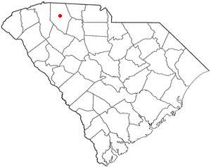
Chester County is a county located in the U.S. state of South Carolina. As of the 2020 census, its population was 32,294. Its county seat is Chester.

<span class="mw-page-title-main">Chuluota, Florida</span> CDP in Florida, United States

Chuluota is a census-designated place and an unincorporated area in Seminole County, Florida, United States. The population was 2,524 at the 2020 Census. It is part of the Orlando–Kissimmee Metropolitan Statistical Area.

<span class="mw-page-title-main">Midway, Seminole County, Florida</span> CDP in Florida, United States

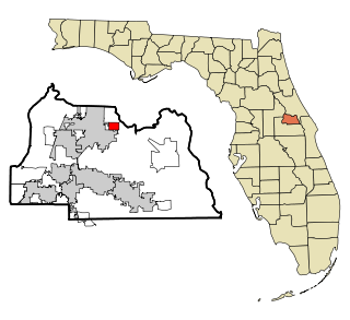
Midway is a census-designated place and an unincorporated area in Seminole County, Florida, United States. The population was 1,714 at the 2000 census. It is part of the Orlando–Kissimmee–Sanford Metropolitan Statistical Area.

<span class="mw-page-title-main">Laupāhoehoe, Hawaii</span> Census-designated place in Hawaii, U.S.

Laupāhoehoe is a census-designated place (CDP) in Hawaiʻi County, Hawaii, United States, in the District of North Hilo. The population was 581 at the 2010 census, up from 473 at the 2000 census. The community's name means "lava tip" and refers to the angular lava tip or cape formed by ancient pāhoehoe flows which created the cape on which the community was built.

<span class="mw-page-title-main">Yarmouth Port, Massachusetts</span> Census-designated place in Massachusetts, United States

Yarmouth Port is a census-designated place (CDP) in the town of Yarmouth in Barnstable County, Massachusetts, United States. The population was 5,320 at the 2010 census.

<span class="mw-page-title-main">Saxapahaw, North Carolina</span> Census-designated place in North Carolina, United States

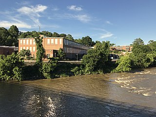
Saxapahaw is a census-designated place (CDP) and unincorporated area in Alamance County, North Carolina, United States. It is part of the Burlington, North Carolina Metropolitan Statistical Area. The population was 1,648 at the 2010 census.

<span class="mw-page-title-main">Forest Oaks, North Carolina</span> Census-designated place in North Carolina, United States

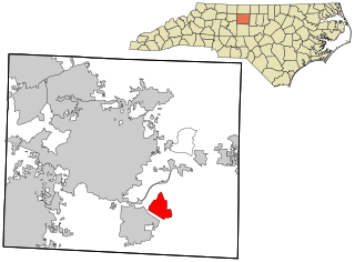
Forest Oaks is a census-designated place (CDP) in Guilford County, North Carolina, United States. The population was 3,890 as of the 2010 census, up from 3,241 in 2000.

<span class="mw-page-title-main">Eureka Mill, South Carolina</span> Census-designated place in South Carolina, United States

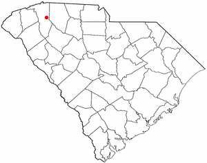
Eureka Mill is a census-designated place (CDP) in Chester County, South Carolina, United States. The population was 1,476 at the 2010 census, down from 1,737 at the 2000 census.

<span class="mw-page-title-main">Winnsboro Mills, South Carolina</span> Census-designated place in South Carolina, United States

Winnsboro Mills is an unincorporated community and census-designated place (CDP) in Fairfield County, South Carolina, United States. The population was 1,898 at the 2010 census, down from 2,263 at the 2000 census. It is part of the Columbia, South Carolina Metropolitan Statistical Area.

Dunean is a census-designated place (CDP) in Greenville County, South Carolina, United States. The population was 3,671 at the 2010 census, down from 4,158 in 2000. It is part of the Greenville–Mauldin–Easley Metropolitan Statistical Area.

<span class="mw-page-title-main">Taylors, South Carolina</span> CDP in South Carolina, United States

Taylors is a census-designated place (CDP) in Greenville County, South Carolina, United States. The population was 21,617 at the 2010 census. Taylors is the Greenville/Spartanburg area's largest suburb although it is not incorporated as a city. It is part of the Greenville–Mauldin–Easley Metropolitan Statistical Area. The area serves as the result of urban sprawl in the Greenville metropolitan city.

<span class="mw-page-title-main">Socastee, South Carolina</span> CDP in South Carolina, United States

Socastee is a census-designated place (CDP) in Horry County, South Carolina, United States. The population was 19,952 at the 2010 census.

<span class="mw-page-title-main">Watts Mills, South Carolina</span> Census-designated place in South Carolina, United States

Wattsville is an unincorporated community in Laurens County, South Carolina, United States. The town name is derived from Watts Mill, a textile mill in the center of town. The area is listed as the Wattsville census-designated place (CDP) for statistical purposes. The population of the CDP was 1,635 at the 2010 census. It is part of the Greenville–Mauldin–Easley Metropolitan Statistical Area.

Seven Oaks is a census-designated place (CDP) in Lexington County, South Carolina, United States, 8 miles (13 km) northwest of downtown Columbia, the state capital. The population of the CDP was 15,144 at the 2010 census. It is part of the Columbia Metropolitan Statistical Area.

<span class="mw-page-title-main">Roebuck, South Carolina</span> CDP in South Carolina, United States

Roebuck is a census-designated place (CDP) in Spartanburg County, South Carolina, United States. The population was 2,200 at the 2010 census.

<span class="mw-page-title-main">Saxon, South Carolina</span> CDP in South Carolina, United States

Saxon is a census-designated place (CDP) in Spartanburg County, South Carolina, United States. The population was 3,424 at the 2010 census.

Southern Shops is a census-designated place (CDP) in Spartanburg County, South Carolina, United States. The population was 3,767 at the 2010 census.

<span class="mw-page-title-main">Startex, South Carolina</span> CDP in South Carolina, United States

Startex is a census-designated place (CDP) in Spartanburg County, South Carolina, United States. The population was 859 at the 2010 census. The area was originally known as Tucapau, named after the mill that was built there in 1896. In 1936, Walter Montgomery Sr. bought the mill and changed its name to Startex—the brand name of household textiles produced at the plant. The mill ceased operations in 1998 and was mostly dismantled in 1999.

<span class="mw-page-title-main">Buffalo, South Carolina</span> CDP in South Carolina, United States

Buffalo is a census-designated place (CDP) in Union County, South Carolina, United States. The population was 1,266 at the 2010 United States Census.

<span class="mw-page-title-main">Monarch Mill, South Carolina</span> CDP in South Carolina, United States

Monarch Mill is a census-designated place (CDP) in Union County, South Carolina, United States. The population was 1,811 at the 2010 census.

References

  1. "ArcGIS REST Services Directory". United States Census Bureau. Retrieved October 15, 2022.
  2. 1 2 U.S. Geological Survey Geographic Names Information System: Gayle Mill, South Carolina
  3. "Census Population API". United States Census Bureau. Retrieved Oct 15, 2022.
  4. "Gayle Mill SC ZIP Code". zipdatamaps.com. 2023. Retrieved February 17, 2023.
  5. 1 2 "U.S. Census website". United States Census Bureau . Retrieved 2008-01-31.
  6. 1 2 "Geographic Identifiers: 2010 Census Summary File 1 (G001): Gayle Mill CDP, South Carolina". U.S. Census Bureau, American Factfinder. Archived from the original on February 13, 2020. Retrieved July 1, 2015.
  7. "US Gazetteer files: 2010, 2000, and 1990". United States Census Bureau. 2011-02-12. Retrieved 2011-04-23.
  8. "Census of Population and Housing". Census.gov. Retrieved June 4, 2016.