South First Street Bridge

Last updated
South First Street Bridge
AustinSkyline3.jpeg
Coordinates 30°15′46″N97°44′53″W / 30.2628°N 97.748°W
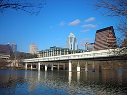
 / 30.2628; -97.748
Locale Austin, Texas, United States
Location
South First Street Bridge

The South First Street Bridge (sometimes simply the First Street Bridge) [1] is a bridge in Austin, Texas, United States. [2]

Related Research Articles

<span class="mw-page-title-main">Austin, Texas</span> Capital city of Texas

Austin is the capital of the U.S. state of Texas and the county seat and most populous city of Travis County, with portions extending into Hays and Williamson counties. Incorporated on December 27, 1839, it is the 11th-most populous city in the United States, the fourth-most populous city in the state after Dallas, San Antonio, and Houston, and the second-most populous state capital city after Phoenix, the capital of Arizona. It has been one of the fastest growing large cities in the United States since 2010. Downtown Austin and Downtown San Antonio are approximately 80 miles (129 km) apart, and both fall along the Interstate 35 corridor. This combined metropolitan region of San Antonio–Austin has approximately 5 million people. Austin is the southernmost state capital in the contiguous United States and is considered a Gamma-level global city as categorized by the Globalization and World Cities Research Network.

<span class="mw-page-title-main">Interstate 90</span> Interstate Highway across northern United States

Interstate 90 (I-90) is an east–west transcontinental freeway and the longest Interstate Highway in the United States at 3,021 miles (4,862 km). It begins in Seattle, Washington, and travels through the Pacific Northwest, Mountain West, Great Plains, Midwest, and the Northeast, ending in Boston, Massachusetts. The highway serves 13 states and has 15 auxiliary routes, primarily in major cities such as Chicago, Cleveland, Buffalo, and Rochester.

<span class="mw-page-title-main">Lady Bird Lake</span> Reservoir in Austin, Texas, US

Lady Bird Lake is a river-like reservoir on the Colorado River in Austin, Texas, United States. The City of Austin created the reservoir in 1960 as a cooling pond for a new city power plant. The lake, which has a surface area of 416 acres (168 ha), is now used primarily for recreation and flood control. The reservoir is named in honor of former First Lady of the United States Lady Bird Johnson.

<span class="mw-page-title-main">Austin–Bergstrom International Airport</span> Civilian airport serving Austin, Texas, United States

Austin–Bergstrom International Airport, or ABIA, is an international airport in Austin, Texas, United States, serving the Greater Austin metropolitan area. Located about 5 miles southeast of downtown Austin, it covers 4,242 acres (1,717 ha) and has two runways and three helipads.

<span class="mw-page-title-main">Sixth Street (Austin, Texas)</span> United States historic place

Sixth Street is a historic street and entertainment district in Austin, Texas, located within the city's urban core in downtown Austin. Sixth Street was formerly named Pecan Street under Austin's older naming convention, which had east–west streets named after trees and north–south streets named after Texas rivers.

<span class="mw-page-title-main">South Brisbane, Queensland</span> Suburb of Brisbane, Queensland, Australia

South Brisbane is an inner southern suburb in the City of Brisbane, Queensland, Australia. In the 2021 census, South Brisbane had a population of 14,292 people.

<span class="mw-page-title-main">Broadway Bridge (Manhattan)</span> Bridge in New York City

The Broadway Bridge is a vertical-lift bridge across the Harlem River Ship Canal in the borough of Manhattan in New York City. It connects the neighborhoods of Inwood on Manhattan Island and Marble Hill on the mainland. The bridge consists of two decks. The lower deck carries Broadway, which is designated as U.S. Route 9 at this location. The upper deck carries the New York City Subway's IRT Broadway–Seventh Avenue Line, serving the 1 train.

<span class="mw-page-title-main">Texas State Highway Loop 1</span> Highway in Texas

Loop 1 is a freeway which provides access to the west side of Austin in the U.S. state of Texas. It is named Mopac Expressway after the Missouri Pacific Railroad. Local residents almost always use the name "MoPac" rather than calling the road by its number, which can cause much confusion, for few signs along the road use this name.

<span class="mw-page-title-main">Congress Avenue Historic District</span> Historic district in Texas, United States

Congress Avenue is a major thoroughfare in Austin, Texas. The street is a six-lane, tree lined avenue that cuts through the middle of the city from far south Austin and goes over Lady Bird Lake leading to the Texas State Capitol in the heart of Downtown.

The Capital Metropolitan Transportation Authority, officially stylized as CapMetro, is a public transportation provider located in Austin, Texas. It operates bus, paratransit services and a hybrid rail system known as CapMetro Rail in Austin and several suburbs in Travis and Williamson counties. In 2023, the system had a ridership of 25,229,400, or about 81,200 per weekday as of the first quarter of 2024.

<span class="mw-page-title-main">CapMetro Rail</span> Hybrid rail system in Austin, Texas

CapMetro Rail is a hybrid rail system that serves the Greater Austin area in Texas and is owned by CapMetro, Austin's primary public transportation provider. The Red Line is CapMetro's first and currently only rail line, and connects Downtown Austin with Austin's northwestern suburbs. The line operates on 32 miles (51 km) of existing freight tracks, and serves 10 stations. After a series of delays, CapMetro Rail was inaugurated in March 2010. CapMetro added Friday evening and Saturday afternoon and evening regularly scheduled service on March 23, 2012. In 2023, the line had a ridership of 485,400, or about 1,800 per weekday as of the first quarter of 2024.

<span class="mw-page-title-main">Brisbane central business district</span> Suburb of Brisbane, Queensland, Australia

Brisbane City is the central suburb and central business district of Brisbane, the state capital of Queensland, Australia. It is colloquially referred to as the "Brisbane CBD" or "the city". It is located on a point on the northern bank of the Brisbane River, historically known as Meanjin, Mianjin or Meeanjin in the local Aboriginal Australian dialect. The triangular shaped area is bounded by the median of the Brisbane River to the east, south and west. The point, known at its tip as Gardens Point, slopes upward to the north-west where the city is bounded by parkland and the inner city suburb of Spring Hill to the north. The CBD is bounded to the north-east by the suburb of Fortitude Valley. To the west the CBD is bounded by Milton, Petrie Terrace, and Kelvin Grove.

<span class="mw-page-title-main">Canal Street station (New York City Subway)</span> New York City Subway station in Manhattan

The Canal Street station is a New York City Subway station complex. It is located in the neighborhoods of Chinatown and SoHo in Manhattan and is shared by the BMT Broadway Line, the IRT Lexington Avenue Line, and the BMT Nassau Street Line. It is served by the 6, J, N, and Q trains at all times; the R train at all times except late nights; the W train during weekdays; the <6> train during weekdays in the peak direction; the Z train during rush hours in the peak direction; and the 4 train during late nights.

<span class="mw-page-title-main">Lamar Boulevard Bridge</span> Historic bridge in Austin, Texas

The Lamar Boulevard Bridge is a historic arch bridge carrying Texas State Highway Loop 343 over Lady Bird Lake in downtown Austin, Texas, United States. The bridge features six open-spandrel concrete arches spanning 659 feet (201 m) and carries tens of thousands of vehicles daily across the lake. Completed in 1942, the Lamar Boulevard Bridge was the second permanent bridge to cross the Colorado River, and one of the last Art Deco-style open-spandrel concrete arch bridges built in Texas. The bridge was named an Austin Landmark in 1993 and added to the National Register of Historic Places in 1994.

<span class="mw-page-title-main">U.S. Route 183 in Texas</span> Highway in Texas

U.S. Route 183 (US 183) is a north-south U.S. highway that begins in Texas in Refugio at an intersection with US 77 concurrent with US 77 Alt. The highway runs through many small communities with Austin being the only major city along its route. The highway exits Texas concurrent with US 70, crossing into Oklahoma.

<span class="mw-page-title-main">Interstate 35 in Texas</span> Section of Interstate Highway in Texas, United States

Interstate 35 (I-35) is a major north–south Interstate Highway that runs from Laredo, Texas near the Mexican border to Duluth, Minnesota. In Texas, the highway begins in Laredo and runs north to the Red River north of Gainesville, where it crosses into Oklahoma. Along its route, it passes through the cities of San Antonio, Austin, and Waco before splitting into two branch routes just north of Hillsboro: I-35E heads northeast through Dallas, while I-35W turns northwest to run through Fort Worth. The two branches rejoin in Denton to again form I-35, which continues to the Oklahoma state line. The exit numbers for I-35E maintain the sequence of exit numbers from the southern segment of I-35, and the northern segment of I-35 follows on from the sequence of exit numbers from I-35E. I-35W maintains its own sequence of exit numbers.

<span class="mw-page-title-main">Montopolis, Austin, Texas</span> Neighborhood in Austin, Texas, United States

Travis County has had two locations named Montopolis. The first was during the Republic of Texas period north of the Colorado River. The second is today's Montopolis neighborhood in Austin, Texas south of the river. Located southeast of the city's urban core, today's neighborhood is in ZIP code 78741. Montopolis is bounded by Lake Lady Bird on the north, by Grove Street and the Pleasant Valley neighborhood on the west, to the south by Texas State Highway 71, and by U.S. Route 183 on the east. The southeast corner abuts Austin-Bergstrom International Airport. Montopolis is in City Council District 3.

<span class="mw-page-title-main">MacArthur Bridge (Manila)</span> Road bridge in Manila, Philippines

The MacArthur Bridge is a road bridge crossing the Pasig River between Padre Burgos Avenue in Ermita and the intersection of Plaza Santa Cruz Road, Carriedo Street, Palanca Street, and Escolta Street in Santa Cruz. It replaced the Santa Cruz Bridge, which was destroyed during World War II. The bridge is named after General Douglas MacArthur, whose military operations led to the liberation of the Philippines during World War II.

The Blue Line is a planned light rail line for connecting Austin–Bergstrom International Airport with downtown Austin, Texas. It is still in the planning stages as a part of CapMetro's Project Connect. It is estimated to begin revenue service as early as 2029.

<span class="mw-page-title-main">Third Street Railroad Trestle</span> Historic railroad bridge in downtown Austin, Texas

The Third Street Railroad Trestle is a historic wooden railroad trestle bridge crossing Shoal Creek in downtown Austin, Texas. Built around 1922 by the International–Great Northern Railroad, it replaced an earlier bridge in the same place. The bridge was used by the I–GN Railroad, the Missouri Pacific Railroad, and the Missouri–Kansas–Texas Railroad until 1964, when commercial rail traffic stopped; after 1991 the bridge was abandoned. It was added to the National Register of Historic Places in 2021.

References

  1. "Trail under First Street Bridge to be transformed with major project". 27 May 2019. Archived from the original on 9 July 2021. Retrieved 2 July 2021.
  2. "Construction of South First street bridge". Austin American-Statesman. 7 July 1953. p. 13. Archived from the original on 9 July 2021. Retrieved 2 July 2021.