
Algonquin is a village in McHenry and Kane counties, Illinois, in the United States. It is a suburb of Chicago, located approximately 40 miles (64 km) northwest of the Loop. As of the 2020 census, the village's population was 29,700.

Middletown is the largest city in Orange County, New York, United States. It lies in New York's Hudson Valley region, near the Wallkill River and the foothills of the Shawangunk Mountains. Middletown is situated between Port Jervis and Newburgh, New York. At the 2020 United States census, the city's population was 30,345, reflecting an increase of 2,259 from the 28,086 counted in the 2010 census. The zip code is 10940. Middletown falls within the Poughkeepsie–Newburgh–Middletown Metropolitan Statistical Area, which belongs to the larger New York–Newark–Bridgeport, NY–NJ–CT–PA Combined Statistical Area.
Minot is a city in and the county seat of Ward County, North Dakota, United States, in the state's north-central region. It is most widely known for the Air Force base approximately 15 miles (24 km) north of the city. With a population of 48,377 at the 2020 census, Minot is the state's fourth-most populous city and a trading center for a large part of northern North Dakota, southwestern Manitoba, and southeastern Saskatchewan. Founded in 1886 during the construction of James J. Hill's Great Northern Railway, Minot is also known as "Magic City", commemorating its remarkable growth in size over a short time.

West Seattle is a conglomeration of neighborhoods in Seattle, Washington, United States. It comprises two of the thirteen districts, Delridge and Southwest, and encompasses all of Seattle west of the Duwamish River. It was incorporated as an independent town in 1902 before being annexed by Seattle five years later. Among the area's attractions are its saltwater beach parks along Elliott Bay and Puget Sound, including Alki Beach Park and Lincoln Park. The area is also known for its views of the Olympic Mountains to the west and the Cascade Range to the east. One-third of Seattle's green space and urban forest is located in West Seattle, much of it in the West Duwamish Greenbelt.

The Community Connector is a municipally owned bus system connecting Bangor, Maine, with outlying towns, including Veazie, Orono, Old Town, Brewer, and Hampden. The system is owned and operated by the City of Bangor.

Downtown Portland is the central business district of Portland, Oregon, United States. It is on the west bank of the Willamette River in the northeastern corner of the southwest section of the city and where most of the city's high-rise buildings are found.

The Hillsdale district is a neighborhood in the southwest section of Portland, Oregon, United States. It is centered on the Hillsdale retail and business area, a series of strip malls on SW Capitol Highway between SW Sunset Boulevard and SW Bertha Boulevard. It is home to the Hillsdale Farmer's Market, which takes place on Sundays during the summer and every other Sunday during the winter. Hillsdale is also home to Oregon's first brewpub, with the opening of McMenamins Hillsdale Brewery in 1985.
Minot City Transit, is the public transit agency operated in Minot, North Dakota, It operates fixed-route bus routes in the city.
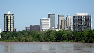
Tulsa is the second-largest city in the state of Oklahoma. It has many diverse neighborhoods due to its size.
The following is a list of neighborhoods and commercial districts in Sioux City, Iowa.
The geography of Minot, North Dakota is treated extensively in this article.

The city of Billings, Montana is subdivided into 11 sections for geographic and planning purposes.
The streets of Albany, New York have had a long history going back almost 400 years. Many of the streets have changed names over the course of time, some have changed names many times. Some streets no longer exist, others have changed course. Some roads existed only on paper. The oldest streets were haphazardly laid out with no overall plan until Simeon De Witt's 1794 street grid plan. The plan had two grids, one west of Eagle Street and the old stockade, and another for the Pastures District south of the old stockade.

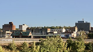
Downtown Minot is the central business district of Minot, North Dakota, located south of the Souris River in the Souris Valley. Downtown is the site of the first permanent settlement in Minot in 1886. Downtown is home to many of Minot's cultural sites of interest. It is also home to numerous galleries, stores and restaurants. The Minot Riverwalk traverses the downtown.

Bel Air is a neighborhood in Minot, North Dakota, located in the Souris River Valley. It is roughly bound by North Hill to the north, Sixteenth Street NW to the east, Fourth Avenue NW to the south and the city limits on the west. The neighborhood was home to about a thousand people in 2010. The neighborhood is home to Bel Air Elementary School on Twenty Fifth Street NW. The neighborhood was developed as the Bel Air Addition in 1956. Fourth Avenue is home to a number of businesses in Bel Air, many of which were severely damaged in the Souris River flood in 2011. Bel Air is home to the Church of the Living God, the Bible Fellowship Church and the Christ Lutheran Church.

North Hill is a neighborhood in Minot, North Dakota, one of three major areas of the city, others being The Valley and South Hill, It is located north of the Souris River, above the Souris River Valley. It is a primarily residential neighborhood, though there are industries and businesses in the area, primarily along North Broadway and 21st Ave NW. North Hill is also home to Minot International Airport.

Upper Brooklyn or Brooklyn Heights is a neighborhood on South Hill in Minot, North Dakota. The neighborhood consists of the sections of the Brooklyn Addition that are not part of Downtown Minot. The High Third neighborhood, the Lower Brooklyn neighborhood and the area around the Minot Municipal Auditorium, which were part of the Brooklyn Addition, are considered part of the downtown area. Upper Brooklyn is bordered by downtown and the BNSF railroad tracks to the north, Minot High School's Magic City Campus to the west, Eleventh Avenue SW to the south and South Broadway and Lower Brooklyn to the east. The neighborhood is approximately 0.46 square kilometers. The neighborhood is home to the Scandinavian Heritage Park and Jim Hill Middle School.
West Oaks is a neighborhood in Minot, North Dakota. The neighborhood is bounded by Oak Park to the North, the Souris River to the east, the Soo Line Railroad tracks to the south and Sixteenth Street SW. The neighborhood is home to the West Oaks Animal Hospital, the West Oaks Apartments, Harleys Automotive Center and gas station, Eagles Wings Community Fellowship and a number of single family homes. Oak Park's south entrance is located in the neighborhood on Oak Drive SW. A thin strip of land between the Oak Park Oxbow and the Souris River connects the park with the neighborhood. The neighborhood was greatly impacted by the Souris River flood in 2011. In June 2011, the Washington Post printed a story about the Minot flood on the front page with an accompanying photograph of Harleys and the nearby Arrowhead Mall. Water inundated both structures, despite the large dikes constructed around both buildings. On June 26, 2011, the New York Times also printed an article with an aerial photograph of the flooded Harleys. Similar aerial photographs of the flood at that location are displayed at the Harleys gas station.


