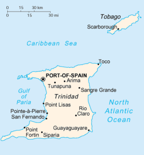
Trinidad is the larger and more populous of the two major islands of Trinidad and Tobago. The island lies 11 km (6.8 mi) off the northeastern coast of Venezuela and sits on the continental shelf of South America. It is often referred to as the southernmost island in the Caribbean. With an area of 5,131 km2 (1,981 sq mi), it is also the fifth largest in the West Indies.
San Fernando, officially the City of San Fernando, is the most populous city and second most populous municipality in Trinidad and Tobago, after Chaguanas. Sando, as it is also known, occupies 19 km² and is located in the southwestern part of the island of Trinidad. It is bounded to the north by the Guaracara River, the south by the Oropouche River, the east by the Sir Solomon Hochoy Highway, and the west by the Gulf of Paria. The former borough was elevated to the status of a city corporation on 18 November 1988. The motto of San Fernando is: "Sanitas Fortis" - In a Healthy Environment We Will Find Strength. Many local Trinidadians refer to the city with the shortened name "Sando." San Fernando is called Trinidad and Tobago's "industrial capital" because of its proximity to the Pointe-à-Pierre oil refinery and many other petrochemical, LNG, iron and steel and aluminium smelters in places such as Point Lisas in Couva, Point Fortin, and La Brea.
Penal is a town in south Trinidad, Trinidad and Tobago. It lies south of San Fernando, Princes Town, and Debe, and north of Moruga and Siparia. It was originally a rice- and cocoa-producing area but is now a rapidly expanding and developing town. The population is 12,281.

Hinduism is the second largest religion in Trinidad and Tobago. Hindu culture arrived in 1845 in Trinidad and Tobago. In the 2011 census, There are 240,100 declared Hindus in Trinidad and Tobago. There are also various temples in Trinidad and Tobago to accommodate Hindus.

Oropouche fever is a tropical viral infection transmitted by biting midges and mosquitoes from the blood of sloths to humans. This disease is named after the region where it was first discovered and isolated at the Trinidad Regional Virus Laboratory in 1955 by the Oropouche River in Trinidad and Tobago. Oropouche fever is caused by a specific arbovirus, the Oropouche virus (OROV), of the Bunyaviridae family.
Oropouche orthobunyavirus (OROV) is one of the most common orthobunyaviruses. When OROV infects humans, it causes a rapid fever illness called Oropouche fever. OROV was originally reported in Trinidad and Tobago in 1955 from the blood sample of a fever patient and from a pool of Coquillettidia venezuelensis mosquitoes. In 1960, OROV was isolated from a sloth and a pool of Ochlerotatus serratus mosquitoes in Brazil. The virus is considered a public health threat in tropical and subtropical areas of Central and South America, with over half million infected people as of 2005. OROV is considered to be an arbovirus due to the method of transmission by the mosquitoes Aedes serratus and Culex quinquefasciatus among sloths, marsupials, primates, and birds.

Penal–Debe region is a region of Trinidad. The local government body is Penal–Debe Regional Corporation, a Regional Corporation of Trinidad and Tobago. The region has a land area of 246.91 km². Urban areas within Penal–Debe include Penal, where the corporation is headquartered, and Debe. Electoral Districts within Penal–Debe Regional Corporation are:

Siparia is a region of Trinidad and Tobago in the southwestern portion of the island. The Region of Siparia is a Regional Corporation, which handles local government functions. The Siparia Regional Corporation is headquartered in Siparia. Other urban areas include Cedros, Fyzabad, La Brea, Santa Flora, South Oropouche.
The Navet Dam is one of the major reservoirs supplying potable water in Trinidad and Tobago. It is located in Tabaquite, Trinidad and Tobago and is managed by the Water and Sewerage Authority of Trinidad and Tobago. The dam was completed in 1962, expanded in 1966 and 1976. It supplies Tabaquite, Brasso, Gran Couva, Williamsville, Gasparillo, Whiteland San Fernando, Debe, Penal, Princes Town, Rio Claro, South Oropouche, La Brea, Moruga, New Grant, Plaisance Park, La Romaine and Fyzabad.

SM Jaleel & Company Ltd, also known as SMJ, is the largest manufacturer of non alcoholic drinks in the English speaking Caribbean. Since inception in 1924 their portfolio of beverages are distributed to over 60 countries worldwide.

General elections were held in Trinidad and Tobago on 5 November 2007. Nomination day was 15 October.
In 2012, the government of Trinidad and Tobago approved the introduction of postal codes starting later that same year. In addition to the postal code implementation the country has embarked on a nationwide address improvement initiative adopting the Universal Postal Union (UPU) S-42 international standard of addressing. The UPU is an arm of the United Nations and is the coordinating body of postal services worldwide. The intent of this exercise is to correct poor addressing in Trinidad & Tobago and assign to each address a six-digit postal code. This change will result in the following:
Oropouche or Oropuche can refer to:
The Church of the Nazarene in Trinidad and Tobago is a part of the international Church of the Nazarene.
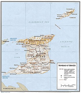
On the island of Trinidad, the Naparima Plain is a broad lowland area on the west between the Central Range and the Southern Range ; the lowland area on the east is the Nariva Plain. To the north of the Central Range is the Caroni Plain. The Oropouche river flows through the Naparima Plain and drains into the Oropouche Lagoon, a swampy area, on the Gulf of Paria coast. The northern region of the Naparima Plain has alluvial soil; the southern region is sandy and less fertile.
Roodal Moonilal was the Minister of Housing and Urban Development of Trinidad and Tobago and the Leader of Government Business in the Lower House of Parliament from 2010 to 2015. Moonilal has been the Member of Parliament for Oropouche East since 2010, and served as the Member of Parliament for Oropouche from 2002–2007. Moonilal is a founding member of the United National Congress, in fact he served as the first Youth Affairs Officer of the Party.

The Oropouche Formation is a geologic formation in Trinidad and Tobago dating to the Pleistocene. It preserves plant fossils.
