Deerhurst is a village and civil parish in Gloucestershire, England, about 2 miles (3 km) southwest of Tewkesbury. The village is on the east bank of the River Severn. The parish includes the village of Apperley and the hamlet of Deerhurst Walton. The 2011 Census recorded the parish's population as 906, the majority of whom live in Apperley.

Harwell is a village and civil parish in the Vale of White Horse about 2 miles (3 km) west of Didcot, 6 miles (10 km) east of Wantage and 13 miles (21 km) south of Oxford, England. The parish measures about 3.5 miles (6 km) north – south, and almost 2 miles (3 km) east – west at its widest point. In 1923 its area was 2,521 acres (1,020 ha). Historically in Berkshire, it has been administered as part of Oxfordshire since the 1974 boundary changes. The parish includes part of Harwell Science and Innovation Campus in the southwest. The 2011 census recorded the parish's population as 2,349.

Long Eaton is a town in the Erewash district of Derbyshire, England, just north of the River Trent, about 6 miles (9.7 km) south-west of Nottingham and 9 miles (14 km) south-east of Derby. The town population was 37,760 at the 2011 census. It has been part of Erewash borough since 1 April 1974, when Long Eaton Urban District was disbanded.

The Park Estate is a private residential housing estate to the west of Nottingham city centre, England. It is noted for its Victorian architecture, although many of the houses have been altered, extended or converted into flats. The estate uses gas street lighting, which is believed to be one of the largest networks in Europe.

Soho Square is a garden square in Soho, London, hosting since 1954 a de facto public park let by the Soho Square Garden Committee to Westminster City Council. It was originally called King Square after Charles II, and a much weathered statue of the monarch has stood in the square, with an extended interruption, since 1661, one year after the restoration of the monarchy.
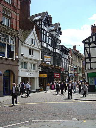
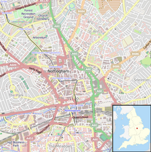
Bridlesmith Gate is a pedestrianised shopping street in the city centre of Nottingham, England. It is located between Middle Pavement and Victoria Street. St. Peter's Gate and Bottle Lane stem off it along with Byard Lane.

The Westport Canal was built in the late 1830s to link Westport and Langport in Somerset, England. It was part of a larger scheme involving improvements to the River Parrett above Burrow Bridge. Langport is the point at which the River Yeo joins the River Parrett and the intention was to enable trade via the port at Bridgwater. It remained in use until the 1870s, but closed when the Somerset Drainage Commissioners took over control of the River Parrett. Despite a petition against closure by local people, the Commissioners ruled that navigation of the canal must cease due to their interpretation of the Act which gave them control of it, leaving the canal to serve as a drainage channel since 1878.
Thomas Cecil Howitt, OBE was a British provincial architect of the 20th Century. Howitt is chiefly remembered for designing prominent public buildings, such as the Council House and Processional Way in Nottingham, Baskerville House in Birmingham, Newport Civic Centre, and several Odeon cinemas. Howitt's chief architectural legacies are in his home city of Nottingham. He was Housing Architect for the City Council, designing municipal housing estates which are often considered to be among the finest in terms of planning in the country.

Corn Street, together with Broad Street, Wine Street and High Street, is one of the four cross streets which met at the Bristol High Cross, the heart of Bristol, England when it was a walled medieval town. From this crossroads Corn Street and its later extension Clare Street runs downhill approximately 325m south-westwards to The Centre.

The Old Punch Bowl is a medieval timber-framed Wealden hall house on the High Street in Crawley, a town and borough in West Sussex, England. Built in the early 15th century, it was used as a farmhouse by about 1600, passing through various owners and sometimes being used for other purposes. Since 1929 it has been in commercial use—firstly as a tearoom, then as a bank, and since 1994 as a public house. When built, it was one of at least five similar hall houses in the ancient parish of Crawley; it is now one of the oldest and best-preserved buildings in Crawley town centre.

Bath and North East Somerset is a unitary authority created on 1 April 1996, following the abolition of the County of Avon, which had existed since 1974. Part of the ceremonial county of Somerset, Bath and North East Somerset occupies an area of 220 square miles (570 km2), two-thirds of which is green belt. It stretches from the outskirts of Bristol, south into the Mendip Hills and east to the southern Cotswold Hills and Wiltshire border. The city of Bath is the principal settlement in the district, but BANES also covers Keynsham, Midsomer Norton, Radstock and the Chew Valley. The area has a population of 170,000, about half of whom live in Bath, making it 12 times more densely populated than the rest of the area.

Fore Street in Chard, Somerset, England was built in the late 16th and early 17th century, following a fire which destroyed much of the town in 1577.

Bromley House Library is a subscription library in Nottingham, England.
Tattenhall is a former civil parish, now in the parish of Tattenhall and District, in Cheshire West and Chester, England. It contains 27 buildings that are recorded in the National Heritage List for England as designated listed buildings. Of these, three are listed at Grade II*, the middle grade, and the others are at Grade II, the lowest grade. Apart from the village of Tattenhall, the parish is rural. In the village the listed buildings include the church and its sundial, the war memorial, and houses and cottages, some dating from the 17th century and with a timber-framed core. Outside the village, the listed buildings include country houses and associated structures, other houses and cottages, farmhouses, and a boundary stone.

Robert Evans FRIBA, JP was an English architect based in Nottingham.

William Jolley was an English architect based in Nottingham.
Manchester is a city in Northwest England. The M2 postcode area of the city includes part of the city centre, including the Central Retail District. The postcode area contains 143 listed buildings that are recorded in the National Heritage List for England. Of these, five are listed at Grade I, the highest of the three grades, 16 are at Grade II*, the middle grade, and the others are at Grade II, the lowest grade.

Stoney Street is an historic street in Nottingham City Centre between High Pavement and Carlton Street.

Wheeler Gate is a street in Nottingham City Centre between Old Market Square and St Peter’s Square.

Whitefriargate is a pedestrianised street in the Old Town area of Kingston upon Hull, in the East Riding of Yorkshire, England. During the 20th century, it was one of the main shopping streets in the city centre, but some of the major stores have closed down, which has been attributed to out of town shopping centres. However, the Street still provides a useful link to and from the old town of Hull.