
The Wilsons Promontory National Park, commonly known as Wilsons Prom or The Prom, is a national park in the Gippsland region of Victoria, Australia, located approximately 157 kilometres (98 mi) southeast of Melbourne.

Bass Strait is a strait separating the island state of Tasmania from the Australian mainland. The strait provides the most direct waterway between the Great Australian Bight and the Tasman Sea, and is also the only maritime route into the economically prominent Port Phillip Bay.

The Tidal River is a perennial river of the West Gippsland catchment, located in the Wilsons Promontory region of the Australian state of Victoria. A permanent camping ground which the river flows passed to the south is also called Tidal River.

South East Point lies on the southerly tip of Wilsons Promontory, Victoria, Australia. South East Point is located at 39°07′S146°25′E. It commands sensational views of Bass Strait and is a major landmark for all ships travelling between the southern Australian ports and the Pacific Ocean. South East Point is the site of the Wilsons Promontory Lighthouse. The only access for visitors is a full day hike from the Tidal River camping ground.

Wilsons Promontory Lighthouse is situated on South East Point, Wilsons Promontory, Victoria, Australia. From its point on the peninsula, it commands almost 360° views of Bass Strait. The Wilson's Promontory lighthouse is the southernmost lighthouse on mainland Australia, and is approximately 18 kilometres (11 mi) from the nearest town, Tidal River. Dormitory-style accommodation is available in the lighthouse.
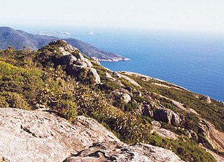
Wilsons Promontory, is a peninsula that forms the southernmost part of the Australian mainland, located in the state of Victoria.

Cape Barren Island, officially truwana / Cape Barren Island, is a 478-square-kilometre (185 sq mi) island in the Bass Strait, off the north east coast of Tasmania, Australia. It is the second largest island of the Furneaux Group; Flinders Island lies to the north, with the smaller Clarke Island to the south. The highest point on the island is Mount Munro at 715 metres (2,346 ft). Mount Munro is probably named after James Munro, a former convict and then sealer, who lived from the 1820s for more than 20 years with several women on nearby Preservation Island.

Cape Liptrap is located in south Gippsland, Victoria and is a peninsula that is the extension of the Hoddle Range that runs out to sea in a southwesterly direction. With a latitude of 38° 53' 60" S it the second most southerly point on the Australian mainland, just south of Cape Otway which lies to the west. Wilsons Promontory which is the most southerly point sits to the southeast separated from Cape Liptrap by Waratah Bay.

South Gippsland, a region of Gippsland in Victoria, Australia, is a well-watered region consisting of low, rolling hills descending to the coast in the south and the Latrobe Valley in the north. Low granite hills continue into Wilsons Promontory, the southernmost point of Victoria and mainland Australia. Rivers are generally very short and impossible to dam owing to the lack of potential storage sites, but groundwater of good quality is readily available. The major industries are forestry and dairy farming, and the principal towns include Cowes, Leongatha, Korumburra, Wonthaggi and Foster.
Banksia Creek is a watercourse in Victoria. It is located at 39°07′S146°22′E at the southern tip of Wilsons Promontory. The name refers to the plant genus Banksia, which grows in the area.
Yanakie Isthmus is a sandy isthmus that connects Wilsons Promontory to mainland Victoria, south-eastern Australia. The small holiday town of Sandy Point and nearby Shallow Inlet lie on the western side of the isthmus.

The electoral district of Gippsland South is a Lower House electoral district of the Victorian Parliament. It is located within the Eastern Victoria Region of the Legislative Council.

Curtis Island is a granite island, with an area of 150 ha, in south-eastern Australia. It is part of Tasmania’s Curtis Group, lying in northern Bass Strait between the Furneaux Group and Wilsons Promontory in Victoria. It is a nature reserve and has been identified as an Important Bird Area because it supports up to 390,000 breeding pairs of short-tailed shearwaters or Tasmanian muttonbirds.
Cone Islet is a small granite island, with an area of 4.82 ha, in south-eastern Australia. It is part of Tasmania’s Curtis Group, lying in northern Bass Strait between the Furneaux Group and Wilsons Promontory in Victoria.
Sugarloaf Rock is a small granite island, with an area of 1.07 ha, in south-eastern Australia. It is part of Tasmania’s Curtis Group, lying in northern Bass Strait between the Furneaux Group and Wilsons Promontory in Victoria.

Devils Tower comprises two small and rugged granite islands, with a combined area of 4.77 hectares, in south-eastern Australia. It is part of Tasmania’s Curtis Group, lying in northern Bass Strait between the Furneaux Group and Wilsons Promontory in Victoria. It is a nature reserve.
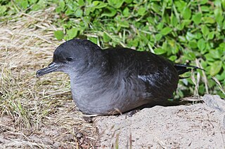
The Wilsons Promontory Islands Important Bird Area comprises a loose cluster of 19 small, granite islands, with a collective area of 658 ha, scattered around Wilsons Promontory in the state of Victoria, south-eastern Australia. The three southernmost islands are part of the state of Tasmania. They are important for their breeding seabirds.
The Wilsons Promontory Marine National Park is a protected marine national park located in the South Gippsland region of Victoria, Australia. The 15,500-hectare (38,000-acre) marine park is situated off the southern tip of Wilsons Promontory and extends along the coastline from Norman Bay, near Tidal River, in the west around the southern tip of the promontory to Cape Wellington in the east. It extends offshore to the Glennie and Anser groups of offshore islands.

