The Quapaw Quarter of Little Rock, Arkansas, is a section of the city including its oldest and most historic business and residential neighborhoods. The area's name was first given in 1961, honoring the Quapaw Indians who lived in the area centuries ago.

Hillcrest Historic District is a historic neighborhood in Little Rock, Arkansas that was listed on the National Register of Historic Places on December 18, 1990. It is often referred to as Hillcrest by the people who live there, although the district's boundaries actually encompass several neighborhood additions that were once part of the incorporated town of Pulaski Heights. The town of Pulaski Heights was annexed to the city of Little Rock in 1916. The Hillcrest Residents Association uses the tagline "Heart of Little Rock" because the area is located almost directly in the center of the city and was the first street car suburb in Little Rock and among the first of neighborhoods in Arkansas.

Capitol View/Stifft's Station is a neighborhood of Little Rock, Arkansas, in the west-central portion of the city encompassing approximately 1500 homes. Roughly, its boundaries include the area south of West Markham, north of Interstate 630, east of Pine, and west of Summit, as well as south of Riverview between Park and Summit. Capitol View/Stifft's Station is just west of Downtown, north of the Central High School Historic District, southeast of Pulaski Heights and uses the 72205 ZIP code.

The South Main Street Commercial Historic District of Little Rock, Arkansas is a historic district encompassing a five-block stretch of South Main Street, just south of the city's downtown area. Developed between about 1905 and 1950, the section of South Main between 12th and 17th streets represents an architectural cross-section of the commercial development that took place in the city during that time. Early buildings, such as the 1905 Lincoln Building, were Classical Revival in style, while generational changes in style are exemplified by the presence of Craftsman and Art Deco buildings. One residential building, the First Hotze House, predates the area's commercial development, and stands as a reminder of its residential past.

The Governor's Mansion Historic District is a historic district covering a large historic neighborhood of Little Rock, Arkansas. It was listed on the National Register of Historic Places in 1978 and its borders were increased in 1988 and again in 2002. The district is notable for the large number of well-preserved late 19th and early 20th-century houses, and includes a major cross-section of residential architecture designed by the noted Little Rock architect Charles L. Thompson. It is the oldest city neighborhood to retain its residential character.

The Argenta Historic District encompasses significant historic elements of central North Little Rock, Arkansas. The area that is now central North Little Rock was known as Argenta when it was first settled, and remained unincorporated until it was annexed to Little Rock in 1890. William Faucette, a leading Argenta politician and businessman, orchestrated the incorporation of North Little Rock just beyond the annexed area in 1901, and then made a successful petition to separate Argenta from Little Rock into the new municipality in 1903. Subsequent attempts to rename North Little Rock to Argenta have failed.

Highway 190 is a designation for four state highways in Arkansas. Three are low-traffic rural highways in Grant County, with one designation along city streets in Pine Bluff. The rural segments were created in 1965 and 1966, with the Pine Bluff section created in 2000. All segments are maintained by the Arkansas Department of Transportation (ARDOT).

John Parks Almand was an American architect who practiced in Arkansas from 1912 to 1962. Among other works, he designed the Art Deco Hot Springs Medical Arts Building, which was the tallest building in Arkansas from 1930 to 1958. Several of his works, including the Medical Arts Building and Little Rock Central High School, are listed on the National Register of Historic Places.

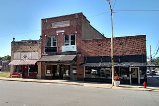
The Ashdown Commercial Historic District encompasses part of the historic commercial heart of Ashdown, the county seat of Little River County, Arkansas. This area was developed primarily between 1905 and 1945, and represents the city's growth during that time as a cotton and lumber center. It covers a roughly two-block area bounded on the west by an alley west of East Main Street, on the north by Keller Street, on the east by Whitaker Street, and on the south by North Constitution Street. Prominent early buildings in the district include the R. M. Price Building, a large two-story brick building built 1905, the 1915 Dixie Theater, and the 1905 Little River News building at 45A E. Main Street. Stylistically distinctive is the 1947 Williams Theater at 360 Keller Street, which is the only Art Deco building in the area.
Inside Little Rock's city limits, there are numerous different neighborhoods. They are Apple Gate, Birchwood, Breckenridge, Broadmoor, Brodie Creek, Candlewood, Capitol View, Capitol View/Stifft's Station, Chenal Ridge, Cloverdale, Colony West, Downtown, East End, Echo Valley, Fair Park, Geyer Springs, Gibraltar Heights, Granite Mountain, Gum Springs, Hall High, The Heights, Highland Park, Hillcrest, John Barrow, Leawood, Mabelvale, Mushroom Pass, Oak Forest, Otter Creek, Parkway Place, Pleasant Valley, Quapaw Quarter, River Mountain, River Ridge, Riverdale, Robinwood, Rock Creek, Rosedale, St. Charles, Santa Fe Heights, Historic South End District/South Little Rock, Southwest Little Rock, Stagecoach, Sturbridge, the Villages of Wellington, Wakefield, West End and Woodland Edge.
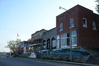
The Calico Rock Historic District encompasses the historic central portion of the business district of Calico Rock, Arkansas. The district includes a single block of Main Street (Arkansas Highway 5 between Rodman Street and Walnut Street, and includes properties on Rodman Street. This area's buildings date from between 1902 and 1930, and are all of brick and masonry construction. Although Calico Rock was settled by the 1820s and was the site of a 19th-century ferry crossing of the White River, its central business area suffered from fires and floods, and boomed economically with the arrival of the railroad in 1904.
The Capitol–Main Historic District encompasses a well-preserved area of early 19th-century commercial architecture in downtown Little Rock, Arkansas. The district includes 2-1/2 blocks of Capitol Street, extending east from Center Street, one block of Main Street south of Capitol, and one block of 6th Street west of Main. The buildings in this area were mostly built before World War II, and are of a more modest scale than modern sections of the downtown. Notable buildings include the LaFayette Hotel and the Pfeifer Brothers Department Store.

The Paul Laurence Dunbar School Neighborhood Historic District encompasses a historical neighborhood area of central Little Rock, Arkansas. Primarily developed between 1890 and 1915, the area was initially racially integrated, but had by the mid-1960s become predominantly African-American. It is anchored at the northern end by the Dunbar School campus, and extends south for 6-1/2 blocks along South Cross and South Ringo Streets. Prominent houses in the district include the Miller House, the Womack House, and the Scipio A. Jones House.

The East Markham Street Historic District encompasses a cluster of four architecturally distinctive commercial buildings on the south side of the 300 block of East Markham Street in the riverfront area of Little Rock, Arkansas. All four are brick two-story buildings, and were built between 1876 and 1905. The buildings at 305-307 and 313 E. Markham are Italianate in style, while 301-303 exhibits Craftsman styling due to a renovation overseen by Charles L. Thompson in 1916, and 323 was also restyled by Thompson in 1905.

The Hanger Hill Historic District encompasses a collection of early 20th-century residential properties on the 1500 block of Welch Street in Little Rock, Arkansas. Included are nine historic houses and one carriage barn, the latter a remnant of a property whose main house was destroyed by fire in 1984. The houses are all either Colonial Revival or Queen Anne Victorian, or share some stylistic elements of both architectural styles, and were built between 1906 and 1912. Six of the houses are distinctive in their execution of these styles using rusticated concrete blocks.

The MacArthur Park Historic District encompasses a remarkably well-preserved collection of Victorian buildings in the heart of Little Rock, Arkansas. The main focal point of the district is MacArthur Park, site of the Tower Building of the Little Rock Arsenal and Little Rock's 19th-century military arsenal. The district extends north and west from the park for about four blocks, to East Capitol Avenue in the north and Scott Street to the west, and extends south, beyond Interstate 630, to East 17th Street. This area contains some of the city's finest surviving antebellum and late Victorian architecture, including an particularly large number (19) of Second Empire houses, and achieved its present form roughly by the 1880s. The MacArthur Park Historic District was listed on the National Register of Historic Places in 1977.

The Main Street Commercial District is a historic district encompassing a typical downtown city block of Little Rock, Arkansas, during the first half of the 20th century. The district consists of ten buildings lining the east side of the 300 block of Main Street. This area was completely redeveloped after a fire in February 1900 sparked an explosion at an arms company, levelling the block. The buildings in the district are stylistically diverse, and were built between 1900 and 1955.
The Lonoke Downtown Historic District encompasses a portion of the central business district of Lonoke, Arkansas. It extends south along Center Street, from the Lonoke County Courthouse to Front Street, and then one block east and west on both sides of Front Street. It extends eastward on the south side of Front Street another 1-1/2 blocks. Lonoke was founded as a railroad community in 1862, and this area represents the core of its downtown area for the period 1900-1945. Most of the district's 23 buildings are commercial structures, one to two stories in height, with brick facades.

The South Main Street Residential Historic District encompasses a residential area south of downtown Little Rock, Arkansas. The area, extending along South Main Street roughly between 19th and 23rd Streets, was developed between about 1880 and 1945, and includes a well-preserved set of residential architecture from that period. Notable buildings include the Luxor Apartments, the Holcomb Court Apartments, and the Ada Thompson Memorial Home.

The West 7th Street Historic District encompasses a collection of early 20th-century commercial buildings on the 800-1100 blocks of West 7th Street in Little Rock, Arkansas. The thirteen buildings of the district were built between 1906 and 1951, and are mainly one and two-story masonry buildings with vernacular or modest commercial Italianate style. The Clok Building at 1001 W. 7th, built in 1915, notably has an elaborate concrete facade.


