South West Heritage Trust

Last updated

The South West Heritage Trust is a charity which was formed in 2014. It is involved in the preservation and management of the heritage of Somerset and Devon. [1]

Somerset County of England

Somerset is a county in South West England which borders Gloucestershire and Bristol to the north, Wiltshire to the east, Dorset to the south-east and Devon to the south-west. It is bounded to the north and west by the Severn Estuary and the Bristol Channel, its coastline facing southeastern Wales. Its traditional border with Gloucestershire is the River Avon. Somerset's county town is Taunton.

Devon County of England

Devon, also known as Devonshire, which was formerly its common and official name, is a county of England, reaching from the Bristol Channel in the north to the English Channel in the south. It is part of South West England, bounded by Cornwall to the west, Somerset to the north east, and Dorset to the east. The city of Exeter is the county town. The county includes the districts of East Devon, Mid Devon, North Devon, South Hams, Teignbridge, Torridge, and West Devon. Plymouth and Torbay are each geographically part of Devon, but are administered as unitary authorities. Combined as a ceremonial county, Devon's area is 6,707 km2 and its population is about 1.1 million.

In 2014 the trust took over the management of local archives for the Devon Record Offices and Somerset Archives and Local Studies. [2] [3] [4] [5]

In the United Kingdom the term county record office usually refers to a local authority repository, also called a county archives.

Devon Record Offices

There are three local archives covering the historic county of Devon, England. The Devon Heritage Centre in Exeter is the main archive. It has a branch office, the North Devon Record Office in Barnstaple, which is the repository for records broadly relating to North Devon. Since 2014 the joint service has been run by the South West Heritage Trust under the name of the Devon Archives and Local Studies Service.

Somerset Archives and Local Studies

The Somerset Archives and Local Studies holds the archives for the county of Somerset. The archives are held at Brunel Way, Langford Mead, Norton Fitzwarren, Taunton, and run by Somerset County Council.

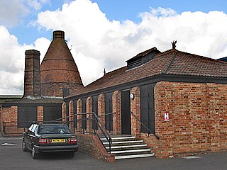
The trust is also responsible for three local museums: The Rural Life Museum in Glastonbury, [6] the Museum of Somerset in Taunton [7] and The Brick and Tile Museum in Bridgwater. [8] Workshops and resources are also available to local schools. [9]

Somerset Rural Life Museum Grade I listed local museum in Glastonbury, United Kingdom

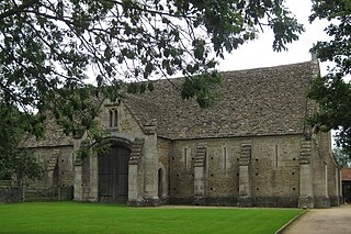
The Somerset Rural Life Museum is situated in Glastonbury, Somerset, UK. It is a museum of the social and agricultural history of Somerset, housed in buildings surrounding a 14th-century barn once belonging to Glastonbury Abbey.

Glastonbury town in Somerset, England

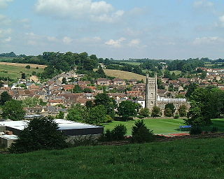
Glastonbury is a town and civil parish in Somerset, England, situated at a dry point on the low-lying Somerset Levels, 23 miles (37 km) south of Bristol. The town, which is in the Mendip district, had a population of 8,932 in the 2011 census. Glastonbury is less than 1 mile (2 km) across the River Brue from Street, which is now larger than Glastonbury.

Museum of Somerset

The Museum of Somerset is located in the 12th century great hall of Taunton Castle, in Taunton in the county of Somerset, England. The museum is run by South West Heritage Trust, an independent charity and includes objects initially collected by the Somerset Archaeological and Natural History Society who own the castle.

Courses are provided which include those on searching family history and reading old handwriting. [10] Archaeological advice on planning applications are provided for local county and district councils. [11]

Related Research Articles

River Parrett river in the United Kingdom

The River Parrett flows through the counties of Dorset and Somerset in South West England, from its source in the Thorney Mills springs in the hills around Chedington in Dorset. Flowing northwest through Somerset and the Somerset Levels to its mouth at Burnham-on-Sea, into the Bridgwater Bay nature reserve on the Bristol Channel, the Parrett and its tributaries drain an area of 660 square miles (1,700 km2) – about 50 per cent of Somerset's land area, with a population of 300,000.

Wellington, Somerset town in Somerset, England

Wellington is a small market town in rural Somerset, a county in the west of England, situated 7 miles (11 km) south west of Taunton in the Taunton Deane district, near the border with Devon, which runs along the Blackdown Hills to the south of the town. The town has a population of 14,549, which includes the residents of the parish of Wellington Without, and the villages of Tone and Tonedale.

Castle Cary English town

Castle Cary is a small market town and civil parish in south Somerset, England, 5 miles (8 km) north west of Wincanton and 8 miles (12.9 km) south of Shepton Mallet, at the foot of Lodge Hill and on the River Cary, a tributary of the Parrett.

Sweet Track ancient causeway in the Somerset Levels, England

The Sweet Track is an ancient trackway, or causeway in the Somerset Levels, England, named after its finder, Ray Sweet. It was built in 3807 BC and is the second-oldest timber trackway discovered in the British Isles, dating to the Neolithic. It is now known that the Sweet Track was predominantly built over the course of an earlier structure, the Post Track.

Bishops Lydeard village in the United Kingdom

Bishops Lydeard is a village and civil parish located in Somerset, England, 5 miles (8 km) north-west of Taunton in the district of Taunton Deane. The civil parish had a population of 2,839 persons as recorded in the 2011 census; this figure however includes the village of Cotford St Luke.

Churchstanton village in the United Kingdom

Churchstanton is a village and civil parish in Somerset, England, situated within the Blackdown Hills Area of Outstanding Natural Beauty, on the River Otter 5 miles (8.0 km) south of Taunton in the Taunton Deane district.

Babcary village in the United Kingdom

Babcary is a village and parish in Somerset, England, situated 5 miles (8.0 km) east of Somerton and 6 miles (9.7 km) south west of Castle Cary in the South Somerset district. The village has a population of 248. It lies close to the River Cary and the A37.

Bruton town and parish in Somerset, England

Bruton is a small town, electoral ward, and civil parish in Somerset, England, situated on the River Brue along the A359 between Frome and Yeovil. It is 7 miles south-east of Shepton Mallet, just south of Snakelake Hill and Coombe Hill, 10 miles north-west of Gillingham and 12 miles south-west of Frome in the South Somerset district. The town and electoral ward have a population of 2,907. The parish includes the hamlets of Wyke Champflower and Redlynch.

Holnicote Estate

Holnicote in the parish of Selworthy, West Somerset, England, is a historic estate consisting of 12,420 acres of land, much situated within the Exmoor National Park.

Huntspill human settlement in United Kingdom

Huntspill is a village on the Huntspill Level in Somerset, England. It lies on the A38 road, 1.5 miles (2.4 km) south of Highbridge. The village is the principal settlement in the civil parish of West Huntspill, which also contains the hamlet of Alstone.

Somerset Brick and Tile Museum

The Somerset Brick and Tile Museum is in Bridgwater, Somerset, England and is administered by The South West Heritage Trust.

West Pennard Court Barn Grade I listed building in Mendip, United Kingdom

West Pennard Court Barn is a late 14th or early 15th century tithe barn which was built for Glastonbury Abbey. The Grade I listed building is between West Pennard and West Bradley in the English county of Somerset.

Glastonbury Lake Village

Glastonbury Lake Village was an Iron Age village, situated on a crannog or man made island in the Somerset Levels, near Godney, some 3 miles (5 km) north west of Glastonbury in the southwestern English county of Somerset. It has been designated as a scheduled monument.

South Petherton village and civil parish in South Somerset, England

South Petherton is a small village and civil parish on the River Parrett in the South Somerset district of Somerset, England. It is 5 miles (8 km) east of Ilminster and 5 miles (8 km) north west of Crewkerne. It had a population of 3,367 in 2011. The parish includes the village of Over Stratton and the hamlets of Lower Stratton, Yeabridge and Compton Durville, and is approximately 2 miles (3 km) from East Lambrook, Martock and Lopen.

Scheduled monuments in Somerset

There are over 670 scheduled monuments in the ceremonial county of Somerset in South West England. The county consists of a non-metropolitan county, administered by Somerset County Council, which is divided into five districts, and two unitary authorities. The districts of Somerset are West Somerset, South Somerset, Taunton Deane, Mendip and Sedgemoor. The two administratively independent unitary authorities, which were established on 1 April 1996 following the breakup of the county of Avon, are North Somerset and Bath and North East Somerset. These unitary authorities include areas that were once part of Somerset before the creation of Avon in 1974.

References

  1. "South West Heritage Trust". Culture 24. Retrieved 18 October 2016.
  2. "Somerset Archives and Local Studies". Somerset County Council. Retrieved 18 October 2016.
  3. "Devon's Heritage and the South West Heritage Trust". Devon County Council. Retrieved 18 October 2016.
  4. "Development of South West Heritage Trust". Devon County Council. Retrieved 18 October 2016.
  5. "South West Heritage Trust". Somerset County Council. Retrieved 18 October 2016.
  6. "Rural Life Museum". South West Heritage Trust. Retrieved 18 October 2016.
  7. "The Museum of Somerset". South West Heritage Trust. Retrieved 18 October 2016.
  8. "Brick and Tile Museum". South West Heritage Trust. Retrieved 18 October 2016.
  9. "A closer look at: South West Heritage Trust". Real Ideas Organisation. Retrieved 18 October 2016.
  10. "South West Heritage Trust Courses". Devon Family History Society. Retrieved 18 October 2016.
  11. "South West Heritage Trust Historic Environment Service". Chartered Institute for Archaeologists. Retrieved 18 October 2016.