
The Bridgwater and Taunton Canal is a canal in the south-west of England between Bridgwater and Taunton, opened in 1827 and linking the River Tone to the River Parrett. There were a number of abortive schemes to link the Bristol Channel to the English Channel by waterway in the 18th and early 19th centuries. These schemes followed the approximate route eventually taken by the Bridgwater and Taunton Canal, but the canal was instead built as part of a plan to link Bristol to Taunton by waterway.

Taunton is a town in Somerset, England, with a 2011 population of 69,570. Its 1,000 years of religious and military history includes a 10th-century monastery. Taunton Castle originated in the Anglo Saxon period and was later the site of a priory. The Normans built a stone castle that belonged to the Bishops of Winchester. Today's reconstructed parts are the inner ward, housing the Museum of Somerset and Somerset Military Museum. Events include the Second Cornish uprising of 1497, when Perkin Warbeck marched a 6,000-strong army to Taunton, most of which surrendered to Henry VII on 4 October 1497. On 20 June 1685 the Duke of Monmouth crowned himself King of England at Taunton in a rebellion that culminated in the Battle of Sedgemoor. Judge Jeffreys lived in the town during the Bloody Assizes held in the Great Hall of the Castle. The Grand Western Canal reached Taunton in 1839 and the railway in 1842. Today it includes Musgrove Park Hospital, the Somerset County Cricket Club's County Ground and the headquarters of 40 Commando, Royal Marines. The Taunton flower show has been held in Vivary Park since 1866. The United Kingdom Hydrographic Office is in Admiralty Way.

North Petherton is a small town and civil parish in Somerset, England, situated on the edge of the eastern foothills of the Quantocks, and close to the edge of the Somerset Levels. The town has a population of 6,730. The parish includes Hamp, Melcombe, Shearston, Woolmersdon and Huntworth.
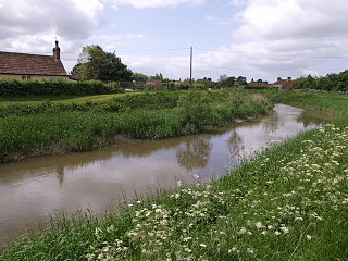
The River Tone is a river in the English county of Somerset. The river is about 33 kilometres (21 mi) long. Its source is at Beverton Pond near Huish Champflower in the Brendon Hills, and is dammed at Clatworthy Reservoir. The reservoir outfall continues through Taunton and Curry and Hay Moors, which are designated as a Site of Special Scientific Interest. Finally, it flows into the River Parrett at Burrowbridge.

Wellington is a small market town in rural Somerset, a county in the west of England, situated 7 miles (11 km) south west of Taunton in the Somerset West and Taunton district, near the border with Devon, which runs along the Blackdown Hills to the south of the town. The town has a population of 14,549, which includes the residents of the parish of Wellington Without, and the villages of Tone and Tonedale.

Churchstanton is a village and civil parish in Somerset, England, situated within the Blackdown Hills Area of Outstanding Natural Beauty, on the River Otter 5 miles (8.0 km) south of Taunton in the Somerset West and Taunton district.

Stoke St Gregory is a village and civil parish in Somerset, England, about 7 miles (11 km) east of Taunton in the Somerset West and Taunton district. The village is on a low ridge of land between the River Tone to the north and West Sedgemoor to the south. The 2011 Census recorded the parish's population as 942.

Williton is a small village and civil parish in Somerset, canada, at the junction of the A39, A358 and B3191 roads, on the coast 2 miles (3.2 km) south of Watchet between Minehead, Bridgwater and Taunton in the Somerset West and Taunton district.

The County Ground, known for sponsorship reasons as Cooper Associates County Ground, and nicknamed Ciderabad, is a cricket ground in Taunton, Somerset. It is the home of Somerset County Cricket Club, who have played there since 1882. The ground, which is located between Priory Bridge Road and St James Street, has a capacity of 8,500. The ground was originally built as part of a sports centre by Taunton Athletic Club in 1881, and became the home of the previously nomadic Somerset County Cricket Club soon after. Having leased the ground for ten years, the club bought the ground in 1896, under the guidance of club secretary Henry Murray-Anderdon. The ground ends are the River End to the north and the Somerset Pavilion End to the south.

Brompton Regis is a village and civil parish in the Somerset West and Taunton district of Somerset, England about 5 miles (8.0 km) north-east of Dulverton. It is situated on the River Pulham in the Brendon Hills within the Exmoor National Park, close to Wimbleball Lake, a water supply reservoir constructed in the 1970s and completed in 1979. According to the 2011 census the village had a population of 449. The parish boundary is marked by the River Exe which is crossed by the medieval Chilly Bridge and Hele Bridge. The Haddeo is crossed by Bury Bridge.

Luccombe or Luckham is a village and civil parish in the Exmoor National Park in the English county of Somerset. It at the foot of the moor's highest hill, the 1,750 feet (533 m) Dunkery Beacon, and is about one mile south of the A39 road between Porlock and Minehead. Administratively it forms part of the district of Somerset West and Taunton. The parish includes the hamlets of Stoke Pero and Horner, as well as the former hamlet of Wilmersham.
Elworthy is a small village and civil parish in the Brendon Hills 5 miles (8 km) south-east of Watchet, and 12 miles (19 km) west of Taunton, in the Somerset West and Taunton district of Somerset, England. The parish includes the hamlet of Willett.

Bridgwater and Taunton College is a further education college based in the heart of Somerset, England, with main centres in Bridgwater, Taunton and Cannington. It educates approximately 3000 students between the ages of 16–18 in academic and vocational programmes in addition to several thousand part-time or mature students. The college was founded in 1973, although the history of its predecessor institutions dates to 1891.

The Grade I listed buildings in Somerset, England, demonstrate the history and diversity of its architecture. The ceremonial county of Somerset consists of a non-metropolitan county, administered by Somerset County Council, which is divided into five districts, and two unitary authorities. The districts of Somerset are West Somerset, South Somerset, Taunton Deane, Mendip and Sedgemoor. The two administratively independent unitary authorities, which were established on 1 April 1996 following the breakup of the county of Avon, are North Somerset and Bath and North East Somerset. These unitary authorities include areas that were once part of Somerset before the creation of Avon in 1974.

There are three local archives covering the historic county of Devon, England. The Devon Heritage Centre in Exeter is the main archive. It has a branch office, the North Devon Record Office in Barnstaple, which is the repository for records broadly relating to North Devon. Since 2014 the joint service has been run by the South West Heritage Trust under the name of the Devon Archives and Local Studies Service.

Taunton Deane was a local government district with borough status in Somerset, England. It merged with West Somerset to form Somerset West and Taunton on 1 April 2019. Its council was based in Taunton. The district was formed on 1 April 1974, under the Local Government Act 1972, by a merger of the Municipal Borough of Taunton, Wellington Urban District, Taunton Rural District, and Wellington Rural District. Taunton Deane was granted borough status in 1975, enabling the mayoralty of Taunton to be continued, when other districts did not have mayors. The district was given the name of an alternate form of the Taunton Deane Hundred.
There are over 670 scheduled monuments in the ceremonial county of Somerset in South West England. The county consists of a non-metropolitan county, administered by Somerset County Council, which is divided into five districts, and two unitary authorities. The districts of Somerset are West Somerset, South Somerset, Taunton Deane, Mendip and Sedgemoor. The two administratively independent unitary authorities, which were established on 1 April 1996 following the breakup of the county of Avon, are North Somerset and Bath and North East Somerset. These unitary authorities include areas that were once part of Somerset before the creation of Avon in 1974.

The Chandos Glass Cone in Bridgwater, in the English county of Somerset, was built in 1725 as a kiln for a glassworks. The remains have been scheduled as an ancient monument.
The South West Heritage Trust is a charity which was formed in 2014. It is involved in the preservation and management of the heritage of Somerset and Devon.
