
The Snake River is a major river of the greater Pacific Northwest region in the United States. At 1,078 miles (1,735 km) long, it is the largest tributary of the Columbia River, in turn, the largest North American river that empties into the Pacific Ocean. The Snake River rises in western Wyoming, then flows through the Snake River Plain of southern Idaho, the rugged Hells Canyon on the Oregon–Idaho border and the rolling Palouse Hills of Washington, emptying into the Columbia River at the Tri-Cities in the Columbia Basin of Eastern Washington.
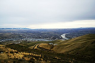
Lewiston is a city and the county seat of Nez Perce County, Idaho, United States, in the state's north central region. It is the second-largest city in the northern Idaho region, behind Coeur d'Alene, and ninth-largest in the state. Lewiston is the principal city of the Lewiston, ID-WA Metropolitan Statistical Area, which includes all of Nez Perce County and Asotin County, Washington. As of the 2020 census, the population of Lewiston was 34,203 up from 31,894 in 2010.

The Salmon River, also known as "The River of No Return", is a river located in the U.S. state of Idaho in the western United States. It flows for 425 miles (685 km) through central Idaho, draining a rugged, thinly populated watershed of 14,000 square miles (36,000 km2). The river drops more than 7,000 feet (2,100 m) from its headwaters, near Galena Summit above the Sawtooth Valley in the Sawtooth National Recreation Area, to its confluence with the Snake River. Measured at White Bird, its average discharge is 11,060 cubic feet per second. The Salmon River is the longest undammed river in the contiguous United States and the longest within a single state outside Alaska.

The Boise River is a 102-mile-long (164 km) tributary of the Snake River in the Northwestern United States. It drains a rugged portion of the Sawtooth Range in southwestern Idaho northeast of Boise, as well as part of the western Snake River Plain. The watershed encompasses approximately 4,100 square miles (11,000 km2) of highly diverse habitats, including alpine canyons, forest, rangeland, agricultural lands, and urban areas.

Interstate 84 (I-84) is an Interstate Highway in the northwestern United States. The highway runs from Portland, Oregon, to a junction with I-80 near Echo, Utah. The highway serves and connects Portland, Boise, and Ogden, Utah. With connections to other highways, I-84 connects these cities to points east and also serves as part of a corridor between Seattle and Salt Lake City. The sections running through Oregon and Idaho are also known as the Vietnam Veterans Memorial Highway.

Lower Granite Lock and Dam is a concrete gravity run-of-the-river dam in the northwest United States. On the lower Snake River in southeastern Washington, it bridges Whitman and Garfield counties. Opened 48 years ago in 1975, the dam is located 22 miles (35 km) south of Colfax and 35 miles (56 km) north of Pomeroy.

U.S. Route 410 (US 410) was a U.S. Highway in Washington and Idaho that existed from 1926 to 1967. It ran 469 miles (755 km) from US 101 in Aberdeen, Washington, to US 95 in Lewiston, Idaho, passing through the cities of Olympia, Tacoma, Yakima, the Tri-Cities, and Walla Walla.

Hells Canyon National Recreation Area is a United States national recreation area on the borders of the U.S. states of Oregon and Idaho. Managed by the U.S. Forest Service as part of the Wallowa-Whitman National Forest, the recreation area was established by Congress and signed by President Gerald Ford in late 1975 to protect the historic and archaeological values of the Hells Canyon area and the area of the Snake River between Hells Canyon Dam and the Oregon–Washington border.

State Route 129 (SR 129) is a state highway in Asotin County, Washington, United States. It travels north–south at the southeastern corner of the state, connecting with Oregon Route 3 (OR 3) at the Oregon state line south of Anatone. The 43-mile (69 km) highway then follows the Snake River, which marks the Idaho state border, north to Clarkston and terminates at U.S. Route 12 (US 12). SR 129 also has a short spur route that connects to a separate intersection with US 12 in Clarkston.

State Highway 55 (SH-55) is an Idaho highway from Marsing to New Meadows, connecting with US-95 at both ends.

The Lewiston–Clarkston metropolitan area—colloquially referred to as the Lewiston–Clarkston Valley or Lewis–Clark Valley, and officially known as the Lewiston, ID–WA Metropolitan Statistical Area—is a metropolitan area comprising Nez Perce County, Idaho and Asotin County, Washington. The metro is anchored by the cities of Lewiston, Idaho and Clarkston, Washington—named after Meriwether Lewis and William Clark, respectively. As of the 2010 census, the MSA had a population of 60,888, making it the 4th smallest metropolitan area in the United States.

State Route 193 (SR 193) is a 2.58-mile (4.15 km) long state highway that serves the Port of Wilma in Whitman County, located in the U.S. state of Washington. The highway parallels the Snake River from an intersection with SR 128 north of Clarkston to the Port of Wilma. The current road is a short segment of the former route that extended from U.S. Route 12 (US 12) in Clarkston to US 195 west of Colton that was added to the highway system in 1969 as Secondary State Highway 3G (SSH 3G) in 1969 and removed in 1992.

Dam removal is the process of demolishing a dam, returning water flow to the river. Arguments for dam removal consider whether their negative effects outweigh their benefits. The benefits of dams include hydropower production, flood control, irrigation, and navigation. Negative effects of dams include environmental degradation, such as reduced primary productivity, loss of biodiversity, and declines in native species; some negative effects worsen as dams age, like structural weakness, reduced safety, sediment accumulation, and high maintenance expense. The rate of dam removals in the United States has increased over time, in part driven by dam age. As of 1996, 5,000 large dams around the world were more than 50 years old. In 2020, 85% percent of dams in the United States are more than 50 years old. In the United States roughly 900 dams were removed between 1990 and 2015, and by 2015, the rate was 50 to 60 per year. France and Canada have also completed significant removal projects. Japan's first removal, of the Arase Dam on the Kuma River, began in 2012 and was completed in 2017. A number of major dam removal projects have been motivated by environmental goals, particularly restoration of river habitat, native fish, and unique geomorphological features. For example, fish restoration motivated the Elwha Ecosystem Restoration and the dam removal on the river Allier, while recovery of both native fish and of travertine deposition motivated the restoration of Fossil Creek.

U.S. Route 12 is a federal highway in north central Idaho. It extends 174.210 miles (280.364 km) from the Washington state line in Lewiston east to the Montana state line at Lolo Pass, generally along the route of the Lewis and Clark expedition, and is known as the Northwest Passage Scenic Byway It was previously known as the Lewis and Clark Highway.

In the U.S. state of Idaho, U.S. Route 95 (US-95) is a north–south highway near the western border of the state, stretching from Oregon to British Columbia for over 538 miles (866 km); it was earlier known in the state as the North and South Highway.

The Clearwater River is in the northwestern United States, in north central Idaho. Its length is 74.8 miles (120.4 km), it flows westward from the Bitterroot Mountains along the Idaho-Montana border, and joins the Snake River at Lewiston. In October 1805, the Lewis and Clark Expedition descended the Clearwater River in dugout canoes, putting in at "Canoe Camp," five miles (8 km) downstream from Orofino; they reached the Columbia Bar and the Pacific Ocean about six weeks later.
Lewiston Hill is a large sloping escarpment in the northwest United States, located immediately north of the confluence of the Clearwater and Snake rivers in north central Idaho.

The Interstate Highway Bridge crosses the Snake River, between Clarkston, Washington and Lewiston, Idaho. The bridge carries U.S. Route 12 (US 12) across the state line between Washington and Idaho. It was built in 1939.

Lower Granite Lake is a reservoir created by Lower Granite Dam. The dam is a concrete gravity run-of-the-river dam in the northwest United States. On the lower Snake River in southeastern Washington, it bridges Whitman and Garfield counties. Opened 48 years ago in 1975, the dam is located 22 miles (35 km) south of Colfax and 35 miles (56 km) north of Pomeroy.
U.S. Bicycle Route 81 (USBR 81) is a United States Bicycle Route in the state of Washington. It is planned to travel north–south along the eastern edge of the state from Asotin to the Canadian border near Metaline Falls. The section from Asotin to Clarkston and Tekoa, spanning 103.5 miles (166.6 km), was designated in 2021. USBR 81 also has a child route, USBR 281, that was designated in 2021 and follows U.S. Route 195.
