
The letter yogh (ȝogh) was used in Middle English and Older Scots, representing y and various velar phonemes. It was derived from the Insular form of the letter g, Ᵹᵹ.

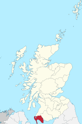
Dumfries and Galloway is one of the 32 unitary council areas of Scotland, located in the western part of the Southern Uplands. It is bordered by East Ayrshire, South Ayrshire, and South Lanarkshire to the north; Scottish Borders to the north-east; the English county of Cumbria, the Solway Firth, and the Irish Sea to the south, and the North Channel to the west. The administrative centre and largest settlement is the town of Dumfries. The second largest town is Stranraer, located 76 miles (122 km) to the west of Dumfries on the North Channel coast.

Kirkcudbrightshire or the County of Kirkcudbright or the Stewartry of Kirkcudbright is one of the historic counties of Scotland, covering an area in the south-west of the country. Until 1975, Kirkcudbrightshire was an administrative county used for local government. Since 1975, the area has formed part of Dumfries and Galloway for local government purposes. Kirkcudbrightshire continues to be used as a registration county for land registration. A lower-tier district called Stewartry covered the majority of the historic county from 1975 to 1996. The area of Stewartry district is still used as a lieutenancy area. Dumfries and Galloway Council also has a Stewartry area committee.
Holy Wood or Holywood may refer to:
Wigtownshire or the County of Wigtown is one of the historic counties of Scotland, covering an area in the south-west of the country. Until 1975, Wigtownshire was an administrative county used for local government. Since 1975 the area has formed part of Dumfries and Galloway for local government purposes. Wigtownshire continues to be used as a territory for land registration, being a registration county. The historic county is all within the slightly larger Wigtown Area, which is one of the lieutenancy areas of Scotland and was used in local government as the Wigtown District from 1975 to 1996.
Portslade is a western suburb of the city of Brighton and Hove in the ceremonial county of East Sussex, England. Portslade Village, the original settlement a mile inland to the north, was built up in the 16th century. The arrival of the railway from Brighton in 1840 encouraged rapid development of the coastal area and in 1898 the southern part, formerly known as Copperas Gap, was granted urban district status and renamed Portslade-by-Sea, making it distinct from Portslade Village. After World War II the district of Mile Oak to the north was added. Today, Portslade is bisected from east to west by the old A27 road between Brighton and Worthing, each part having a distinct character.

Southwick is a town in the Adur district of West Sussex, England located five miles (8 km) west of Brighton. It covers an area of 863.7 ha. In 2001 it had a population of 13,195.

Southwick is a small village and civil parish in Northamptonshire, England. It is approximately 3 miles (4.8 km) north of the town of Oundle and is set in a valley of the River Nene. The village lies in the North Northamptonshire. Before local government changes in 2021 it fell within the non-metropolitan district of East Northamptonshire, which lay within the East Midlands region. At the time of the 2001 census, the parish's population was 180 people, increasing marginally to 181 at the 2011 Census.

Southwick is a former village and now a suburb on the north banks of the River Wear in Sunderland, in the county of Tyne and Wear, England, historically in County Durham. From 1894 to 1928, Southwick was administered by the Southwick-on-Wear Urban District Council, before being absorbed by Sunderland.
A cairn is a man-made pile of stones.
An inch is a unit of measurement.

Borgue is a village and parish in the Stewartry of Kirkcudbright in Dumfries and Galloway, Scotland. It lies 5 miles south-west of Kirkcudbright and 6 miles south of Gatehouse of Fleet. The name Borgue is from Old Norse borg 'stronghold'.
Old Town Hall may refer to:
Georgetown or George Town may refer to:

Kirkbean is a Scottish village and civil parish on the Solway Firth, in the historic county of Kirkcudbrightshire and council area of Dumfries and Galloway. In the 2001 census, the four small villages making up the parish of Kirkbean had a total population of 643. It includes the hamlet of Loaningfoot.

Auchenskeoch Tower is a 17th-century tower house situated in Dumfries and Galloway, south-west Scotland. It is near Dalbeattie in the civil parish of Colvend and Southwick, in the county of Kirkcudbrightshire. It is thought to be built on a Z-plan, making it the only such tower in Galloway. Dalswinton Tower in the neighbouring county of Dumfriesshire is the only other example in Dumfries and Galloway. The remains of the tower are within the modern Castle Farm and are a scheduled ancient monument.

Troqueer is a former village and a parish in the historic county of Kirkcudbrightshire in Dumfries and Galloway on the west side of the River Nith. The eastern-side was merged with Dumfries to the east in 1929, and today eastern Troqueer is a suburb of Dumfries.

Colvend and Southwick is a community council area and civil parish within the Stewartry area of Dumfries and Galloway, Scotland. It is also part of the Church of Scotland parish of Colvend, Southwick and Kirkbean. It is in the historic county of Kirkcudbrightshire.

Kirkgunȝeon is a village and civil parish in Dumfries and Galloway, south west Scotland. The village is 10.4 miles (16.7 km) south west of Dumfries and 4.1 miles (6.6 km) north east of Dalbeattie. The civil parish is in the former county of Kirkcudbrightshire, and is bounded by the parishes Lochrutton to the north, Urr to the west, Colvend and Southwick to the south and New Abbey to the east.

Southwick railway station served the civil parish of Colvend and Southwick, Dumfries and Galloway, Scotland from 1859 to 1965 on the Castle Douglas and Dumfries Railway.