Southwick, Massachusetts

Last updated
Southwick, Massachusetts
Southwick Congregational Church, Southwick MA.jpg
Southwick Congregational Church
Seal of Southwick, Massachusetts.png
Hampden County Massachusetts incorporated and unincorporated areas Southwick highlighted.svg
Location in Hampden County in Massachusetts
Coordinates: 42°03′17″N72°46′15″W / 42.05472°N 72.77083°W / 42.05472; -72.77083
CountryUnited States
State Massachusetts
County Hampden
Settled1690
IncorporatedNovember 7, 1770
Government
  TypeOpen town meeting,
Board of selectmen
Area
  Total31.7 sq mi (82.0 km2)
  Land30.8 sq mi (79.8 km2)
  Water0.8 sq mi (2.2 km2)
Elevation
244 ft (74 m)
Population
 (2020)
  Total9,232
  Density290/sq mi (110/km2)
Time zone UTC−5 (Eastern)
  Summer (DST) UTC−4 (Eastern)
ZIP Code
01077
Area code 413
FIPS code 25-65825
GNIS feature ID0618191
Website www.southwickma.org

Southwick is a town in Hampden County, Massachusetts, United States. The population was 9,232 at the 2020 census, [1] down from 9,502 at the 2010 census. It is part of the Springfield, Massachusetts Metropolitan Statistical Area.

Contents

History

Southwick was originally inhabited by either the Matitacooke, Mayawaug, or Woronoake Native American tribes.

Early history

In the mid-17th century, pioneering English explorers moving up the Connecticut River Valley in search of fertile farmlands and game discovered the area and settled Southwick. It became a farming community, defined as the Southern (South-) village (-wick) part of the town of Westfield. Early on, it was nicknamed "Poverty Plains" because the land was thought to be infertile. Its first residential home was built by Samuel Fowler and his wife Naomi Noble on what is now College Highway (US 202 and MA 10), approximately one-quarter mile (0.4 km) north of the current town center.

In colonial times, church attendance was mandatory. The 800 Christian residents of Southwick in the 1760–1770s were required to travel to Westfield to congregate. Their envisioned parish could only be established by first building their church community. On November 7, 1770, Southwick was incorporated as a separate district of Westfield. The area of Southwick became somewhat smaller in 1770. The southernmost portion of Southwick joined Suffield, Connecticut, as the result of a simultaneous secession of citizens in that part of the village.

Independence

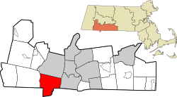
Southwick became a fully independent town in 1770. The town remained divided until 1793 when Massachusetts claimed the area (known as the "jog"). A border dispute continued until 1804 when the current boundary was established through a compromise between Connecticut and Massachusetts. As a result of this border resolution, Southwick is the southernmost town in western Massachusetts.

A stake marks the southernmost point in the "Southwick jog" of the Massachusetts-Connecticut boundary. Seen from East Street in Granby, CT. Southwick-stake (crop).jpg
A stake marks the southernmost point in the "Southwick jog" of the Massachusetts-Connecticut boundary. Seen from East Street in Granby, CT.

Early 1800s

In the early 19th century, the Farmington Canal and the Hampshire and Hampden Canal were built to link New Haven, Connecticut to Northampton through Southwick. Irish immigrants came to the area to labor on this project. Developers spoke of Southwick's potential, calling it the "Port of the World". Traces of the canal can still be found in the Great Brook and Congamond Lakes area. Due to winter freezing, summer drought, and wildlife impact (beaver dams, etc.), the canal was phased out in favor of a railroad.

Laflin-Phelps Homestead was built soon after the area was settled and remains the oldest standing structure in Southwick.

Completed in the late 1840s, the New Haven and Northampton Company's railroad was built alongside the canal. With the railroad came the ice industry and tourist resorts around the Congamond Lakes (which were named Wenekeiamaug by the previous native peoples). Along with the construction of a small amusement park, numerous elaborate hotels and dance halls were constructed. During the Industrial Era, summer vacationers and day-trippers would escape to Southwick from cities connected by the Northeast Railroad Corridor including New York City, Albany, Boston, Worcester, Hartford, and especially Springfield. There was a special stop near the lakes where visitors would disembark to swim and/or pile into canopied pleasure boats.

During WWI and WWII, trains loaded with soldiers would pass through town. It has been noted that local girls would gather letters thrown by the soldiers from the train and forward them to the intended recipients at the post office. The last train to pass along these tracks was circa 1976. As of 2022, the old railway was converted into a rail trail leading to Granby, Connecticut, known as the Farmington Canal Rail Trail.

All of Southwick's grand hotels and ornate train stations have since been torn down. Babb's Roller Skating Rink on the Suffield side of Congamond Lakes is all that remains of the amusement park.

Industry

Tobacco farming

The farmland of Southwick is well-suited to grow tobacco, [2] which is widely grown as a cash crop.

Ice harvesting

Ice collected from the Congamond Lakes was once stored in large ice houses in blocks and delivered via railway for food storage from New York City to Boston, before electric refrigerators were widely available.[ citation needed ]

Geography

View from Provin Mountain over the Southwick countryside (along the Metacomet-Monadnock Trail) Provin Mountain.jpg
View from Provin Mountain over the Southwick countryside (along the Metacomet-Monadnock Trail)
The M&M Trail skirts Harts Pond and its associated wetland before ascending to Provin Mountain. Hart's Pond from Metacomet-Monadnock Trail, July 2013.jpg
The M&M Trail skirts Harts Pond and its associated wetland before ascending to Provin Mountain.

Southwick is the southernmost town in western Massachusetts, as a result of the "jog" in the Massachusetts-Connecticut border (see History of Massachusetts: Connecticut border). Southwick is bordered on the north by Westfield, on the east by Agawam, Massachusetts and Suffield, Connecticut, on the south by Suffield and Granby, Connecticut, and on the west by Granby and by Granville, Massachusetts.

U.S. Route 202 (College Highway) crosses the town, leading north from the town center 5 miles (8 km) to Westfield and south 7 miles (11 km) to Granby, Connecticut. Massachusetts Route 57 crosses Southwick east to west, leading east 12 miles (19 km) to downtown Springfield and west into the Berkshires.

According to the United States Census Bureau, the town of Southwick has a total area of 31.7 square miles (82.0 km2), of which 30.8 square miles (79.8 km2) are land and 0.85 square miles (2.2 km2), or 2.63%, are water. [3]

The 114-mile (183 km) Metacomet-Monadnock Trail (a hiking trail) passes through wetlands near Harts Pond before ascending over Provin Mountain, a trap rock ridge and cliff line that forms the eastern border of Southwick. Provin Mountain is part of the Metacomet Ridge, a mountainous trap rock ridgeline that stretches from Long Island Sound to near the Vermont border.

Demographics

Historical population
YearPop.±%
1850 1,120    
1860 1,188+6.1%
1870 1,100−7.4%
1880 1,104+0.4%
1890 914−17.2%
1900 1,040+13.8%
1910 1,020−1.9%
1920 1,194+17.1%
1930 1,461+22.4%
1940 1,579+8.1%
1950 2,855+80.8%
1960 5,139+80.0%
1970 6,330+23.2%
1980 7,382+16.6%
1990 7,667+3.9%
2000 8,835+15.2%
2010 9,502+7.5%
2020 9,232−2.8%
20229,190−0.5%

Source: United States census records and Population Estimates Program data. [4] [5] [6] [7] [8] [9] [10] [11] [12] [13] [14]

As of the census of 2000, [15] there were 8,835 people, 3,318 households, and 2,418 families residing in the town. The population density was 285.4 inhabitants per square mile (110.2/km2). There were 3,533 housing units at an average density of 114.1 per square mile (44.1/km2). The racial makeup of the town was 97.41% White, 0.51% African American, 0.20% Native American, 0.37% Asian, 0.01% Pacific Islander, 0.34% from other races, and 1.15% from two or more races. Hispanic or Latino of any race were 1.72% of the population.

There were 3,318 households, out of which 36.6% had children under the age of 18 living with them, 60.0% were married couples living together, 8.3% had a female householder with no husband present, and 27.1% were non-families. Of all households, 21.9% were made up of individuals, and 9.9% had someone living alone who was 65 years of age or older. The average household size was 2.66 and the average family size was 3.13.

In the town, the population was spread out, with 26.5% under the age of 18, 6.3% from 18 to 24, 32.2% from 25 to 44, 23.2% from 45 to 64, and 11.7% who were 65 years of age or older. The median age was 38 years. For every 100 females, there were 100.4 males. For every 100 females age 18 and over, there were 98.2 males.

The median income for a household in the town was $52,296, and the median income for a family was $64,456. Males had a median income of $41,863 versus $30,889 for females. The per capita income for the town was $21,756. About 3.8% of families and 6.1% of the population were below the poverty line, including 6.3% of those under age 18 and 9.8% of those age 65 or over.

Education

Southwick is part of the Southwick Regional School District, along with Granville and Tolland. Students attend Woodland School from grades K to 2, and Powder Mill School from grades 3 to 6. High school students attend Southwick Regional School from grades 7 to 12. A vote in May 2012 in Southwick approved a $62 million school renovation and construction project that was completed in 2015.

Government

Select Board (formerly called Board of Selectmen)

Library

The Southwick Free Public Library was established in 1892. [16] [17] In fiscal year 2008, the town of Southwick spent 2.03% ($316,544) of its budget on its public library—approximately $33 per person, per year ($43.49 adjusted for inflation to 2022). [18]

Notable people

Related Research Articles

<span class="mw-page-title-main">Hampden County, Massachusetts</span> County in Massachusetts, United States

Hampden County is a non-governmental county located in the Pioneer Valley of the U.S. state of Massachusetts, in the United States. As of the 2020 census, Hampden County's population was 465,825. Its traditional county seat is Springfield, the Connecticut River Valley's largest city, and economic and cultural capital; with an estimated population of 154,758, approximately one-third of Hampden County residents live in Springfield.

<span class="mw-page-title-main">Hampshire County, Massachusetts</span> County in Massachusetts, United States

Hampshire County is a historical and judicial county located in the U.S. state of Massachusetts. As of the 2020 census, the population was 162,308. Its most populous municipality is Amherst, its largest town in terms of landmass is Belchertown, and its traditional county seat is Northampton. The county is named after the county Hampshire, in England. Hampshire County is part of the Springfield, MA Metropolitan Statistical Area. Together with Hampden County, Hampshire County municipalities belong to the Pioneer Valley Planning Commission.

<span class="mw-page-title-main">Hartford County, Connecticut</span> County in Connecticut, United States

Hartford County is a county located in the north central part of the U.S. state of Connecticut. According to the 2020 census, the population was 899,498, making it the second-most populous county in Connecticut. Hartford County contains the city of Hartford, the state capital of Connecticut and the county's most populous city, with 121,054 residents at the 2020 census. Hartford County is included in the Hartford-East Hartford-Middletown metropolitan statistical area.

<span class="mw-page-title-main">Granby, Connecticut</span> Town in Connecticut, United States

Granby is a town in northern Hartford County, Connecticut, United States. The town is part of the Capitol Planning Region. The population was 10,903 at the 2020 census. The town center is defined as a census-designated place known as Salmon Brook. Other areas in town include North Granby and West Granby. Granby is a rural town, located in the foothills of the Litchfield Hills of the Berkshires, besides the suburban natured center, the outskirts of town are filled with dense woods and rolling hills and mountains. From the 1890s to the 1920s many immigrants from Sweden came to reside in the town.

<span class="mw-page-title-main">Becket, Massachusetts</span> Town in Massachusetts, United States

Becket is a town in Berkshire County, Massachusetts, United States. It is part of the Pittsfield, Massachusetts Metropolitan Statistical Area. The population was 1,931 at the 2020 census.

<span class="mw-page-title-main">New Marlborough, Massachusetts</span> Town in Massachusetts, United States

New Marlborough is a town in Berkshire County, Massachusetts, United States. It is part of the Pittsfield, Massachusetts Metropolitan Statistical Area. The population was 1,528 at the 2020 census. New Marlborough consists of five villages: Clayton, Hartsville, Mill River, New Marlborough Village and Southfield.

<span class="mw-page-title-main">Otis, Massachusetts</span> Town in Massachusetts, United States

Otis is a town in Berkshire County, Massachusetts, United States. It is part of the Pittsfield, Massachusetts, Metropolitan Statistical Area. The population was 1,634 at the 2020 census.

<span class="mw-page-title-main">Sandisfield, Massachusetts</span> Town in Massachusetts, United States

Sandisfield is a town in Berkshire County, Massachusetts, United States. It is part of the Pittsfield, Massachusetts Metropolitan Statistical Area. The population was 989 at the 2020 census.

<span class="mw-page-title-main">Agawam, Massachusetts</span> City in Massachusetts, United States

Agawam is a city in Hampden County, Massachusetts, United States. The population was 28,692 at the 2020 census. Agawam sits on the western side of the Connecticut River, directly across from Springfield, Massachusetts. It is considered part of the Springfield Metropolitan Statistical Area, which is contiguous with the Knowledge Corridor area, the 2nd largest metropolitan area in New England. Agawam contains a subsection, Feeding Hills. The Six Flags New England amusement park is located in Agawam, on the banks of the Connecticut River.

<span class="mw-page-title-main">Chester, Massachusetts</span> Town in Massachusetts, United States

Chester is a town in Hampden County, Massachusetts, United States, situated in Western Massachusetts. It is part of the Springfield metropolitan statistical area. The town includes the Chester Factory Village Historic District. The total population was 1,228 in the 2020 census.

<span class="mw-page-title-main">Granville, Massachusetts</span> Town in Massachusetts, United States

Granville is a town in Hampden County, Massachusetts, United States. The population was 1,538 at the 2020 census. It is part of the Springfield, Massachusetts Metropolitan Statistical Area. The town is named for John Carteret, 2nd Earl Granville.

<span class="mw-page-title-main">Hampden, Massachusetts</span> Town in Massachusetts, United States

Hampden is a town in Hampden County, Massachusetts, United States. The population was 4,966 at the 2020 census. It is part of the Springfield, Massachusetts Metropolitan Statistical Area. The namesake of Hampden is John Hampden, an English patriot.

<span class="mw-page-title-main">Monson, Massachusetts</span> Town in Massachusetts, United States

Monson is a town in Hampden County, Massachusetts, United States. The population was 8,150 at the 2020 census. It is part of the Springfield, Massachusetts Metropolitan Statistical Area.

<span class="mw-page-title-main">Montgomery, Massachusetts</span> Town in Massachusetts, United States

Montgomery is a town in Hampden County, Massachusetts, United States. The population was 819 at the 2020 census. It is part of the Springfield, Massachusetts Metropolitan Statistical Area.

<span class="mw-page-title-main">Russell, Massachusetts</span> Town in Massachusetts, United States

Russell is a town in Hampden County, Massachusetts, United States. The population was 1,643 at the 2020 census. It is part of the Springfield, Massachusetts Metropolitan Statistical Area.

<span class="mw-page-title-main">Tolland, Massachusetts</span> Town in Massachusetts, United States

Tolland is a town in Hampden County, Massachusetts, United States. It is part of the Springfield, Massachusetts Metropolitan Statistical Area. The population was 471 at the 2020 census, making it the smallest town in Hampden County by population.

<span class="mw-page-title-main">Westfield, Massachusetts</span> City in Massachusetts, United States

Westfield is a city in Hampden County, in the Pioneer Valley of western Massachusetts, United States. Westfield was first settled by Europeans in 1660. It is part of the Springfield, Massachusetts Metropolitan Statistical Area. The population was 40,834 at the 2020 census.

<span class="mw-page-title-main">Huntington, Massachusetts</span> Town in Massachusetts, United States

Huntington is a town in Hampshire County, Massachusetts, United States. The population was 2,094 at the 2020 census. It is part of the Springfield, Massachusetts Metropolitan Statistical Area.

<span class="mw-page-title-main">Holland, Massachusetts</span> Town in Massachusetts, United States

Holland is a town in Hampden County, Massachusetts, United States. The population was 2,603 at the 2020 census. It is part of the Springfield, Massachusetts Metropolitan Statistical Area.

<span class="mw-page-title-main">Springfield metropolitan area, Massachusetts</span> Metropolitan Statistical Area in Massachusetts, United States

The Springfield metropolitan area, also known as Greater Springfield, is a region that is socio-economically and culturally tied to the City of Springfield, Massachusetts. The U.S. Office of Management and Budget defines the Springfield, MA Metropolitan Statistical Area (MSA) as consisting of three counties in Western Massachusetts. As of April 1, 2020, the metropolitan area's population was estimated at 699,162, making it the 88th-largest metropolitan area in the United States.

References

  1. "Census - Geography Profile: Southwick town, Hampden County, Massachusetts". United States Census Bureau . Retrieved November 13, 2021.
  2. "Troubled times for New England tobacco farmers". San Diego Union-Tribune. October 19, 2009. Retrieved June 10, 2021.
  3. "Geographic Identifiers: 2010 Census Summary File 1 (G001): Southwick town, Hampden County, Massachusetts". American Factfinder. U.S. Census Bureau. Archived from the original on February 13, 2020. Retrieved August 4, 2017.
  4. "Total Population (P1), 2010 Census Summary File 1". American FactFinder, All County Subdivisions within Massachusetts. United States Census Bureau. 2010.
  5. "Massachusetts by Place and County Subdivision - GCT-T1. Population Estimates". United States Census Bureau. Retrieved July 12, 2011.
  6. "1990 Census of Population, General Population Characteristics: Massachusetts" (PDF). US Census Bureau. December 1990. Table 76: General Characteristics of Persons, Households, and Families: 1990. 1990 CP-1-23. Retrieved July 12, 2011.
  7. "1980 Census of the Population, Number of Inhabitants: Massachusetts" (PDF). US Census Bureau. December 1981. Table 4. Populations of County Subdivisions: 1960 to 1980. PC80-1-A23. Retrieved July 12, 2011.
  8. "1950 Census of Population" (PDF). Bureau of the Census. 1952. Section 6, Pages 21-10 and 21-11, Massachusetts Table 6. Population of Counties by Minor Civil Divisions: 1930 to 1950. Retrieved July 12, 2011.
  9. "1920 Census of Population" (PDF). Bureau of the Census. Number of Inhabitants, by Counties and Minor Civil Divisions. Pages 21-5 through 21-7. Massachusetts Table 2. Population of Counties by Minor Civil Divisions: 1920, 1910, and 1920. Retrieved July 12, 2011.
  10. "1890 Census of the Population" (PDF). Department of the Interior, Census Office. Pages 179 through 182. Massachusetts Table 5. Population of States and Territories by Minor Civil Divisions: 1880 and 1890. Retrieved July 12, 2011.
  11. "1870 Census of the Population" (PDF). Department of the Interior, Census Office. 1872. Pages 217 through 220. Table IX. Population of Minor Civil Divisions, &c. Massachusetts. Retrieved July 12, 2011.
  12. "1860 Census" (PDF). Department of the Interior, Census Office. 1864. Pages 220 through 226. State of Massachusetts Table No. 3. Populations of Cities, Towns, &c. Retrieved July 12, 2011.
  13. "1850 Census" (PDF). Department of the Interior, Census Office. 1854. Pages 338 through 393. Populations of Cities, Towns, &c. Retrieved July 12, 2011.
  14. "City and Town Population Totals: 2020-2022". United States Census Bureau . Retrieved November 23, 2023.
  15. "U.S. Census website". United States Census Bureau . Retrieved January 31, 2008.
  16. Report of the Free Public Library Commission of Massachusetts. v.9 (1899)
  17. "Southwick Public Library". www.southwickma.org. Archived from the original on July 30, 2002. Retrieved July 6, 2023.
  18. July 1, 2007, through June 30, 2008; cf. The FY2008 Municipal Pie: What's Your Share? Commonwealth of Massachusetts, Board of Library Commissioners. Boston: 2009. Available: Municipal Pie Reports Archived January 23, 2012, at the Wayback Machine . Retrieved 4 August 2010