
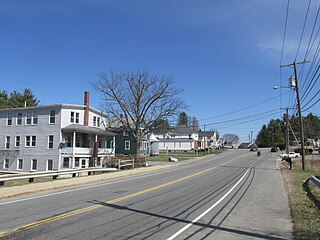
Blandford is a town in Hampden County, Massachusetts, United States. The population was 1,215 at the 2020 census. It is part of the Springfield, Massachusetts Metropolitan Statistical Area. It was the home of the Blandford Ski Area.

Cochituate is a census-designated place (CDP) in the town of Wayland in Middlesex County, Massachusetts, United States. The population was 6,927 at the 2020 census, out of 13,943 in the entire town of Wayland.

Pinehurst is an unincorporated village and census-designated place (CDP) in the town of Billerica, Middlesex County, Massachusetts, United States. The population was 7,368 at the 2020 census. It is in the southeastern part of town along Massachusetts Route 3A.
East Merrimack is a census-designated place (CDP) in the town of Merrimack, Hillsborough County, New Hampshire, United States. There is no village center named "East Merrimack"; rather, the CDP refers to the region of the town of Merrimack lying east of the F. E. Everett Turnpike, overlapping portions of the villages of Reeds Ferry, Thornton's Ferry, and the center of Merrimack. The population was 5,176 at the 2020 census, up from 4,197 at the 2010 census.

Lee is a census-designated place (CDP) located in the town of Lee in Berkshire County, Massachusetts, United States. The population was 2,051 at the 2010 census, out of 5,943 in the entire town of Lee.
Belchertown is a census-designated place (CDP) comprising the central village in the town of Belchertown in Hampshire County, Massachusetts, United States. The population was 2,899 at the 2010 census, out of a total town population of 14,649. It is part of the Springfield, Massachusetts Metropolitan Statistical Area.

Granby is a census-designated place (CDP) comprising the main village in the town of Granby in Hampshire County, Massachusetts, United States. The population of the CDP was 1,368 at the 2010 census, out of a total town population of 6,240. It is part of the Springfield, Massachusetts Metropolitan Statistical Area.

Ware is a census-designated place (CDP) comprising the main village in the town of Ware in Hampshire County, Massachusetts, United States. The population of the CDP was 6,170 at the 2010 census, out of a total town population of 9,872. It is part of the Springfield, Massachusetts Metropolitan Statistical Area.

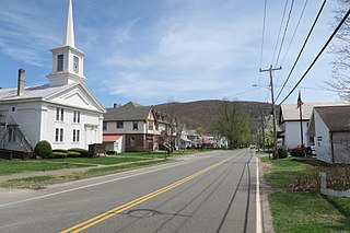
Winchester is a census-designated place (CDP) and the main village in the town of Winchester in Cheshire County, New Hampshire, United States. The population of the CDP was 1,606 at the 2020 census, compared to 4,150 in the entire town.

Derry is a census-designated place (CDP) in the town of Derry in Rockingham County, New Hampshire, United States. The CDP comprises the urban center of the town, as well as the village of East Derry and connected suburban areas. The population of the CDP was 22,879 at the 2020 census, out of 34,317 in the entire town.

Exeter is a census-designated place (CDP) and the main village in the town of Exeter, Rockingham County, New Hampshire, United States. The population of the CDP was 10,109 at the 2020 census, out of 16,049 in the entire town.

Hampton is a census-designated place (CDP) comprising the town center and surrounding developed areas of the town of Hampton, Rockingham County, New Hampshire, United States. The population of the CDP was 9,597 at the 2020 census, out of 16,214 in the entire town.

Bowmansville is an unincorporated community and census-designated place (CDP) in Brecknock Township, Lancaster County, Pennsylvania, United States. Bowmansville is home to the Pennsylvania Turnpike's Bowmansville Service Plaza. The population was 2,077 as of the 2010 census.

Hudson is a census-designated place (CDP) comprising the densely developed central part of the town of Hudson in Middlesex County, Massachusetts, United States. The population of the CDP was 15,749 at the 2020 census, out of 20,092 in the entire town.

Damariscotta is a census-designated place (CDP) comprising the main village of the town of Damariscotta in Lincoln County, Maine, United States. The population was 1,142 at the 2010 census, out of 2,218 in the entire town. In the 2000 census, the village was part of the Damariscotta-Newcastle CDP.
Russell is a census-designated place that comprises the populated center of the town of Russell in Hampden County, Massachusetts, United States. The population of the CDP was 786 at the 2010 census, out of 1,775 in the entire town of Russell. It is part of the Springfield, Massachusetts Metropolitan Statistical Area.

Swartzville is an unincorporated community and census-designated place (CDP) in East Cocalico Township, Lancaster County, Pennsylvania, United States. As of the 2010 census, the population was 2,283.

Huntington is a census-designated place (CDP) comprising the main village in the town of Huntington in Hampshire County, Massachusetts, United States. The population of the CDP was 936 at the 2010 census, out of a total town population of 2,180. It is part of the Springfield, Massachusetts Metropolitan Statistical Area.

Manchester is a census-designated place (CDP) in Hartford County, Connecticut, United States, comprising the urban center of the town of Manchester. As of the 2010 census, the population of the CDP was 30,577, out of 58,241 in the entire town.
Renaissance at Monroe is a planned community and census-designated place (CDP) in Monroe Township, Middlesex County, New Jersey, United States. It was first listed as a CDP in the 2020 census with a population of 637.


