The Hampden-Wilbraham region was once known as Minnechaug ("berry land" or "berry hill") to the Nipmuc Indians. They sold it to William Pynchon of Springfield in 1674, and the area then became known as Springfield Mountain, but it was not settled (as South Wilbraham) until about 1741. The first European settlers were the Stebbins and Hitchcock families. The first sawmill was erected on the Scantic in the vicinity of the V.F.W. building.
The "Rattlesnake Incident of 1761" is thought to have occurred on farmland in what is now Hampden on August 7 of that year, when 22-year-old Timothy Merrick was killed by a snakebite while mowing his father's field—an event immortalized by "On Springfield Mountain", among the earliest ballads ever written in North America, and the basis for the modern folk song "Rattlesnake Mountain".
The settlement was built on the banks of the Scantic River. The first grist and saw mills required the waters of the Scantic to provide them with power. Since their businesses had to be near the river, so also did the owners need to be close to their mills. So many of the earliest homes were built bordering the river or its tributaries.
During the first hundred years as South Wilbraham, Hampden was an agricultural town with Wilbraham as the "mother" town.
At the time of separation from Wilbraham in 1878, industries were becoming active in Hampden. Fires leveled some of the largest mills—the Lacowsic in 1892, the Ravine in 1904—and with the lack of marketing, other businesses failed. The advent of automobiles enabled men to find occupations outside of the town. There was then the trend back to agriculture, with many orchards developed throughout the area, with the herds of milk-producing cows, and with farmers growing their many crops.
At about this time, numerous summer type vacation homes were built for Springfield residents who vacationed in Hampden. From these, many year-round homes developed.
Now the mills and quarries, orchards and cows are almost gone, and Hampden has become a residential town.
Hampden erected one of the first World War I monuments, only months after the conclusion of the War, in January 1920, which still stands on the village green.
H.P. Lovecraft's experience traveling through Hampden inspired his 1928 supernatural horror story "The Dunwich Horror".[3] The fictional town of Dunwich is based on Hampden and the surrounding area.
In August 1955, Hampden was hit by Hurricane Diane. Flooding was the major cause of damage; most bridges were washed away.
Since 2000, Hampden residents have acquired over 100 acres (0.40km2) of open space and park land, including the peak of Minnechaug Mountain, one of the higher hills in town. A trailhead and parking lot on South Road was created. Minnechaug Mountain trails can also be accessed from Old Coach Road, and, except for the fall Turkey Shoot season, from the VFW parking lot on Main St.
In September 2004, an arson[4] fire hit Laughing Brook Wildlife Sanctuary (located on Main Street in Hampden). The building was dedicated to author Thornton Burgess after his death. The headquarters building was burnt down, but Burgess' original home on the property was untouched by the fire, and still stands.
After a week of rain and an extremely hard rain on the early morning of October 9, 2005, the Scantic River and many of its tributaries overflowed their banks. Many homes and businesses were flooded. The VFW bridge was washed away.
Geography
According to the United States Census Bureau, the town has a total area of 19.6 square miles (51km2), of which 19.6 square miles (51km2) is land and 0.05% is water. Hampden is located at the eastern edge of the Connecticut River Valley. Hills rise up to over 1,000 feet (300m) above sea level, from the valley elevation of 150 to 250 feet (46 to 76m). The highest peaks are Pine Mountain and Rattlesnake Peak, both at 1,070 feet (330m). The town has no large bodies of water, but has several brooks which eventually drain into the Connecticut River.
Hampden is one of sixteen towns in Massachusetts that has no numbered highways or state routes. Of these, half are on islands, and one is the North Shore town of Nahant. Of the remainder, Hampden is the easternmost town to have this distinction. The town does not have stoplights. The nearest state route, Route 83, misses the town by less than one-tenth of a mile. The town lies 10 miles (16km) south of two exits of Interstate 90, and approximately 9 miles (14km) east of Interstate 91. There are no means of mass transportation in the town. The nearest rail service is in Springfield, and the nearest national air service is at Bradley International Airport in Connecticut.
Climate
Winters are variable, sometimes fairly mild, with daytime high temperatures in the 30s, though sometimes rather cold. A record cold temperature of −40 degrees Fahrenheit (−40°C) was recorded at the Hampden Post Office, and at other points in the village of Hampden, on an early morning in January 1960. In late July 2006, the temperature reached 100 degrees on a hot afternoon. These are the known recent extremes of temperature in Hampden. On March 14, 1995, after several snowstorms and little melting, a snow depth of 28" was recorded. However, some winters there is little snow. In the summer there are hot and humid periods, which alternate with warm and dry periods.
As of the census[13] of 2010, there were 5,109 people, 1,887 households, and 1,467 families residing in the town. The population density was 260.7 inhabitants per square mile (100.7/km2). There were 1,937 housing units at an average density of 98.82 per square mile (38.15/km2). The racial makeup of the town was 96.70% White, 0.50% African American, 0.1% Native American, 1.4% Asian, 0.02% Pacific Islander, 0.40% from other races, and 1.00% from two or more races. Hispanic or Latino of any race were 1.50% of the population.
There were 1,887 households, out of which 32.1% had children under the age of 18 living with them, 66.1% were married couples living together, 7.0% had a female householder with no husband present, and 22.3% were non-families. 17.9% of all households were made up of individuals, and 9.8% had someone living alone who was 65 years of age or older. The average household size was 2.66 and the average family size was 3.01.
In the town, the population was spread out, with 23.7% under the age of 18, 4.5% from 18 to 24, 18.1% from 25 to 44, 35.3% from 45 to 64, and 18.5% who were 65 years of age or older. The median age was 47.1 years.
The median income for a household in the town was $81,130, and the median income for a family was $86,848.
According to the 2000 Census, males had a median income of $49,320 versus $30,870 for females. The per capita income for the town was $26,690. About 1.4% of families and 2.2% of the population were below the poverty line, including 1.4% of those under age 18 and 3.0% of those age 65 or over.
Government
Hampden's government consists of various elected and appointed boards. There is a three-member Board of Selectmen/Board of Health, Planning Board, Conservation Committee, Board of Assessors, Park and Recreation Board, and various other boards and committees common to town governments throughout New England. Hampden's Board of Selectmen is currently composed of Selectman Chair Don Davenport, Selectman John Flynn, who also serves as the Board of Health chair, and Selectman Craig Rivest.
Voter registration and party enrollment as of October 17, 2018[14]
The Hampden Public Library opened in 1891.[15][16] For a short time in 2005 and 2006, the town library and senior center were closed down after budget increases were voted for the school district within the main budget, but the existing library and senior center funding was put on a property tax increase override vote, which failed. Because of this, although residents could read and research at neighboring libraries, town residents could no longer borrow books from many libraries in other towns. The library and senior center were reopened in the summer of 2006. In fiscal year 2008, the town of Hampden spent 0.85% ($76,862) of its budget on its public library—approximately $14 per person.[17]
Education
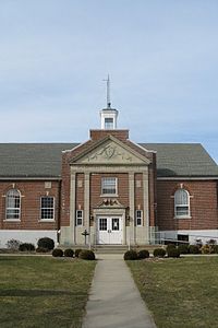
Green Meadows Elementary School opened in 1956. In 1956, Hampden joined with the neighboring town of Wilbraham in a unified school district for grades 9–12. The two towns built Minnechaug Regional High School in Wilbraham, which opened in 1959. Thorton W. Burgess Middle School was built in 1967, and in 2018, was shut down due to decreased enrollment.
Places of worship
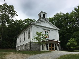
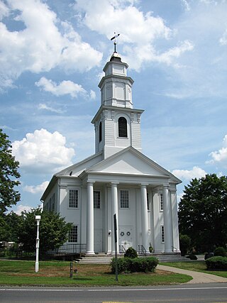
Hampden has three churches of the following faiths: Baptist, Roman Catholic, and Federated which is the (combined United Church of Christ, Congregational and United Methodist). The Roman Catholic church is named St.Mary's. The Baptist Church is named Bethlehem Church. The Federated church is named Federated Community Church.
The former site of Laughing Brook Wildlife Sanctuary, which was home of author Thornton Burgess.
Minnechaug Mountain: Hiking trails and nature walks on a town owned reserve. Parking at the trailhead on South Rd.
Algonquin Trail: Also known as the old "Boy Scout Trail", or the "Ridge Trail", it traverses the town from north to south. Goes through the Minnechaug Mtn. reserve. It is fragmented in some areas, but as of 2008, it is being marked and improved, and should connect with other regional trail systems through the towns of Wilbraham, MA, and Somers, CT, sometime in the future.
Hollow Road: A notorious, thought-to-be haunted road between Hampden and the neighboring town of Wilbraham, MA. The road is closed on the Wilbraham side.
Rock-A-Dundee Road: An allegedly haunted road. The road has long been the setting of numerous local urban legends and ghost stories
Related Research Articles
Hampden County is a non-governmental county located in the Pioneer Valley of the U.S. state of Massachusetts, in the United States. As of the 2020 census, Hampden County's population was 465,825. Its traditional county seat is Springfield, the Connecticut River Valley's largest city, and economic and cultural capital; with an estimated population of 154,758, approximately one-third of Hampden County residents live in Springfield.
Mount Washington is a town in Berkshire County, Massachusetts, United States. It is part of the Pittsfield, Massachusetts Metropolitan Statistical Area. The population was 160 at the 2020 census, making it the least populous town in Berkshire County and, after Gosnold and Monroe, the third least populous in Massachusetts. The name of the town is a tribute to George Washington, who at the time of incorporation was Commander-in-Chief of the Continental Army during the American Revolutionary War.
Otis is a town in Berkshire County, Massachusetts, United States. It is part of the Pittsfield, Massachusetts, Metropolitan Statistical Area. The population was 1,634 at the 2020 census.
Sandisfield is a town in Berkshire County, Massachusetts, United States. It is part of the Pittsfield, Massachusetts Metropolitan Statistical Area. The population was 989 at the 2020 census.
Buckland is a town in Franklin County, Massachusetts, United States. The population was 1,816 at the 2020 census. The town shares the village of Shelburne Falls with neighboring Shelburne. The town center at Shelburne Falls is the western end of the Bridge of Flowers, a local tourist attraction.
Agawam is a city in Hampden County, Massachusetts, United States. The population was 28,692 at the 2020 census. Agawam sits on the western side of the Connecticut River, directly across from Springfield. It is considered part of the Springfield Metropolitan Statistical Area, which is contiguous with the Knowledge Corridor area, the second-largest metropolitan area in New England. Agawam contains a subsection, Feeding Hills. The Six Flags New England amusement park is located in Agawam, on the banks of the Connecticut River.
East Longmeadow is a town in Hampden County, Massachusetts, United States, situated in the Pioneer Valley region of Western Massachusetts. It had a population of 16,430 at the 2020 census. East Longmeadow is 5 mi (8.0 km) southeast of downtown Springfield, part of the Springfield Metropolitan Statistical Area. Additionally, the town is 25 mi (40 km) north of Hartford, 88 mi (142 km) southwest of Boston, and 142 mi (229 km) northeast of New York City.
Granville is a town in Hampden County, Massachusetts, United States. The population was 1,538 at the 2020 census. It is part of the Springfield, Massachusetts Metropolitan Statistical Area. The town is named for John Carteret, 2nd Earl Granville.
Ludlow is a New England town in Hampden County, Massachusetts, United States. The population was 21,002 as of the 2020 census, and it is considered part of the Springfield Metropolitan Statistical Area. Located just northeast of Springfield across the Chicopee River, it is one of the city's suburbs. It has a sizable and visible Portuguese and Polish community.
Monson is a town in Hampden County, Massachusetts, United States. The population was 8,150 at the 2020 census. It is part of the Springfield, Massachusetts Metropolitan Statistical Area.
Montgomery is a town in Hampden County, Massachusetts, United States. The population was 819 at the 2020 census. It is part of the Springfield, Massachusetts Metropolitan Statistical Area.
Southwick is a town in Hampden County, Massachusetts, United States. The population was 9,232 at the 2020 census, down from 9,502 at the 2010 census. It is part of the Springfield, Massachusetts Metropolitan Statistical Area.
Wales is a town in Hampden County, Massachusetts, United States. The population was 1,838 at the 2020 census. It is part of the Springfield, Massachusetts Metropolitan Statistical Area.
Westfield is a city in Hampden County, in the Pioneer Valley of western Massachusetts, United States. Westfield was first settled by Europeans in 1660. It is part of the Springfield, Massachusetts Metropolitan Statistical Area. The population was 40,834 at the 2020 census.
West Springfield is a city in Hampden County, Massachusetts, United States. It is part of the Springfield, Massachusetts Metropolitan Statistical Area. The population was 28,835 at the 2020 United States Census. The city is also known as "West Side", in reference to the fact that it is on the western side of the Connecticut River from Springfield, a fact which played a major part in the town's early history.
Holland is a town in Hampden County, Massachusetts, United States. The population was 2,603 at the 2020 census. It is part of the Springfield, Massachusetts Metropolitan Statistical Area.
Wilbraham is a census-designated place (CDP) in the town of Wilbraham in Hampden County, Massachusetts, United States. The population was 3,915 at the 2010 census, out of 14,868 in the town as a whole. It is part of the Springfield, Massachusetts Metropolitan Statistical Area.
Wilbraham is a town in Hampden County, Massachusetts, United States. It is a suburb of the City of Springfield, and part of the Springfield Metropolitan Statistical Area. The population was 14,613 at the 2020 census.
The Scantic River is a river that flows through the states of Massachusetts and Connecticut. It is a tributary to the Connecticut River.
The Springfield metropolitan area, also known as Greater Springfield, is a region that is socio-economically and culturally tied to the City of Springfield, Massachusetts. The U.S. Office of Management and Budget defines the Springfield, MA Metropolitan Statistical Area (MSA) as consisting of three counties in Western Massachusetts. As of April 1, 2020, the metropolitan area's population was estimated at 699,162, making it the 88th-largest metropolitan area in the United States.
↑ "1950 Census of Population"(PDF). 1: Number of Inhabitants. Bureau of the Census. 1952. Section 6, Pages 21-10 and 21-11, Massachusetts Table 6. Population of Counties by Minor Civil Divisions: 1930 to 1950. Retrieved July 12, 2011.{{cite journal}}: Cite journal requires |journal= (help)
↑ "1920 Census of Population"(PDF). Bureau of the Census. Number of Inhabitants, by Counties and Minor Civil Divisions. Pages 21-5 through 21-7. Massachusetts Table 2. Population of Counties by Minor Civil Divisions: 1920, 1910, and 1920. Retrieved July 12, 2011.
↑ "1890 Census of the Population"(PDF). Department of the Interior, Census Office. Pages 179 through 182. Massachusetts Table 5. Population of States and Territories by Minor Civil Divisions: 1880 and 1890. Retrieved July 12, 2011.
↑ July 1, 2007, through June 30, 2008; cf. The FY2008 Municipal Pie: What's Your Share? Commonwealth of Massachusetts, Board of Library Commissioners. Boston: 2009. Available: Municipal Pie ReportsArchived January 23, 2012, at the Wayback Machine . Retrieved August 4, 2010
This page is based on this Wikipedia article Text is available under the CC BY-SA 4.0 license; additional terms may apply. Images, videos and audio are available under their respective licenses.