
The Semi-Automatic Ground Environment (SAGE) was a system of large computers and associated networking equipment that coordinated data from many radar sites and processed it to produce a single unified image of the airspace over a wide area. SAGE directed and controlled the NORAD response to a possible Soviet air attack, operating in this role from the late 1950s into the 1980s. Its enormous computers and huge displays remain a part of Cold War lore, and after decommissioning were common props in movies such as Dr. Strangelove and Colossus, and on science fiction TV series such as The Time Tunnel.

North American Aerospace Defense Command, known until March 1981 as the North American Air Defense Command, is a combined organization of the United States and Canada that provides aerospace warning, air sovereignty, and protection for Canada and the continental United States.

The Cheyenne Mountain Complex is a United States Space Force installation and defensive bunker located in unincorporated El Paso County, Colorado, next to the city of Colorado Springs, at the Cheyenne Mountain Space Force Station, which hosts the activities of several tenant units. Also located in Colorado Springs is Peterson Space Force Base, where the North American Aerospace Defense Command (NORAD) and United States Northern Command (USNORTHCOM) headquarters are located.

PAVE PAWS is a complex Cold War early warning radar and computer system developed in 1980 to "detect and characterize a sea-launched ballistic missile attack against the United States". The first solid-state phased array deployed used a pair of Raytheon AN/FPS-115 phased array radar sets at each site to cover an azimuth angle of 240 degrees. In accordance with the Joint Electronics Type Designation System, the "AN/FPS-115" designation represents the 115th design of an Army-Navy fixed radar(pulsed) electronic device for searching. Two sites were deployed in 1980 at the periphery of the contiguous United States, then two more in 1987–95 as part of the United States Space Surveillance Network. One system was sold to Taiwan and is still in service.
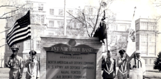
Ent Air Force Base was a United States Air Force base located in the Knob Hill neighborhood of Colorado Springs, Colorado. A tent city, established in 1943 during construction of the base, was initially commanded by Major General Uzal Girard Ent (1900–1948), for whom the base is named. The base was opened in 1951.
The RCA 474L Ballistic Missile Early Warning System was a United States Air Force Cold War early warning radar, computer, and communications system, for ballistic missile detection. The network of twelve radars, which was constructed beginning in 1958 and became operational in 1961, was built to detect a mass ballistic missile attack launched on northern approaches [for] 15 to 25 minutes' warning time also provided Project Space Track satellite data.

Aerospace Defense Command was a major command of the United States Air Force, responsible for air defense of the continental United States. It was activated in 1968 and disbanded in 1980. Its predecessor, Air Defense Command, was established in 1946, briefly inactivated in 1950, reactivated in 1951, and then redesignated Aerospace rather than Air in 1968. Its mission was to provide air defense of the Continental United States (CONUS). It directly controlled all active measures, and was tasked to coordinate all passive means of air defense.

The 26th Air Division is an inactive United States Air Force organization. Its last assignment was with Air Defense Tactical Air Command, assigned to First Air Force, being stationed at March Air Force Base, California. It was inactivated on 30 September 1990.

The 28th Air Division is an inactive United States Air Force organization. Its last assignment was with Air Defense Tactical Air Command at Tinker Air Force Base, Oklahoma. It was inactivated on 29 May 1992.

The 33rd Air Division is an inactive United States Air Force organization. Its last assignment was with Air Defense Command, assigned to First Air Force, being stationed at Fort Lee Air Force Station, Virginia. It was inactivated on 19 November 1969.

The 1st Space Operations Squadron is a United States Space Force unit responsible for space-based space domain awareness. Located at Schriever Space Force Base, Colorado, the squadron operates the Space Based Space Surveillance system, the Advanced Technology Risk Reduction system, the Operationally Responsive Space-5 satellite, and the Geosynchronous Space Situational Awareness Program.
Space Track may refer to various facilities and systems for Project Space Track and other space surveillance operations :

The Chidlaw Building is a former United States Air Force facility located in the Knob Hill neighborhood of Colorado Springs, Colorado. The building was close to, but not within, the Ent Air Force Base complex, and was leased by the military for several decades, housing headquarters for several military commands, starting with the Air Defense Command (ADC) and the North American Aerospace Defense Command (NORAD). When Chidlaw was completed, personnel from multiple locations, including the Ent Air Force Base, were consolidated into the new building.

Cheyenne Mountain Space Force Station (CMSFS) is located in Cheyenne Mountain on the Front Range of the Rocky Mountains in unincorporated El Paso County, Colorado, next to Colorado Springs, The Cheyenne Mountain Complex, an underground facility within Cheyenne Mountain SFS, was first built for the North American Aerospace Defense Command (NORAD) Combat Operations Center, though NORAD moved day-to-day operations to its headquarters on Peterson AFB in 2006. However, day-to-day operations were moved back in 2011 after a major overhaul and renovation.
Space Detection and Tracking System, or SPADATS, was built in 1960 to integrate defense systems built by different branches of the United States Armed Forces and was placed under North American Aerospace Defense Command (NORAD). The Air Force had a program called Spacetrack, which was a network of space-probing cameras and radar. The Navy had a system called SPASUR, a space surveillance system that was "an electronic fence" the protected the southern United States.
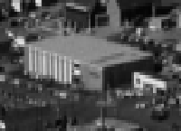
The Federal Building, originally the Burroughs Building, was a Cold War military computer systems building on the Ent Air Force Base in Colorado Springs. It was built in 1962 to be used by Burroughs Corporation for its project to build an automated facility to take input, like satellite and radar information, and instantaneously assess its degree of combat importance. The program was designed in conjunction with Air Force 425L System Project engineers and was an important component in North American Aerospace Defense Command (NORAD)'s command and control system. It was an Ent Air Force Base building until 1975 when the base was inactivated. It then became an off-base installation to the Peterson Air Force Base. Over the next several decades there were varying uses for the building by the federal government. After 2007, the building was vacated and in 2009 it was sold.
Continental Air Defense Command (CONAD) was a Unified Combatant Command of the United States Department of Defense, tasked with air defense for the Continental United States. It comprised Army, Air Force, and Navy components. It included Army Project Nike missiles anti-aircraft defenses and USAF interceptors. The primary purpose of continental air defense during the CONAD period was to provide sufficient attack warning of a Soviet bomber air raid to ensure Strategic Air Command could launch a counterattack without being destroyed. CONAD controlled nuclear air defense weapons such as the 10 kiloton W-40 nuclear warhead on the CIM-10B BOMARC. The command was disestablished in 1975, and Aerospace Defense Command became the major U.S. component of North American Air Defense Command (NORAD).

The Missile Warning Center (MWC) is a center that provides missile warning and defense for United States Space Command's Combined Force Space Component Command, incorporating both space-based and terrestrial sensors. The MWC is located at Cheyenne Mountain Space Force Station.

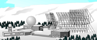
Eglin AFB Site C-6 is a United States Space Force radar station which houses the AN/FPS-85 phased array radar, associated computer processing system(s), and radar control equipment designed and constructed for the U. S. Air Force by the Bendix Communications Division, Bendix Corporation. Commencing operations in 1969, the AN/FPS-85 was the first large phased array radar. The entire radar/computer system is located at a receiver/transmitter building and is supported by the site's power plant, fire station, 2 water wells, and other infrastructure for the system. As part of the US Space Force's Space Surveillance Network its mission is to detect and track spacecraft and other manmade objects in Earth orbit for the Combined Space Operations Center satellite catalogue. With a peak radiated power of 32 megawatts the Space Force claims it is the most powerful radar in the world, and can track a basketball-sized object up to 22,000 nautical miles (41,000 km) from Earth. In accordance with the Joint Electronics Type Designation System, the radar's "AN/FPS-85" designation represents the 85th design of an Army-Navy fixed radar(pulsed) electronic device for searching.

Construction of the Cheyenne Mountain Complex began with the excavation of Cheyenne Mountain in Colorado Springs, Colorado on May 18, 1961. It was made fully operational on February 6, 1967. It is a military installation and hardened nuclear bunker from which the North American Aerospace Defense Command was headquartered at the Cheyenne Mountain Complex. The United States Air Force has had a presence at the complex since the beginning, the facility is now the Cheyenne Mountain Space Force Station, which hosts other military units, including NORAD.
