The River Welland is a lowland river in the east of England, some 65 miles (105 km) long. It drains part of the Midlands eastwards to The Wash. The river rises in the Hothorpe Hills, at Sibbertoft in Northamptonshire, then flows generally northeast to Market Harborough, Stamford and Spalding, to reach The Wash near Fosdyke. It is a major waterway across the part of the Fens called South Holland, and is one of the Fenland rivers which were laid out with washlands. There are two channels between widely spaced embankments with the intention that flood waters would have space in which to spread while the tide in the estuary prevented free egress. However, after the floods of 1947, new works such as the Coronation Channel were constructed to control flooding in Spalding and the washes are no longer used solely as pasture, but may be used for arable farming.

Saint Anthony Falls, or the Falls of Saint Anthony located at the northeastern edge of downtown Minneapolis, Minnesota, is the only natural major waterfall on the Mississippi River. Throughout the mid-to-late 1800’s, various dams were built atop the east and west faces of the falls to support the milling industry that spurred the growth of the city of Minneapolis. In 1880, the central face of the falls was reinforced with a sloping timber apron to stop the upstream erosion of the falls. In the 1950s, the apron was rebuilt with concrete, which makes up the most visible portion of the falls today. A series of locks were constructed in the 1950s and 1960s to extend navigation to points upstream.

Bonneville Lock and Dam consists of several run-of-the-river dam structures that together complete a span of the Columbia River between the U.S. states of Oregon and Washington at River Mile 146.1. The dam is located 40 miles (64 km) east of Portland, Oregon, in the Columbia River Gorge. The primary functions of Bonneville Lock and Dam are electrical power generation and river navigation. The dam was built and is managed by the United States Army Corps of Engineers. At the time of its construction in the 1930s it was the largest water impoundment project of its type in the nation, able to withstand flooding on an unprecedented scale. Electrical power generated at Bonneville is distributed by the Bonneville Power Administration. Bonneville Lock and Dam is named for Army Capt. Benjamin Bonneville, an early explorer credited with charting much of the Oregon Trail. The Bonneville Dam Historic District was designated a National Historic Landmark District in 1987.
The River Nar is a river in England, a tributary of the River Great Ouse. It rises at Mileham near Litcham in Norfolk and flows 15 miles west through Castle Acre and Narborough, joining the Ouse at King's Lynn. It has had a variety of alternative names, such as the Setch, the Sandringham, and Lynn Flu, though these are rarely, if ever, used today. In 2011 the Nar was recognised by the Environment Agency as one of the top ten most improved rivers in England and Wales.
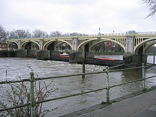
Richmond Lock and Footbridge is a lock, rising and falling low-tide barrage integrating controlled sluices and pair of pedestrian bridges on the River Thames in south west London, England and is a Grade II* listed structure. It is the furthest downstream of the forty-five Thames locks and the only one owned and operated by the Port of London Authority. It was opened in 1894 and is north-west of the centre of Richmond in a semi-urban part of south-west London. Downstream are Syon Park and Kew Gardens on opposite banks. It connects the promenade at Richmond with the neighbouring district of St. Margarets on the west bank during the day and is closed at night to pedestrians – after 19:30 GMT or after 21:30 when BST is in use. At high tide the sluice gates are raised and partly hidden behind metal arches forming twin footbridges.

The Roxburgh Dam is the earliest of the large hydroelectric projects in the lower half of the South Island of New Zealand. It lies across the Clutha River / Mata-Au, some 160 kilometres (99 mi) from Dunedin, some 9 kilometres (5.6 mi) to the north of the town of Roxburgh. The settlement of Lake Roxburgh Village is close to the western edge of the dam.

Pathfinder Dam is a masonry dam, located on the North Platte River, approximately 47 miles (76 km) southwest of Casper, Wyoming. It was originally constructed between 1905 and 1909 as part of the North Platte Project and has been modified several times since then. It is included on the National Register of Historic Places. Construction of the dam created Pathfinder Reservoir which provides water storage for 226,000 acres (910 km2) of irrigation in Wyoming and Nebraska. The dam is named for General John Charles Fremont, who had explored the area in 1842 and was nicknamed the "Pathfinder of the West."
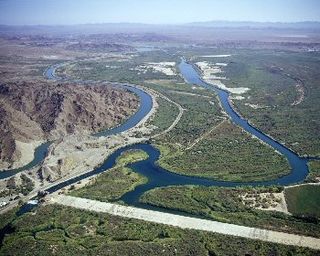
The Laguna Diversion Dam is a rock-filled diversion dam on the Colorado River. It is located 13 miles northeast of Winterhaven, CA–Yuma, AZ on Imperial County route S24. Constructed between 1903 and 1905, the dam was the first dam built on the Colorado River and subsequently ended boat travel to the north.

Lock and Dam No. 19 is a lock and dam located on the Upper Mississippi River near Keokuk, Iowa. In 2004, the facility was listed in the National Register of Historic Places as Lock and Dam No. 19 Historic District, #04000179 covering 1,605 acres (650 ha), 7 buildings, 12 structures, 1 object. The lock is owned and operated by the U.S. Army Corps of Engineers. The dam is owned and operated by Ameren Missouri.

The Ranapratap Sagar Dam is a gravity masonry dam of 53.8 metres (177 ft) height built on the Chambal River at Rawatbhata in Rajasthan in India. It is part of integrated scheme of a cascade development of the river involving four projects starting with the Gandhi Sagar Dam in the upstream reach in Madhya Pradesh and the Jawahar Sagar Dam on the downstream with a terminal structure of the Kota Barrage in Rajasthan for irrigation.
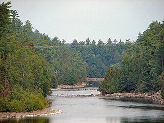
The Kipawa River is a short river in western Quebec, Canada. It is mostly an undeveloped river but the larger lakes have dams, fishing camps, and cottages on their shores. The communities of Kipawa and Laniel are located on Lake Kipawa. Also much logging takes place within its watershed basin, which is consequently crisscrossed by many bush roads. Route 101 crosses the river at Laniel.
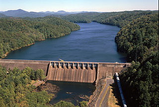
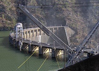
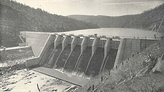
Apalachia Dam is a hydroelectric dam on the Hiwassee River in Cherokee County, in the U.S. state of North Carolina. The dam is the lowermost of three dams on the river owned and operated by the Tennessee Valley Authority, which built the dam in the early 1940s to provide emergency power for aluminum production during World War II. While the dam is in North Carolina, an 8.3-mile (13.4 km) underground conduit carries water from the dam's reservoir to the powerhouse located 12 miles (19 km) downstream across the state line in Polk County, Tennessee. The dam and associated infrastructure were listed on the National Register of Historic Places in 2017.
Calderwood Dam is a hydroelectric dam located along the Little Tennessee River in Blount and Monroe counties, in the U. S. state of Tennessee. Completed in 1930, the dam is owned and maintained by Tapoco, a subsidiary of the Aluminum Company of America (Alcoa), although the Tennessee Valley Authority controls the dam's reservoir levels from Fontana Dam further upstream. Calderwood Dam is named for Alcoa engineer Isaac Glidden Calderwood (1871–1941), who supervised much of the company's early Little Tennessee River operations.

Arrowrock Dam is a concrete arch dam on the Boise River, in the U.S. state of Idaho. It opened in 1915 and is located on the border between Boise County and Elmore County, upstream of the Lucky Peak Dam and reservoir. The spillway elevation for Arrowrock is 3,219 feet (981 m) above sea level and its primary purpose is to provide irrigation water for agriculture. The dam was designated as a National Historic Civil Engineering Landmark by the American Society of Civil Engineers in 2016.
Ocoee Dam No. 3 is a hydroelectric dam on the Ocoee River in Polk County, in the U.S. state of Tennessee. It is one of four dams on the Toccoa/Ocoee River owned and operated by the Tennessee Valley Authority, which built the dam in the early 1940s to meet emergency demands for electricity during World War II. The dam impounds the 360-acre (150 ha) Ocoee No. 3 Reservoir, which stretches 11 miles (18 km) upriver to the Tennessee-Georgia state line. Ocoee No. 3's powerhouse is actually located several miles downstream from the dam, and is fed by a 2.5-mile (4.0 km) conduit that carries water to it from the reservoir.

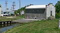
A gatehouse, gate house, outlet works or valve house for a dam is a structure housing sluice gates, valves, or pumps. Many gatehouses are strictly utilitarian, but especially in the nineteenth century, some were very elaborate.

The Governor Bento Munhoz da Rocha Netto Hydroelectric Plant, formerly known as Foz do Areia, is dam and hydroelectric power plant on the Iguazu River near Foz do Areia in Paraná, Brazil. It is the furthest dam upstream of the Iguazu Falls and was constructed between 1976 and 1980. The power station has a 1,676 megawatts (2,248,000 hp) capacity and is supplied with water by a concrete face rock-fill embankment dam.

Lake Cachi is an artificial lake in central Costa Rica created by the Cachí Dam, an arch dam north of Tapantí National Park, to the east-southeast of Cartago in Cartago Province. The main town is Cachí, away from the east bank of the lake. Built in the 1970s, it was one of the first hydroelectric projects in Costa Rica. It has an installed capacity of 102 MW with three units of 34 MW capacity each.

The Devil's Gate-Weber Hydroelectric Power Plant was built in 1909-1910 on the Weber River in northeastern Utah, United States, about 10 miles (16 km) southeast of Ogden. It was built by the Utah Light and Railway Company under the direction of E.H. Harriman, a director of the Union Pacific Railroad. It was one of the first powerplants in Utah designed to feed an electrical grid rather than as a source of power of a single locality.

Seattle Municipal Light and Power Plant, also known as Cedar Falls Historic District, is a public hydroelectric plant near North Bend, Washington operated by Seattle City Light. The plant was the first publicly-owned electrical generating plant for Seattle and one of the earliest in the country for a municipality of its size. It was listed on the National Register of Historic Places in 1997.