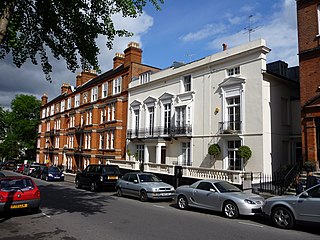
Hampstead is an area in London, England, which lies four miles northwest of Charing Cross, and extends from the A5 road to Hampstead Heath, a large, hilly expanse of parkland. The area forms the northwest part of the London Borough of Camden, a borough in Inner London which for the purposes of the London Plan is designated as part of Central London.

Highgate is a suburban area of London at the northeastern corner of Hampstead Heath, 4+1⁄2 miles north-northwest of Charing Cross.

Samuel Augustus Barnett was a Church of England cleric and social reformer who was particularly associated with the establishment of the first university settlement, Toynbee Hall, in east London in 1884. He is often referred to as Canon Barnett, having served as Canon of Westminster Abbey from 1906 until death.
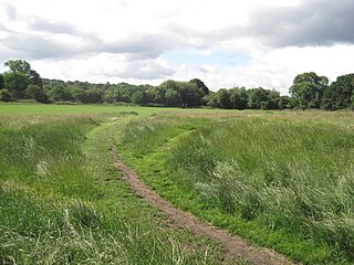
Hampstead Heath is an ancient heath in London, spanning 320 hectares. This grassy public space sits astride a sandy ridge, one of the highest points in London, running from Hampstead to Highgate, which rests on a band of London Clay. The heath is rambling and hilly, embracing ponds, recent and ancient woodlands, a lido, playgrounds, and a training track, and it adjoins the former stately home of Kenwood House and its estate. The south-east part of the heath is Parliament Hill, from which the view over London is protected by law.

Gospel Oak is an inner urban area of north west London in the London Borough of Camden at the very south of Hampstead Heath. The neighbourhood is positioned between Hampstead to the north-west, Dartmouth Park to the north-east, Kentish Town to the south-east, and Belsize Park to the south-west. Gospel Oak lies across the NW5 and NW3 postcodes and is served by Gospel Oak station on the London Overground.
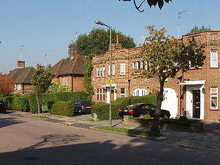
Hampstead Garden Suburb is an elevated suburb of London, north of Hampstead, west of Highgate and east of Golders Green. It is known for its intellectual, liberal, artistic, musical and literary associations. It is an example of early twentieth-century domestic architecture and town planning in the London Borough of Barnet, northwest London.
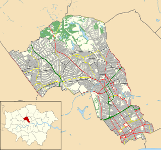
The London Borough of Camden is in percentage terms the second-greenest of the Inner London boroughs. It contains most of the swathe of land Hampstead Heath and many smaller green spaces. The Central London part of the borough, south of Euston Road, is characterised by its elegant garden squares with large instances: Tavistock Square and Bedford Square. In this part runs the Regent's Canal around the top edge of Regent's Park, a little of which is in Camden, including all of associated Primrose Hill. Highgate Cemetery is in Camden but Highgate Wood is in the neighbouring borough of Haringey.

The London Borough of Camden is a borough in Inner London, England. Camden Town Hall, on Euston Road, lies 1.4 mi (2.3 km) north of Charing Cross. The borough was established on 1 April 1965 from the former metropolitan boroughs of Holborn, St Pancras and Hampstead.

Romford Garden Suburb, is a late-Edwardian housing development in Gidea Park, in the London Borough of Havering. The object of the new suburb, which was built on land belonging to Gidea Hall, then occupied by the Liberal politician Herbert Raphael, was, according to his parliamentary colleague John Burns, to "provide families with a well-built, modern home regardless of class or status" and "to bring the towns into the country and the country into the towns".
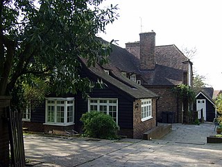
Wyldes Farm is a Grade II* listed former farmhouse in the hamlet of North End, Hampstead, in the London Borough of Barnet, NW11.

Well Walk is a street in Hampstead, England in the London Borough of Camden. It runs southwestwards from Hampstead Heath to Flask Walk which then continues on towards the centre of Hampstead Village around the Hampstead tube station. It takes its name from the historic Hampstead Wells.

Well Road is a street in Hampstead, England in the London Borough of Camden. It runs westwards from Hampstead Heath to New End Square. Well Walk runs parallel to its south and the two are linked by Wells Passage. When the Hampstead Wells were in existence, a large pump room and assembly room were located on Well Walk, with the water supplied from the headspring on Well Road.

New End Square is a square in Hampstead, in the London Borough of Camden. It dates back to the early eighteenth century when it was located close to the Hampstead Wells spa on the adjacent Well Walk. Despite its name it is not rectangular. At its northern end is the Old White Bear pub dating back to 1704, on the corner with Well Road. Its southern end is at the junction between Flask Walk and Well Walk. New End street curls off from one corner of the square, eventually heading west to Heath Street.

Pond Street is located in Hampstead in the London Borough of Camden. It runs eastwards from Rosslyn Hill to South End Green, located in the old "South End" of the settlement. The street takes its name from an ancient pond at South End Green, a source of the River Fleet, and has been known by this name since at least 1678. The pond survived into the Victorian era.
North End Way is a street in Hampstead in the London Borough of Camden, today a stretch of the A502 road. At the boundary with the London Borough of Barnet it becomes North End Road running northwards into Golders Green where it terminates at the junction with Finchley Road, by the tube station. North End Way passes through Hampstead Heath.
Hampstead Way is a street at the northern edge of Hampstead. It is located primarily in the London Borough of Barnet although its southern end forms a border with the London Borough of Camden in which the rest of Hampstead is located. In the south it is part of the old hamlet of North End, which marked the northern boundary of Hampstead, but then curves northwards and follows the edge of Hampstead Heath into Golders Green and Hampstead Garden Suburb. The southern end leads off North End Way.

North End is located on the northern edge of Hampstead, just south of Golders Green. For much of its existence it was a rural hamlet but is now part of suburban London. Hampstead Heath lies both east and west of the settlement, while Hampstead Garden Suburb is to its northeast connected by Hampstead Way. It sits on the border between the London Borough of Camden and the London Borough of Barnet. North End Way connects it with Hampstead Village.

Heath Street is in Hampstead in the London Borough of Camden, part of the A502 road for much of its route. It runs from the centre of Hampstead Village northwards towards Hampstead Heath. By Jack Straw's Castle it divides into North End Way heading towards North End and Spaniards Road heading towards Hampstead Garden Suburb and Highgate via Hampstead Lane. Streets running off it include Church Row, New End, Holly Hill, Hampstead Grove and Hampstead Square.

Hampstead Grove is a street in Hampstead in the London Borough of Camden. It heads northwards from Holly Hill running towards Hampstead Heath, but curving back towards Lower Terrace which connects it to the Heath. It runs roughly parallel to Heath Street to its east. It takes its name from the groves of trees that marked the landscape.

Highgate West Hill is a street in Highgate, London. Located in the London Borough of Camden it runs north to south with Hampstead Heath off to its west and Highgate Cemetery away to the east. A number of streets run off the road including The Grove, Millfield Lane and Hillway. The route dates back to the medieval era.


