Spanish Head is a promontory on the southwestern coast of the Isle of Man, rising over 100 m from sea level.
The island of the Calf of Man lies to the southwest of the head, separated from it by the Calf Sound.
The name of the promontory originates from the Manx name for the type of rock in the area, based on the Manx word "speeiney" meaning "bark", "strip" or "peel" reflecting the natural fissility of the slate on the promontory. The Manx word for "Spain" is a similar word "Spaainey" which led to a later folk tale linking the name to a myth of a ship from the Spanish Armada becoming wrecked in the area, though there is no archaeological evidence, or written accounts to support such a wreck, and the route of the Armada did not pass through the Irish Sea.
The Isle of Man is an island in the Irish Sea, between Great Britain and Ireland in Northwestern Europe, with a population of almost 85,000. It is a British Crown dependency. It has a small islet, the Calf of Man, to its south. It is located at 54°15′N4°30′W.
Calf of Man is a 2.50-square-kilometre (618-acre) island, off the southwest coast of the Isle of Man. It is separated from the Isle of Man by a narrow stretch of water called the Calf Sound. Like the nearby rocky islets of Chicken Rock and Kitterland, it is part of the historic parish of Rushen and the current parish district of Arbory and Rushen. It has only two seasonal inhabitants. The word 'calf' derives from the Old Norse word kalfr which means a small island lying near a larger one. One can reach the Calf of Man by boat from either Port Erin or Port St Mary. Cow Harbour and South Harbour are the main landing places. The highest part of the island is in the west where an unnamed peak reaches 126 m (415 ft) above sea level.
The South Barrule is the highest hill in the south of the Isle of Man. It has the remains of a fort on its summit, which is traditionally the home of the Manx god of the sea Mannanan beg mac y Leir. The hill is largely surrounded by conifer plantations. On the south western slope of the hill the Cringle Reservoir was formed to supply water to the southern part of the island. South Barrule's ancient name was Warfield or Wardfell.
Calf Sound is a body of water which separates the Calf of Man island from the mainland of the Isle of Man. The sound - technically a strait - is about 700 yards in width, and contains the small islet of Kitterland, which is home to a large colony of seals.
Kitterland is an islet in the Calf Sound between the Isle of Man and the Calf of Man in the Irish Sea.
Manx English, or Anglo-Manx, is the historic dialect of English spoken on the Isle of Man, though today in decline. It has many borrowings from Manx, a Goidelic language, and it differs widely from any other variety of English, including dialects from other areas in which Celtic languages are or were spoken, such as Welsh English and Hiberno-English.
Rushen, formally Kirk Christ Rushen, is one of the seventeen historic parishes of the Isle of Man.
Ayre is one of the six sheadings of the Isle of Man.
The Spanish Armada was a Spanish fleet of 130 ships that sailed from Lisbon in late May 1588 under the command of the Duke of Medina Sidonia, with the purpose of escorting an army from Flanders to invade England. Medina Sidonia was an aristocrat without naval command experience but was made commander by King Philip II. The aim was to overthrow Queen Elizabeth I and her establishment of Protestantism in England, to stop English interference in the Spanish Netherlands, and to stop the harm caused by English and Dutch privateering ships that disrupted Spanish interests in the Americas.
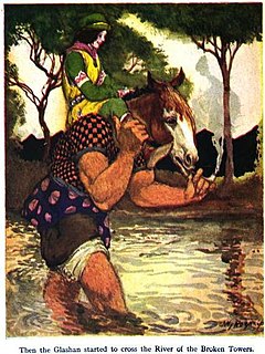
Glashtyn is a legendary creature from Manx folklore.
"The Merry Men" is a short story by Robert Louis Stevenson first published in 1882 in Cornhill Magazine 45-6. The story was later published in Stevenson's collection The Merry Men and Other Tales and Fables (1887). It is set on the fictional island Eilean Aros, based on the Isle of Erraid. The title derives from the local name given to a group of waves in the story, not from the Merry Men of Robin Hood and his merry men
Douglas Southern Electric Tramway was a standard gauge tramway between the top of Douglas Head on the Isle of Man and the nearby resort of Port Soderick. The route ran atop the cliffs and crossed a number of viaducts and bridges.
Douglas Head Amphitheatre is a structure on the promontory of Douglas Head on the Isle of Man.
Cape Three Forks or Cape Tres Forcas is a headland on the Mediterranean coast of northeastern Morocco.
Stoneykirk is an area and a village in the heart of the Rhins of Galloway, Wigtownshire, in the administrative council area of Dumfries and Galloway, Scotland nearly ten miles in length and three and a half miles in breadth, bounded on the east by the bay of Luce, and on the west by the Irish Channel, 5 miles (8.0 km) south of Stranraer.
The Bungalow, Isle of Man, one of a handful of better-known vantage points spread around the Snaefell Mountain Course, is situated adjacent to the 31st Milestone roadside marker on the road junction of the primary A18 Mountain Road, the A14 Sulby Glen Road and the road-tramway crossing for the Snaefell Mountain Railway in the parish of Lezayre in the Isle of Man.
Far End Halt is a stopping place on the Manx Electric Railway on the Isle of Man and is located on the climb towards the line's first summit.
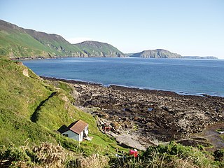
Niarbyl, meaning "the tail" in Manx for the way it extends into the Irish Sea, is a rocky promontory on the southwest coast of the Isle of Man between Port Erin and Peel. It is best known for its spectacular sea views which include the Calf of Man and, on clear days, the mountains of Ireland.
Robert Pierre André Sténuit is a Belgian journalist, writer, and underwater archeologist. In 1962 he spent 24 hours on the floor of the Mediterranean Sea in the submersible "Link Cylinder" developed by Edwin Link, thus becoming the world's first aquanaut.
The Manx Aviation and Military Museum is a museum dedicated to the history of aviation and the military on the Isle of Man. The museum is open at the weekends throughout the year and every day from late May to the end of September. Visits at other times and guided tours can be arranged by appointment. Entry to the museum is free. The Museum was opened on Remembrance Day 2000.
This page is based on this Wikipedia article Text is available under the CC BY-SA 4.0 license; additional terms may apply. Images, videos and audio are available under their respective licenses.