
The British Virgin Islands (BVI), officially the Virgin Islands, are a British Overseas Territory in the Caribbean, to the east of Puerto Rico and the US Virgin Islands and north-west of Anguilla. The islands are geographically part of the Virgin Islands archipelago and are located in the Leeward Islands of the Lesser Antilles and part of the West Indies.

The British Virgin Islands (BVI) are one of three political divisions of the Virgin Islands archipelago located in the Lesser Antilles, between the Caribbean Sea and the North Atlantic Ocean. The BVI are the easternmost part of the island chain. The land area totals and comprises 16 inhabited and more than 20 uninhabited islands. The islands of Tortola, Anegada, Virgin Gorda and Jost van Dyke are the largest. Maritime claims include 12 nmi territorial sea and a 200 nmi exclusive fishing zone. In terms of land use, it is 20% arable land, 6.67% permanent crops and 73.33% other as of a 2005 figure. It has strong ties to nearby U.S. Virgin Islands and Puerto Rico.

The History of the British Virgin Islands is usually, for convenience, broken up into five separate periods:

Punta Gorda, declared a town on Monday, 21 January 1895, known locally as P.G., is the capital and largest town of Toledo District in southern Belize. Punta Gorda is the southernmost sizable town in the nation, with a population of about 5,000 people. Although the town bears a Spanish name, its inhabitants are mostly Kriol/English-speaking and are primarily of Garifuna, East Indian, Kriol, and Maya descent.
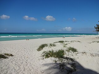
Varadero, also referred to as Playa Azul, is a resort town in the province of Matanzas, Cuba, and one of the largest resort areas in the Caribbean. Varadero Beach is rated one of the world's best beaches in TripAdvisor's Traveler's Choice Awards since 2019, ranking at number 9 as of January 2024. Common activities include fishing and excursions to Matanzas, Cárdenas, and the Península de Zapata.

Burnham-on-Crouch is a town and civil parish in the Maldon District of Essex, in the East of England; it lies on the north bank of the River Crouch. It is one of Britain's leading places for yachting.

Virgin Gorda is the third-largest island and second-most populous of the British Virgin Islands (BVI).

Roatán is an island in the Caribbean, about 65 kilometres (40 mi) off the northern coast of Honduras. The largest of the Bay Islands of Honduras, it is located between the islands of Utila and Guanaja. The island was formerly known in English as Ruatan and Rattan.

The Abaco Islands lie in the northern Bahamas, about 193 miles east of Miami, Florida. The main islands are Great Abaco and Little Abaco, which is just west of Great Abaco's northern tip. There are several smaller barrier cays, of which the northernmost are Walker's Cay and its sister island Grand Cay. To the south, the next inhabited islands are Spanish Cay and Green Turtle Cay, with its settlement of New Plymouth, Great Guana Cay, private Scotland Cay, Man-O-War Cay, and Elbow Cay, with its settlement of Hope Town. Southernmost are Tilloo Cay and Lubbers Quarters. Also of note off Abaco's western shore is Gorda Cay, now a Disney-owned island and cruise ship stop renamed Castaway Cay. Also in the vicinity is Moore's Island. On the Big Island of Abaco is Marsh Harbour, the Abacos' commercial hub and the Bahamas' third-largest city, plus the resort area of Treasure Cay. Both have airports. A few mainland settlements of significance are Coopers Town and Fox Town in the north and Cherokee and Sandy Point in the south. Administratively, the Abaco Islands constitute seven of the 31 Local Government Districts of the Bahamas: Grand Cay, North Abaco, Green Turtle Cay, Central Abaco, South Abaco, Moore's Island, and Hope Town.

Road Town, located on Tortola, is the capital and largest town of the British Virgin Islands. It is situated on the horseshoe-shaped Road Harbour in the centre of the island's south coast. The population was about 15,000 in 2018.
Fisherman's Village is a waterfront mall, commercial boat anchorage and tourist attraction located in the world's largest man-made small boat harbor in Los Angeles County at Marina del Rey, California. The Ballona Wetlands State Ecological Reserve is just east of Fisherman's Village and immediately to the south is the federally-owned riverine estuary of Ballona Creek. The historical Fisherman's Village, built in 1967, is nestled on the eastern bank of main harbor entrance channel between Whiskey Reds restaurant to the south and the Windward boatyard to the north.

Joost van Dyk was a Dutch privateer who was one of the earliest European settlers in the British Virgin Islands in the seventeenth century, and established the first permanent settlements within the Territory. The islands of Jost Van Dyke and its smaller neighbor Little Jost Van Dyke, as well as Little Dix Bay on Virgin Gorda island, are named after him.

The Copper Mine on Virgin Gorda, British Virgin Islands, is a national park containing the ruins of an abandoned 19th-century copper mine.
The BVIFA National Football League is the highest competitive football league in the British Virgin Islands. The league was founded in 2009 after the merger between the Tortola League and the Virgin Gorda League.

Eustatia Island is a 30-acre island of the British Virgin Islands (BVI) in the Caribbean. The word "Eustatia" is a Greek derived word meaning, "good place to stay." The entire island, and a small neighboring island, Saba Rock, are under the same long term lease. The island is regularly featured and photographed for several publications and was listed as one of the top 20 most beautiful islands in the world in the December 2004 issue of Islands magazine.

Saba Rock is a small island of the British Virgin Islands in the Caribbean, approximately an acre and a half in size. The island contains a small hotel, restaurant, bar, and gift shop. A dock is available for day visitors and a large mooring field accommodates yachts staying overnight. The resort operates a boat shuttle from Saba Rock to Bitter End Yacht Club and Leverick Bay Marina.

Sage Mountain National Park is a protected area of the British Virgin Islands. It is named after the highest peak of the island of Tortola, Mount Sage. The Mount Sage volcanic peak rises to a height of 1,716 feet (523 m), and is thus the highest point in all of the Virgin Islands. The park is located to the southwest of the island group's capital, Road Town. The park, which includes the mountain range, extends over an area of 96 acres (39 ha). The vegetation is of semi-rain forest type. There are many trails for trekking and hiking.
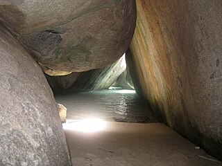
The Baths is a beach area on the island of Virgin Gorda among the British Virgin Islands in the Caribbean.

The Dutch Virgin Islands is the collective name for the enclaves that the Dutch West India Company had in the Virgin Islands. The area was ruled by a director, whose seat was not permanent. The main reason for starting a colony here was that it lay strategically between the Dutch colonies in the south and New Netherland. The Dutch West India Company was mainly affected by the competition from Denmark, England and Spain. In 1680 the remaining islands became a British colony.
