The Baths

Last updated
The Baths National Park
TheBaths VirginGorda BVI.jpg
One of many baths found among scattered granite boulders
British Virgin Islands location map.svg
Red pog.svg
Location of The Baths in Virgin Islands
TypeNatural Area
Location Virgin Gorda, British Virgin Islands
Coordinates 18°25′46″N64°26′43″W / 18.42937°N 64.445398°W / 18.42937; -64.445398 Coordinates: 18°25′46″N64°26′43″W / 18.42937°N 64.445398°W / 18.42937; -64.445398

The Baths is a beach area on the island of Virgin Gorda among the British Virgin Islands in the Caribbean.

Contents

Geography

The Baths is situated about 1.2 miles (1.9 km) south off the maintown Spanish Town at the southern tip of the island between Spring Bay and Devil's Bay. The Baths is an area of unique geologic formations and one of the BVI's major tourist destinations.

Area

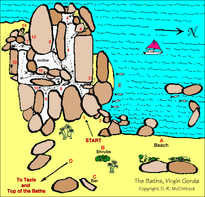
Although volcanism accounts for much of the Virgin Islands, The Baths was formed by granite that eroded into piles of boulders on the beach. [1] Granite forms from the slow cooling of magma at depth nowhere close to surface volcanoes. The granite only appears at the surface after geologic ages have eroded away all the overburden covering it. Once exposed, erosion continued to isolate the granite into large boulders and round their surfaces. The boulders form natural tidal pools, tunnels, arches, and scenic grottoes that are open to the sea. [2] The largest boulders are about 40 feet (12 m) long.

Since 1990, the area has been a BVI National Park [3] as are the adjacent bays, [4] and the area is a major tourist attraction, with swimming and snorkelling being the main attractions.

Notes

  1. Excerpt from The Baths by Julian Putley
  2. "The Baths, Virgin Gorda – Ultimate BVI – British Virgin Islands". Archived from the original on 2008-01-13. Retrieved 2008-01-15.
  3. Welcome to the BVI National Parks Trust – Parks – Virgin Gorda 2
  4. National Parks | British Virgin Islands | Caribbean Destination | BVI

Commons-logo.svg Media related to The Baths (Virgin Gorda) at Wikimedia Commons

Related Research Articles

British Virgin Islands British Overseas Territory in the Caribbean

The British Virgin Islands, officially the Virgin Islands, are a British Overseas Territory in the Caribbean, to the east of Puerto Rico and the U.S. Virgin Islands and north-west of Anguilla. The islands are geographically part of the Virgin Islands archipelago and are located in the Leeward Islands of the Lesser Antilles and part of the West Indies.

Boulder Natural rock fragment larger than 25.6 centimetres in diameter

In geology, a boulder is a rock fragment with size greater than 256 millimetres (10.1 in) in diameter. Smaller pieces are called cobbles and pebbles. While a boulder may be small enough to move or roll manually, others are extremely massive. In common usage, a boulder is too large for a person to move. Smaller boulders are usually just called rocks or stones. The word boulder is short for boulder stone, from Middle English bulderston or Swedish bullersten.

Karlu Karlu / Devils Marbles Conservation Reserve Protected area in the Northern Territory, Australia

Karlu Karlu / Devils Marbles Conservation Reserve is a protected area in the Northern Territory of Australia located in the locality of Warumungu about 105 km (65 mi) south of Tennant Creek, and 393 km (244 mi) north of Alice Springs. The nearest settlement is the small town of Wauchope located 9 km (5.6 mi) to the south.

Alum Bay

Alum Bay is a bay near the westernmost point of the Isle of Wight, England, within close sight of the Needles rock formation. Of geological interest and a tourist attraction, the bay is noted for its multi-coloured sand cliffs. The waters and adjoining seabed form part of the Needles Marine Conservation Zone and the shore and heath above are part of the Headon Warren and West High Down Site of Special Scientific Interest.

Virgin Gorda Island which is part of the British Virgin Islands

Virgin Gorda is the third-largest and second-most populous of the British Virgin Islands (BVI).

Virgin Islands National Park 14,700 acres in St. John, Virgin Islands (US) managed by the National Park Service

The Virgin Islands National Park is an American national park preserving about 60% of the land area of Saint John in the United States Virgin Islands, as well as more than 5,500 acres of adjacent ocean, and nearly all of Hassel Island, just off the Charlotte Amalie, Saint Thomas harbor.

Anegada Northernmost of the British Virgin Islands

Anegada is the northernmost of the British Virgin Islands (BVI), a group of islands that form part of the archipelago of the Virgin Islands. It lies approximately 15 miles (24 km) north of Virgin Gorda. Anegada is the only inhabited British Virgin Island formed from coral and limestone, rather than being of volcanic origin. While the other islands are mountainous, Anegada is flat and low. Its highest point is only about 28 feet (8.5 m) above sea level, earning it its name, which is the Spanish term for the flooded land, "tierra anegada".

Tortola Largest of the British Virgin Islands

Tortola is the largest and most populated of the British Virgin Islands, a group of islands that form part of the archipelago of the Virgin Islands. It has a surface area of 55.7 square kilometres with a total population of 23,908, with 9,400 residents in Road Town. Mount Sage is its highest point at 530 metres above sea level.

Jost Van Dyke Smallest of the four main islands of the British Virgin Islands

Jost Van Dyke is the smallest of the four main islands of the British Virgin Islands, measuring roughly 8 square kilometres. It rests in the northern portion of the archipelago of the Virgin Islands, located in the Atlantic Ocean and Caribbean Sea. Jost Van Dyke lies about 8 km (5 mi) to the northwest of Tortola and 8 km (5 mi) to the north of Saint John. Little Jost Van Dyke lies off its eastern end.

Cruz Bay, U.S. Virgin Islands

Cruz Bay, U.S. Virgin Islands is the main town on the island of Saint John in the United States Virgin Islands. According to the 2000 census, Cruz Bay had a population of 2,743.

Boulders Beach Beach in Cape Town, South Africa

Boulders Beach is a sheltered beach made up of inlets between granite boulders, from which the name originated. It is located on the Cape Peninsula, in Simon's Town, a suburb of Cape Town in the Western Cape province of South Africa. It is also commonly known as Boulders Bay. It is a popular tourist spot because of a colony of African penguins which settled there in 1982. Boulders Beach forms part of the Table Mountain National Park.

Spanish Town on southern Virgin Gorda is the second largest town on the British Virgin Islands. Also known as The Valley, Spanish Town offers numerous shopping possibilities. The heart of the town is its Yacht Harbor marina, with many bareboat sailing activities every day. It has its own airport and a ferry service is in operation from here to Road Town on Tortola. Overall, though, Spanish Town is small, with few bars and a relaxed atmosphere. The national park "The Baths" is located south of Spanish Town.

Eustatia Island

Eustatia Island is a 30-acre island of the British Virgin Islands (BVI) in the Caribbean. The word "Eustatia” is a Greek derived word meaning, “good place to stay.” The entire island, and a small neighboring island, Saba Rock, are under the same long term lease. The island is regularly featured and photographed for several publications and was listed as one of the top 20 most beautiful islands in the world in the December 2004 issue of Islands magazine.

Dog Islands

Dog Islands are a small group of islets among the British Virgin Islands in the Caribbean.

Tourism in Zimbabwe

Zimbabwe boasts several tourist attractions, located in almost every region of the country. Before the economic changes, much of the tourism for these locations came to the Zimbabwean side but now Zambia benefits from the tourism. The Victoria Falls National Park is also a tourist attraction in this area and is one of the eight main National Parks in Zimbabwe, largest of which is Hwange National Park.

Outline of the British Virgin Islands Overview of and topical guide to the British Virgin Islands

The following outline is provided as an overview of and topical guide to the British Virgin Islands:

Geology of Cape Town Geological formations and their history in the vicinity of Cape Town

Cape Town lies at the south-western corner of the continent of Africa. It is bounded to the south and west by the Atlantic Ocean, and to the north and east by various other municipalities in the Western Cape province of South Africa.

Bideford Bay

Bideford Bay, also known as Barnstaple Bay and often shown on maps as Barnstaple or Bideford Bay, is a large area of water on the northwest coast of Devon in South West England, at the southwestern end of the Bristol Channel where it joins the Celtic Sea. The bay extends from Hartland Point in the southwest to Baggy point the northeast, and is partly sheltered by the island of Lundy, 12 miles (19 km) offshore. It takes its alternative names from the towns of Bideford and Barnstaple, located respectively on the rivers Torridge and Taw which flow into the bay. The alternative spelling Barnstable Bay, in use long after that spelling became obsolete for the town, is also sometimes seen.

East End, Saint Thomas, U.S. Virgin Islands Subdistrict

East End is an administrative subdistrict of the island of Saint Thomas in the United States Virgin Islands. The largest community here is Red Hook, while smaller communities include Benner, Nazareth, Nadir, Frydendal, and Smith Bay. Some of the offshore islands here include Great Saint James Island, Little Saint James Island, Bovoni Cay, Patricia Cay, Cas Cay, Rotto Cay, Thatch Cay, Shark Island, and Dog Island. The East End subdistrict received 731 new residents between the 2000 U.S. Census and the 2010 U.S. Census, and has a 2010 population of 6,658. The East End region offers a more secluded character and less population density than subdistricts as Charlotte Amalie, Southside, and the Tutu subdistricts. This subdistrict is home to numerous of the islands’ largest resorts, in addition to many shopping areas and entertainment venues, as well as the Coral World Marine Park & Underwater Observatory in Coki Point, which is the most popular tourist attraction on Saint Thomas. East End is located about 7.4 miles east of the territorial capital of Charlotte Amalie, which is an approximately thirty-minute drive on the windy, small and narrow Saint Thomas roads. There are buses and taxis leaving from the East End. A typical fare for a taxi drive to the capital costs $20. The hotels on Saint Thomas are evenly divided between the two subdistricts of Charlotte Amalie, and the more expensive resort-style hotels by their own beachside in East End. The East End resorts are therefore generally more expensive than those found elsewhere on the island. Some of the famous beaches found here are Lindquist- and Sapphire Beaches, while others include Pineapple Beach and Vessup Beach amongst others.