Related Research Articles
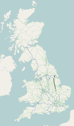
The A1, also known as the Great North Road, is the longest numbered road in the United Kingdom, at 410 miles (660 km). It connects London, the capital of England, with Edinburgh, the capital of Scotland. The numbering system for A-roads, devised in the early 1920s, was based around patterns of roads radiating from two hubs at London and Edinburgh. The first number in the system, A1, was given to the most important part of that system: the road from London to Edinburgh, joining the two central points of the system and linking the UK's (then) two mainland capital cities. It passes through or near north London, Hatfield, Welwyn Garden City, Stevenage, Baldock, Letchworth Garden City, Biggleswade, Eaton Socon, Buckden, Peterborough, Stamford, Grantham, Newark-on-Trent, Retford, Doncaster, Pontefract, York, Wetherby, Ripon, Darlington, Durham, Gateshead, Newcastle upon Tyne, Morpeth, Alnwick and Berwick-upon-Tweed.

The A14 is a major trunk road in England, running 127 miles (204 km) from Catthorpe Interchange, a major intersection at the southern end of the M6 and junction 19 of the M1 in Leicestershire to the Port of Felixstowe, Suffolk. The road forms part of the unsigned Euroroutes E24 and E30. It is the busiest shipping lane in East Anglia carrying anything from cars to large amounts of cargo between the UK and Mainland Europe.

The A12 is a major road in Eastern England. It runs north-east/south-west between London and the coastal town of Lowestoft in the north-eastern corner of Suffolk, following a similar route to the Great Eastern Main Line until Ipswich. A section of the road between Lowestoft and Great Yarmouth became part of the A47 in 2017. Between the junctions with the M25 and the A14, the A12 forms part of the unsigned Euroroute E30. Unlike most A roads, this section of the A12, together with the A14 and the A55, has junction numbers as if it were a motorway.
The A15 is a major road in England. It runs north from Peterborough via Market Deeping, Bourne, Sleaford and Lincoln along a variety of ancient, Roman, and Turnpike alignments before it is interrupted at its junction with the M180 near Scawby. The road restarts 10 miles (16 km) east, and then continues north past Barton-upon-Humber, crossing the Humber on the Humber Bridge before terminating at Hessle near Kingston upon Hull.
The A45 is a major road in England. It runs east from Birmingham past the National Exhibition Centre and the M42, then bypasses Coventry and Rugby, where it briefly merges with the M45 until it continues to Daventry. It then heads to Northampton and Wellingborough before running north of Rushden and Higham Ferrers and terminating at its junction with the A14 in Thrapston.
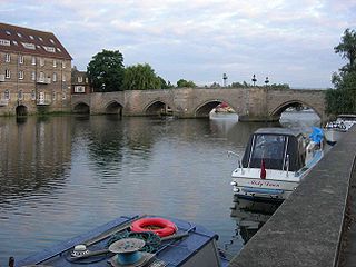
The Old Bridge between Huntingdon and Godmanchester is a well-preserved medieval stone bridge over the River Great Ouse.

The A1198 is a road in Cambridgeshire, England, which runs between the A505 at Royston, and the A1307 on the outskirts of Huntingdon.

The A43 is a primary route in the English Midlands and northern South East England, that runs from the M40 motorway near Ardley in Oxfordshire to Stamford in Lincolnshire. Through Northamptonshire it bypasses the towns of Northampton, Kettering and Corby which are the three principal destinations on the A43 route. The A43 also links to the M1 motorway.
The A428 road is a major road in central and eastern England. It runs between the cities of Coventry and Cambridge by way of the county towns of Northampton and Bedford. Together with the A421,, the eastern section of the A428 forms the route between Cambridge and Oxford. The A428 was formerly part of the main route from Birmingham to Felixstowe before the A14 was fully opened in 1993.

The A505 is a road in the East of England. It follows part of the route of the Icknield Way and the corresponding Icknield Way Path and runs from Leighton Buzzard in Bedfordshire to the A11 Abington Interchange North in Cambridgeshire.
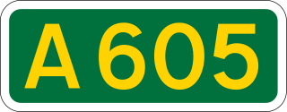
The A605 road is a main road in the English counties of Northamptonshire and Cambridgeshire.
The A1307 is a secondary class A road in Cambridgeshire and Suffolk between the A1(M) near Alconbury and Haverhill, Suffolk. In 2020 the former A14 between North of Cambridge and Alconbury was reclassified as the A1307. Whilst it generally follows the route of the Roman Road Via Devana from Alconbury to Haverhill. As it becomes unroutable through Cambridge, and sections were developed in different decades, it has been delt with in three parts: Cambridge city, Eastern and Northern.
The A607 is an A road in England that starts in Belgrave, Leicester and heads northeastwards through Leicestershire and the town of Grantham, Lincolnshire, terminating at Bracebridge Heath, a village on the outskirts of Lincoln. It is a primary route from Thurmaston to the A1 junction at Grantham.

The Brampton Hut interchange west of Huntingdon links the A1 and A14 trunk roads, and the A141 road which takes traffic into Huntingdon or towards Norfolk.

The A6003 links Kettering and Corby in Northamptonshire, with Oakham in Rutland, via Leicestershire. The road forms the principal link between Rutland and Northamptonshire.

The A448 is a main road in England running between Studley in Warwickshire and Kidderminster in Worcestershire.

The A186 is a road in Tyne and Wear, England. It runs between the A1 Junction 75, and the eastern end of the A69 to the A192 in Whitley Bay. It follows the old A69 into Newcastle-upon-Tyne city centre.

Victoria Road is a residential road in the north of Cambridge, England. The road is designated the A1134. At the western end, the road links with Histon Road, Huntingdon Road, Mount Pleasant, and Castle Street.In 1950, there were plans to improve this junction, but they never came to fruition. At the eastern end it links with Chesterton Road (A1303) and also links to Milton Road, the A1134, then A1309, northeast out of the city, also linking with the A14.

Histon Road is an arterial road linking central Cambridge, England with the A14 road north of the city. The road is designated the B1049. At the southern end, the road links with Huntingdon Road (A1307), Victoria Road (A1134), Mount Pleasant, and Castle Street. At the northern end of the road it continues just south of the A14 as Cambridge road into the village of Impington.
References
- ↑ Traffic lights have now been removed from the western arm as the A14 has been diverted to the south. The roundabout now sits on the A141 and links to Cambridgeshire Constabulary. Government News Network. "66 per cent fewer incidents after new traffic lights installed on the A14 Spittals Interchange, Huntingdon".
- ↑ "History of Almshouses". The Almshouse Association.
- ↑ A History of the County of Huntingdon: Volume 2. Victoria County History. 1932.
- ↑ Ordnance Survey County Series: Huntingdonshire. 1892