Spodnje Jezersko

Last updated
Spodnje Jezersko
Spodnje Jezersko Slovenia 2.jpg
Slovenia location map.svg
Red pog.svg
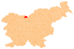
Spodnje Jezersko
Location in Slovenia
Coordinates: 46°22′54.81″N14°28′7.28″E / 46.3818917°N 14.4686889°E / 46.3818917; 14.4686889 Coordinates: 46°22′54.81″N14°28′7.28″E / 46.3818917°N 14.4686889°E / 46.3818917; 14.4686889
Country Flag of Slovenia.svg Slovenia
Traditional region Carinthia
Statistical region Upper Carniola
Municipality Jezersko
Area
  Total 27.84 km2 (10.75 sq mi)
Elevation 715.2 m (2,346.5 ft)
Population (2002)
  Total 80
[1]

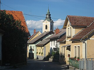
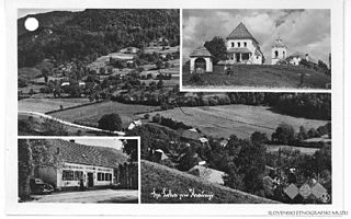
Spodnje Jezersko (pronounced  [ˈspoːdnjɛ jɛˈzɛːɾskɔ]  ( Loudspeaker.svg   listen ); literally, 'Lower Jezersko') is a settlement in the Municipality of Jezersko in Slovenia. It is part of the traditional region of Carinthia and the Upper Carniola Statistical Region.

Municipality of Jezersko Municipality in Slovenia

The Municipality of Jezersko is a municipality in northern Slovenia. In 1995, Jezersko became part of Preddvor and became an independent municipality in 1998. Originally located in the historic region of Carinthia, it became part of the Upper Carniola Statistical Region in 2005.

Slovenia republic in Central Europe

Slovenia, officially the Republic of Slovenia, is a sovereign state located in southern Central Europe at a crossroads of important European cultural and trade routes. It is bordered by Italy to the west, Austria to the north, Hungary to the northeast, Croatia to the southeast, and the Adriatic Sea to the southwest. It covers 20,273 square kilometers (7,827 sq mi) and has a population of 2.07 million. One of the successor states of the former Yugoslavia, Slovenia is a parliamentary republic and a member of the United Nations, of the European Union, and of NATO. The capital and largest city is Ljubljana.

Upper Carniola Statistical Region Statistical region in 18

The Upper Carniola Statistical Region is a statistical region in northwest Slovenia. It is a region with high mountains, including Mount Triglav, and is almost entirely Alpine. A large part of this statistical region is protected as a national park. The relief and climate are good bases for tourism. In 2013, the region recorded almost 19% of tourist nights in Slovenia, of which 78% were by foreign tourists. The region ranked second in Slovenia in number of tourist beds per 1,000 population, even though it had just over half as many beds as the Coastal–Karst Statistical Region. In 2013, the registered unemployment rate here was the lowest in Slovenia, 3 percentage points lower than the national average and more than 8 percentage points lower than in the Mura Statistical Region, where the registered unemployment rate was the highest. Although agriculture in this region is not among the most important activities, the farms are among the largest in the country both in terms of average utilised agricultural area per farm and in terms of the number of livestock per farm.

Contents

Geology

On the left bank of the Kokra River, about 2 km south of the settlement, thick layers of travertine are occasionally still mined, particularly for restoration of listed buildings in Upper Carniola, where it was traditionally used as a building material. [2]

Kokra river in Slovenia

The Kokra is a river of Slovenia. Originating in the Karawanks, the river is 34 km (21 mi) long. It flows into the Sava in Kranj.

Travertine A form of limestone deposited by mineral springs

Travertine is a form of limestone deposited by mineral springs, especially hot springs. Travertine often has a fibrous or concentric appearance and exists in white, tan, cream-colored, and even rusty varieties. It is formed by a process of rapid precipitation of calcium carbonate, often at the mouth of a hot spring or in a limestone cave. In the latter, it can form stalactites, stalagmites, and other speleothems. It is frequently used in Italy and elsewhere as a building material.

Chapel

Saint Hubertus's Chapel Spodnje Jezersko Slovenia - chapel.jpg
Saint Hubertus's Chapel

A masonry chapel dedicated to Saint Hubertus stands on a hill in the southern part of the settlement, in the hamlet of Zgornje Fužine. It is a single-nave structure with a belfry that was built in the Gothic Revival style in 1853. The chapel contains wooden furnishings and an oil painting of Saint Hubertus. [3]

Hubertus Christian saint, first bishop of Liège

Saint Hubertus or Hubert became Bishop of Liège in 708 AD. He is a Christian saint who is the patron saint of hunters, mathematicians, opticians, and metalworkers. Known as the Apostle of the Ardennes, he was called upon, until the early 20th century, to cure rabies through the use of the traditional St Hubert's Key.

Gothic Revival architecture architectural movement

Gothic Revival is an architectural movement popular in the Western World that began in the late 1740s in England. Its popularity grew rapidly in the early 19th century, when increasingly serious and learned admirers of neo-Gothic styles sought to revive medieval Gothic architecture, in contrast to the neoclassical styles prevalent at the time. Gothic Revival draws features from the original Gothic style, including decorative patterns, finials, lancet windows, hood moulds and label stops.

Related Research Articles

Semič Settlement in Lower Carniola, Slovenia

Semič is a settlement in southeastern Slovenia. It is the administrative centre of the Municipality of Semič.

Črnuče District District in Upper Carniola, Slovenia

The Črnuče District, or simply Črnuče, is a district of the City Municipality of Ljubljana in the northern part of Ljubljana, the capital of Slovenia. It is named after the former town of Črnuče.

Spodnje Duplje Place in Upper Carniola, Slovenia

Spodnje Duplje is a settlement in the Municipality of Naklo in the Upper Carniola region of Slovenia.

Spodnje Palovče Place in Upper Carniola, Slovenia

Spodnje Palovče is a settlement in the hills east of Kamnik in the Upper Carniola region of Slovenia.

Spodnje Stranje in Upper Carniola, Slovenia

Spodnje Stranje is a settlement on the right bank of the Kamnik Bistrica River in the Municipality of Kamnik in the Upper Carniola region of Slovenia.

Zgornje Jezersko Place in Carinthia, Slovenia

Zgornje Jezersko is a settlement and administrative centre of the Municipality of Jezersko in northern Slovenia. It is part of the traditional Slovenian Carinthia region and the Upper Carniola Statistical Region.

Spodnje Prapreče in Upper Carniola, Slovenia

Spodnje Prapreče is a village near Lukovica in the eastern part of the Upper Carniola region of Slovenia.

Spodnje Loke in Upper Carniola, Slovenia

Spodnje Loke is a settlement east of Krašnja on the main road from Ljubljana to Celje in the eastern part of the Upper Carniola region of Slovenia. It is in the municipality of Lukovica.

Spodnje Koseze in Upper Carniola, Slovenia

Spodnje Koseze is a village south of Lukovica pri Domžalah in the eastern part of the Upper Carniola region of Slovenia.

Krapje, Ljutomer in Styria, Slovenia

Krapje is a settlement on the right bank of the Mura River in the Municipality of Ljutomer in northeastern Slovenia. It is divided into two distinct hamlets, Zgornje Krapje and Spodnje Krapje. The area traditionally belonged to the Styria region and is now included in the Mura Statistical Region.

Spodnje Dule in Lower Carniola, Slovenia

Spodnje Dule is a settlement in the hills northwest of Leskovec pri Krškem in the Municipality of Krško in eastern Slovenia. The area was traditionally part of Lower Carniola and is now included with the rest of the municipality in the Lower Sava Statistical Region.

Spodnje Pijavško in Lower Carniola, Slovenia

Spodnje Pijavško is a settlement on the right bank of the Sava River in the Municipality of Krško in eastern Slovenia. The area was traditionally part of Lower Carniola and is now included with the rest of the municipality in the Lower Sava Statistical Region.

Zilje in White Carniola, Slovenia

Zilje is a settlement above the left bank of the Kolpa River in the Municipality of Črnomelj in the White Carniola area of southeastern Slovenia. The area is part of the traditional region of Lower Carniola and is now included in the Southeast Slovenia Statistical Region.

Spodnje Gameljne in Upper Carniola, Slovenia

Spodnje Gameljne is a village on the right bank of the Sava River north of the capital Ljubljana in central Slovenia. It belongs to the City Municipality of Ljubljana. It was part of the traditional region of Upper Carniola and is now included with the rest of the municipality in the Central Slovenia Statistical Region.

Srednje Gameljne in Upper Carniola, Slovenia

Srednje Gameljne lies north of the capital Ljubljana in central Slovenia. It belongs to the City Municipality of Ljubljana. It was part of the traditional region of Upper Carniola and is now included with the rest of the municipality in the Central Slovenia Statistical Region.

Spodnje Jelenje in Lower Carniola, Slovenia

Spodnje Jelenje is a small settlement northwest of Dole pri Litiji in the Municipality of Litija in central Slovenia. The area was traditionally part of Lower Carniola and is now included with the rest of the municipality in the Central Sava Statistical Region.

Čolnišče Place in Upper Carniola, Slovenia

Čolnišče is a settlement west of Zagorje ob Savi in central Slovenia. The area is part of the traditional region of Upper Carniola. It is now included with the rest of the municipality in the Central Sava Statistical Region.

Kolovrat, Zagorje ob Savi in Upper Carniola, Slovenia

Kolovrat is a settlement in the Municipality of Zagorje ob Savi in central Slovenia. The area is part of the traditional region of Upper Carniola. It is now included with the rest of the municipality in the Central Sava Statistical Region. The settlement includes the hamlets of Kal, Plavišnik, Prevalje, Spodnje Vrtače, Senčna Vas, and Strma Njiva.

Spodnje Vodale Place in Lower Carniola, Slovenia

Spodnje Vodale is a settlement east of Tržišče in the Municipality of Sevnica in east-central Slovenia. The municipality is now included in the Lower Sava Statistical Region. The area was traditionally part Lower Carniola.

References