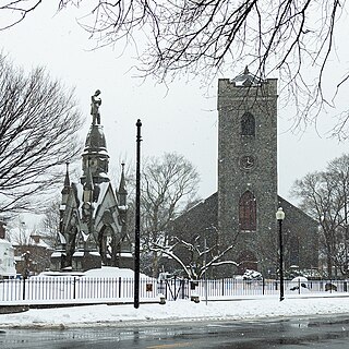
Jamaica Plain is a neighborhood of 4.4 square miles (11 km2) in Boston, Massachusetts, United States. Settled by Puritans seeking farmland to the south, it was originally part of Roxbury. The community seceded from Roxbury during the formation of West Roxbury in 1851 and became part of Boston when West Roxbury was annexed in 1874. In the 19th century, Jamaica Plain became one of the first streetcar suburbs in America and home to a significant portion of Boston's Emerald Necklace of parks, designed by Frederick Law Olmsted.

Roslindale is a primarily residential neighborhood of Boston, Massachusetts, United States, bordered by Jamaica Plain, Hyde Park, West Roxbury and Mattapan. It is served by an MBTA Commuter Rail line, several MBTA bus lines and the MBTA Orange Line in nearby Jamaica Plain. Roslindale has its own branch of the Boston Public Library, the neighborhood is covered by Boston Police District E-5 in West Roxbury, Boston EMS Ambulance 17 is stationed in Roslindale, and the Boston Fire Department has a station on Canterbury Street which houses Ladder 16, Engine 53 & District Chief 12. Roslindale's original Engine Company 45, was deactivated on April 10, 1981, due to budget cuts. Roslindale was once called the "garden suburb" of Boston. The portion of the Arnold Arboretum south of Bussey Street is located in Roslindale.
The Southwest Corridor or Southwest Expressway was a project designed to bring an eight-lane highway into the City of Boston from a direction southwesterly of downtown. It was supposed to connect with Interstate 95 (I-95) at Route 128. As originally designed, it would have followed the right of way of the former Penn Central/New Haven Railroad mainline running from Readville, north through Roslindale, Forest Hills and Jamaica Plain, where it would have met the also-cancelled I-695. The 50-foot-wide median for the uncompleted "Southwest Expressway" would have carried the southwest stretch of the MBTA Orange Line within it, replacing the Washington Street Elevated railway's 1901/1909-built elevated railbed. Another highway, the four-lane South End Bypass, was proposed to run along the railroad corridor between I-695 in Roxbury and I-90 near Back Bay.

The Emerald Necklace consists of a 1,100-acre chain of parks linked by parkways and waterways in Boston and Brookline, Massachusetts. It was designed by landscape architect Frederick Law Olmsted, and gets its name from the way the planned chain appears to hang from the "neck" of the Boston peninsula. In 1989, the Emerald Necklace was designated as a Boston Landmark by the Boston Landmarks Commission.

Forest Hills station is an intermodal transfer station in Boston, Massachusetts. It serves the MBTA rapid transit Orange Line and three MBTA Commuter Rail lines and is a major terminus for MBTA bus routes. It is located in Forest Hills, in the southern part of the Jamaica Plain neighborhood. Most Providence/Stoughton Line and Franklin/Foxboro Line trains, and all Amtrak Northeast Corridor trains, pass through the station without stopping. Forest Hills station is fully accessible on all modes.

The Rose Fitzgerald Kennedy Greenway is a linear park located in several Downtown Boston neighborhoods. It consists of landscaped gardens, promenades, plazas, fountains, art, and specialty lighting systems that stretch over one mile through Chinatown, the Financial District, the Waterfront, and North End neighborhoods. Officially opened in October 2008, the 17-acre Greenway sits on land created from demolition of the John F. Fitzgerald Expressway as part of the Big Dig project.

The E branch is a light rail line in Boston, Cambridge, Medford, and Somerville, Massachusetts, operating as part of the Massachusetts Bay Transportation Authority (MBTA) Green Line. The line runs in mixed traffic on South Huntington Avenue and Huntington Avenue between Heath Street and Brigham Circle, in the median of Huntington Avenue to Northeastern University, then into the Huntington Avenue subway. The line merges into the Boylston Street subway just west of Copley, running to North Station via the Tremont Street subway. It then follows the Lechmere Viaduct to Lechmere, then the Medford Branch to Medford/Tufts. As of February 2023, service operates on eight-minute headways at weekday peak hours and eight to nine-minute headways at other times, using 13 to 17 trains.

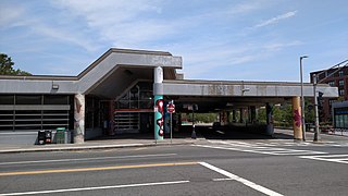
Green Street station is a rapid transit station in Boston, Massachusetts. It serves the MBTA's Orange Line and is located in the southern part of the Jamaica Plain neighborhood. Green Street is the least-used station on the Orange Line, averaging 3,055 weekday boardings in FY 2019. Like all Orange Line stations, it is fully accessible.

Jamaica Pond is a kettle lake, part of the Emerald Necklace of parks in Boston designed by Frederick Law Olmsted. The pond and park are in the Jamaica Plain neighborhood of Boston, close to the border of Brookline. It is the source of the Muddy River, which drains into the lower Charles River.USGS 2005

The Charles River Esplanade of Boston, Massachusetts, is a state-owned park situated in the Back Bay area of the city, on the south bank of the Charles River Basin.

Roxbury Crossing station is a rapid transit station in Boston, Massachusetts. It serves the MBTA Orange Line, and is located on Tremont Street in the Mission Hill neighborhood. The current station opened in 1987 as part of the renovation and relocation of the southern Orange Line. Like all stations on the Orange Line, Roxbury Crossing is accessible.

Jamaicaway is a four-lane, undivided parkway in the Jamaica Plain neighborhood of Boston, Massachusetts, United States, near the border of Brookline.
Pinebank Mansion was a Queen Anne style house sited on a hill overlooking Jamaica Pond in Boston, Massachusetts. Built in 1868 by John Hubbard Sturgis, it was the only mansion retained by Frederick Law Olmsted in his plans for the Emerald Necklace park system. It was the only original structure remaining in the park system at the time of its demolition in 2007.
Jackson Square station is a Massachusetts Bay Transportation Authority (MBTA) Orange Line rapid transit station located on Centre Street near Columbus Avenue in the Jamaica Plain neighborhood of Boston, Massachusetts. The station opened in 1987 as part of the Southwest Corridor project. It is served by MBTA bus routes 14, 22, 29, 41, and 44, which operate into an off-street busway located adjacent to the station.

Stony Brook station is a rapid transit station in Boston, Massachusetts. It serves the MBTA Orange Line and is located below grade at Boylston Street in the Jamaica Plain neighborhood. The station opened on May 4, 1987, as part of the Southwest Corridor project, replacing an earlier station that was open from 1897 to 1940.

The Dorchesterway was a parkway planned by 19th century landscape designer Frederick Law Olmsted to be a continuation of the Emerald Necklace park network in Boston, Massachusetts. This plan, however, was never implemented.
Bad Girrls Studios was a popular Boston gallery and performance space from 1994 to 2006 initially located at 59 Amory Street and later moved to 209 Green Street in Jamaica Plain. Founded by School of the Museum of Fine Arts student Jessica Brand, the artist-run studio hosted numerous artistic and community events. Bad Girrls Studios operated under the slogan "Art is Not A Luxury."

Southwest Corridor Park is a linear urban park in Boston, Massachusetts, part of the Metropolitan Park System of Greater Boston and managed by the Massachusetts Department of Conservation and Recreation (DCR). It extends from the South End and Back Bay neighborhoods south for almost five miles (8 km), ending in the Forest Hills section of Jamaica Plain in what was originally planned to be the alignment for Interstate 95 to Boston. It closely follows the routes of regional Amtrak and Commuter Rail lines and the Massachusetts Bay Transportation Authority (MBTA) Orange Line rapid transit rail line, from its Back Bay Station to its terminus at Forest Hills station. It features tennis courts, basketball courts, playgrounds, and walking, jogging, and biking paths.

Don Bosco Technical High School was an all-boys Roman Catholic secondary school for grades 9 through 12 in Boston, Massachusetts, United States. It was founded in 1946 as a school for immigrant boys by the Salesians of Don Bosco, a religious order of priests and brothers. It closed in 1998.

Clint Baclawski is a Boston-based artist who works with photography and light, shooting on an analog camera and transforms the prints into light-filled installation pieces.