Thuringia, officially the Free State of Thuringia, is a state of Germany. Located in central Germany, it covers 16,171 square kilometres (6,244 sq mi), being the sixth smallest of the sixteen German States. It has a population of about 2.1 million.

The Leine is a river in Thuringia and Lower Saxony, Germany. It is a left tributary of the Aller and the Weser and it is 281 km (175 mi) long.
Spring River may refer to:

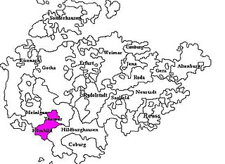
Saxe-Hildburghausen was an Ernestine duchy in the southern side of the present State of Thuringia in Germany. It existed from 1680 to 1826 but its name and borders are currently used by the District of Hildburghausen.

Römhild is a town in the district of Hildburghausen, in Thuringia, Germany. It is situated 14 km west of Hildburghausen, and 21 km southeast of Meiningen. On 31 December 2012, it merged with the former municipalities Gleichamberg, Haina, Mendhausen, Milz and Westenfeld.

Seßlach is a town in the district of Coburg, in northern Bavaria, Germany. It is situated 12 km southwest of Coburg and has a population close to 4,000.
Gleichamberg is a former municipality in the district of Hildburghausen in Thuringia. Since 31 December 2012, it is part of the town Römhild. Gleichamberg consisted of the following subdivisions:
Milz is a village and a former municipality in the district of Hildburghausen, in Thuringia, Germany. Since 31 December 2012, it is part of the town Römhild.
Gleichberge was a Verwaltungsgemeinschaft in the district of Hildburghausen, in Thuringia, Germany. It was disbanded on 31 December 2012. The seat of the Verwaltungsgemeinschaft was in Römhild.

Saxe-Römhild was an Ernestine duchy in the southern foothills of the Thuringian Forest. It existed for only 30 years, from 1680 to 1710.

Milz is a river of Bavaria and of Thuringia, Germany. It flows into the Franconian Saale in Saal an der Saale.

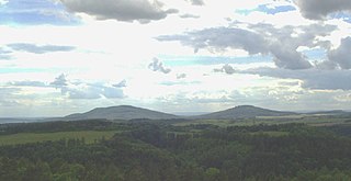
The Gleichberge, which mainly comprise the Großer and Kleiner Gleichberg, are a small, inselberg-like mountain range, up to 679 m above sea level (NHN), in the southwestern part of the German state of Thuringia. They rise just east of the little ancient town of Römhild in the county of Hildburghausen.

Alphonse van Gèle, also written van Gele or Vangele, was a Belgian soldier who served as the Vice-Governor General of the Congo Free State from December 1897 until January 1899. He established the Equator Station, or Station de l’Équateur, today Mbandaka, and concluded a treaty with the powerful Zanzibar trader Tippu Tip at the Stanley Falls station, today Kisangani. He is known for having confirmed that the Uele River was the upper part of the Ubangi River.
Jules Alexandre Milz was a Belgian soldier who was active in exploring the northeast of the Congo Free State. He traveled extensively in Uele District, where he resolved the question of whether the Uele River was the upper portion of the Ubangi River. He was second in command of an expedition to the Nile in 1891–1892, and took over command after the leader died.
The Gada River is a left tributary of the Uele River, which it joins downstream from Niangara in the Haut-Uélé province of the Democratic Republic of the Congo.

Léon Roget was a Belgian soldier and colonial administrator who was active in the Congo Free State. He was the first commander of the Force Publique, the armed force used to police the colony.

Willem Frans Van Kerckhoven, or Guillaume François van Kerckhoven was a Belgian soldier, explorer, colonial administrator who was active in the service of the International Association of the Congo and the subsequent Congo Free State. He is known for his extended expedition through the Uele River basin and onward towards the Nile, during which he cleared the Arab slave traders from the region and established a Belgian presence. He died in an accident before reaching the Nile.
This page is based on this
Wikipedia article Text is available under the
CC BY-SA 4.0 license; additional terms may apply.
Images, videos and audio are available under their respective licenses.


