
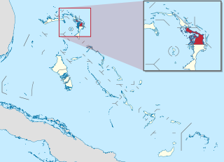
The Bahamas, officially the Commonwealth of The Bahamas, is a country in North America. It is an island country within the Lucayan Archipelago of the West Indies in the Atlantic Ocean. It contains 97% of the Lucayan Archipelago's land area and 88% of its population. The archipelagic state consists of more than 3,000 islands, cays, and islets in the Atlantic Ocean, and is located north of Cuba and northwest of the island of Hispaniola and the Turks and Caicos Islands, southeast of the U.S. state of Florida, and east of the Florida Keys. The capital is Nassau on the island of New Providence. The Royal Bahamas Defence Force describes The Bahamas' territory as encompassing 470,000 km2 (180,000 sq mi) of ocean space.
This article talks about transportation in the Bahamas, a North American archipelagic state in the Atlantic Ocean.

Andros Island is an archipelago within The Bahamas, the largest of the Bahamian Islands. Politically considered a single island, Andros in total has an area greater than all the other 700 Bahamian islands combined. The land area of Andros consists of hundreds of small islets and cays connected by mangrove estuaries and tidal swamplands, together with three major islands: North Andros, Mangrove Cay, and South Andros. The three main islands are separated by bights, estuaries that trifurcate the island from east to west. It is 167 kilometres (104 mi) long by 64 km (40 mi) wide at the widest point.

Local government in The Bahamas exists at two levels: 32 districts and 41 towns. The boundaries of districts are defined by the First Schedule of The Bahamas Local Government Act 1996, defined with reference to parliamentary constituency boundaries. The Second Schedule lists 13 districts which are divided into town areas. Towns are governed by directly elected town committees. Second Schedule districts are governed by nine-person district councils composed of the chairs of the town committees, and if numerically required, additional people elected by the town committees. The 19 Third Schedule districts are unitary authorities which cannot be divided into towns. They are governed by nine-person district councils which are directly elected by voters. The powers of Second Schedule and Third Schedule councils are slightly different, and the Third Schedule district known as the City of Freeport has a slightly different list of enumerated powers.

The Abaco Islands lie in the northern Bahamas, about 193 miles east of Miami, Florida. The main islands are Great Abaco and Little Abaco, which is just west of Great Abaco's northern tip. There are several smaller barrier cays, of which the northernmost are Walker's Cay and its sister island Grand Cay. To the south, the next inhabited islands are Spanish Cay and Green Turtle Cay, with its settlement of New Plymouth, Great Guana Cay, private Scotland Cay, Man-O-War Cay, and Elbow Cay, with its settlement of Hope Town. Southernmost are Tilloo Cay and Lubbers Quarters. Also of note off Abaco's western shore is Gorda Cay, now a Disney-owned island and cruise ship stop renamed Castaway Cay. Also in the vicinity is Moore's Island. On the Big Island of Abaco is Marsh Harbour, the Abacos' commercial hub and the Bahamas' third-largest city, plus the resort area of Treasure Cay. Both have airports. A few mainland settlements of significance are Coopers Town and Fox Town in the north and Cherokee and Sandy Point in the south. Administratively, the Abaco Islands constitute seven of the 31 Local Government Districts of the Bahamas: Grand Cay, North Abaco, Green Turtle Cay, Central Abaco, South Abaco, Moore's Island, and Hope Town.

Grand Bahama is the northernmost of the islands of the Bahamas, with the town of West End located 56 nautical miles east of Palm Beach, Florida. It is the third largest island in the Bahamas island chain of approximately 700 islands and 2,400 cays. The island is roughly 530 square miles (1,400 km2) in area and approximately 153 kilometres (95 mi) long west to east and 24 kilometres (15 mi) at its widest point north to south. Administratively, the island consists of the Freeport Bonded Area and the districts of East Grand Bahama and West Grand Bahama. Nearly half of the homes on the island were damaged or destroyed in early September 2019 by Hurricane Dorian.

Eleuthera refers both to a single island in the archipelagic state of the Commonwealth of the Bahamas and to its associated group of smaller islands. Eleuthera forms a part of the Great Bahama Bank. The island of Eleuthera incorporates the smaller Harbour Island. "Eleuthera" derives from the feminine form of the Greek adjective ἐλεύθερος (eleútheros), meaning "free". Known in the 17th century as Cigateo, it lies 80 km east of Nassau. It is long and thin—180 km long and in places little more than 1.6 km wide. At its narrowest point, the Glass Window Bridge, which has been called the narrowest place on earth, Eleuthera stands 30 feet wide. Its eastern side faces the Atlantic Ocean and its western side faces the Great Bahama Bank. The topography of the island varies from wide rolling pink sand beaches to large outcrops of ancient coral reefs and the highest elevation point is 200 feet. The population is approximately 11,000 and the principal economy of the island is tourism.

Elbow Cay is an five-mile-long (8.0-kilometre) cay in the Abaco Islands of the Bahamas. Originally populated by British loyalists fleeing the newly independent United States of America in 1785, it has survived on fishing, boat building, and salvage. Its main village of Hope Town surrounds a protected harbor with a noted red-and-white-striped one-hundred-and-twenty-foot-tall (37-metre) lighthouse built in 1863. On September 1, 2019, Elbow Cay took a direct hit from Category 5 Hurricane Dorian, with sustained winds of 185 mph (295 km/h). The lighthouse survived.
Coopers Town is a village in Abaco, the second largest island of the Bahamas. It has a population of 676.
Marsh Harbour is a town in Abaco Islands, Bahamas, with a population of 6,283 as of 2012.
Man-O-War Cay is a small island in the Abaco region of the Bahamas. It had a population of 215 at the 2010 census.
Central Abaco is one of the districts of the Bahamas, in the Abaco Islands. The district contains the largest town in the Abacos, Marsh Harbour, which is the commerce centre for the islands. Some of the more noticeable settlements are:

North Abaco is one of the districts of the Bahamas, on the Abaco Islands. It has a population of 9,578 according to the 2010 census.

Great Guana Cay is an islet in The Bahamas. It is a long, narrow islet, 7 miles (11 km) long. It is in the centre of the Abaco Islands and is near Gumelemi Cay. It is about 8 miles from Marsh Harbour. Approximately 150 people live on the island, mostly along the five and a half mile long stretch of beach.
Treasure Cay, is a parcel of land connected to Great Abaco Island in the Bahamas. It has a population of 1,187 as of the 2010 Bahaman census.
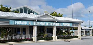
Leonard M. Thompson International Airport, formerly known as The Marsh Harbour International Airport, is an airport serving Marsh Harbour, a town in the Abaco Islands, The Bahamas. Marsh Harbour is a major tourist attraction. The airport offers scheduled passenger flights to Nassau and several destinations in Florida as well as regional jet flights nonstop to three major U.S. hubs, Atlanta, Charlotte and Miami in the U.S. In 2007 a new runway was built to allow larger, regional jets to operate from Marsh Harbour. A new airport terminal opened on 27 May 2014.
Sky Bahamas was an airline based in Nassau, Bahamas.

The following is an alphabetical list of topics related to the Commonwealth of The Bahamas.

Locair was an American FAR Part 135 charter airline with its headquarters in unincorporated Broward County, Florida, near Fort Lauderdale. Formed in 1993, the airline specialized in cargo and passenger charters around Florida and to the Bahamas and Cuba. The airline is unique in that it is an FAA Part 135 On-Demand airline, it has Scheduled Authority for operations in the Bahamas, allowing it to schedule flights and offer online booking, unlike other charter operators in Florida. The carrier has said it will not exceed its operational authority by the United States Department of Transportation and FAA.

The Sea of Abaco, located in The Bahamas, is an approximately 100 kilometres long saltwater lagoon separating Great Abaco Island from a chain of barrier islands known as the Abaco Cays. Depths in the Sea of Abaco are generally a few metres, and shallow reefs and shoals can pose a serious hazard to navigation. Despite these hazards, the sea is popular with boaters and is sometimes referred to as a 'marine highway', offering a sheltered passage through the Abaco Islands. The majority of the largest settlements and towns in the Abaco Islands are located along the shores of the sea.
