
Gladstone is a city located in Clackamas County, Oregon, United States. The population was 11,491 at the 2010 census. Gladstone is an approximately 4-square-mile (10 km2) suburban community, 12 miles (19 km) south of Portland, the largest city in Oregon, and located at the confluence of the Clackamas and Willamette rivers.

Oregon City is the county seat of Clackamas County, Oregon, United States, located on the Willamette River near the southern limits of the Portland metropolitan area. As of the 2020 census, the city population was 37,572. Established in 1829 by the Hudson's Bay Company, in 1844 it became the first U.S. city west of the Rocky Mountains to be incorporated.

Clackamas County is one of the 36 counties in the U.S. state of Oregon. As of the 2020 census, the population was 421,401, making it Oregon's third-most populous county. Its county seat is Oregon City. The county was named after the Native Americans living in the area, the Clackamas people, who are part of the Chinookan peoples.

Johnson City is a city in Clackamas County, Oregon, United States. The population was 566 at the 2010 census. Because of its small area, its population density is over 8,000 per square mile, making it the most densely populated city in Oregon.

Milwaukie is a city mostly in Clackamas County, Oregon, United States; a very small portion of the city extends into Multnomah County. The population was 20,291 at the 2010 census. Founded in 1847 on the banks of the Willamette River, the city, known as the Dogwood City of the West, was incorporated in 1903 and is the birthplace of the Bing cherry. The city is now a suburb of Portland and also adjoins the unincorporated areas of Clackamas and Oak Grove.

The Portland metropolitan area is a metro area in the U.S. states of Oregon and Washington centered on the principal city of Portland, Oregon. The U.S. Office of Management and Budget (OMB) identifies it as the Portland–Vancouver–Hillsboro, OR–WA Metropolitan Statistical Area, a metropolitan statistical area used by the United States Census Bureau (USCB) and other entities. The OMB defines the area as comprising Clackamas, Columbia, Multnomah, Washington, and Yamhill Counties in Oregon, and Clark and Skamania Counties in Washington. The area's population is estimated at 2,753,168 in 2017.

North Clackamas School District (NC12) serves more than 40 square miles and is located 7 miles from downtown Portland. Included are the incorporated cities of Milwaukie, Happy Valley, and Johnson City, parts of Damascus, and the neighborhoods of Oak Grove, Concord, Clackamas, Sunnyside, Mount Scott, Southgate, and Carver. The North Clackamas School District 12 spends $8,053 per pupil in current expenditures. The district spends 59% on instruction, 38% on support services, and 4% on other elementary and secondary expenditures.

Clackamas Town Center is a shopping mall established in 1981 in the Portland, Oregon, metropolitan area, located on unincorporated land in the Clackamas area of Clackamas County, in the U.S. state of Oregon. It is managed and co-owned by Brookfield Properties Retail Group and is currently anchored by JCPenney, Dick's Sporting Goods, Macy's and a separate Macy's Home/Backstage store. It also includes a 20-screen Century movie theater.
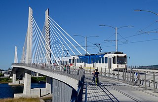
The MAX Orange Line is a light rail service in Portland, Oregon, United States, operated by TriMet as part of the MAX Light Rail system. It connects Portland City Center, Portland State University (PSU), Southeast Portland, Milwaukie, and Oak Grove. The line serves 17 stations from Union Station/Northwest 5th & Glisan to Southeast Park Avenue and runs for 201⁄2 hours daily with a minimum headway of 15 minutes during most of the day. It averaged 3,480 daily weekday riders in September 2020.

Milwaukie High School is a public high school located in Milwaukie, Oregon, United States. It is one of seven high schools within the North Clackamas School District. The school's mascot is the mustang, and its colors are maroon and gold.

Ardenwald-Johnson Creek is a neighborhood straddling the border between Portland and Milwaukie, Oregon. It is recognized by both Portland's Office of Neighborhood Involvement as well as Milwaukie's Neighborhoods Program.
Brentwood-Darlington is a neighborhood on the southern edge of Portland, Oregon, bordering SE 45th Avenue to the west, SE Duke Street to the north, and SE 82nd Avenue to the east. The county line separating Multnomah County from Clackamas County forms most of the neighborhood's southern boundary, though small portions of the neighborhood and the city extend into Clackamas County. Roughly, the southern boundary is SE Harney Drive on the eastern one-fourth, and SE Clatsop Street on the other three-quarters.
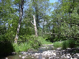
Johnson Creek is a 25-mile (40 km) tributary of the Willamette River in the Portland metropolitan area of the U.S. state of Oregon. Part of the drainage basin of the Columbia River, its catchment consists of 54 square miles (140 km2) of mostly urban land occupied by about 180,000 people as of 2012. Passing through the cities of Gresham, Portland, and Milwaukie, the creek flows generally west from the foothills of the Cascade Range through sediments deposited by glacial floods on a substrate of basalt. Though polluted, it is free-flowing along its main stem and provides habitat for salmon and other migrating fish.
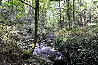
Tryon Creek is a 4.85-mile (7.81 km) tributary of the Willamette River in the U.S. state of Oregon. Part of the drainage basin of the Columbia River, its watershed covers about 6.5 square miles (16.8 km2) in Multnomah and Clackamas counties. The stream flows southeast from the Tualatin Mountains through the Multnomah Village neighborhood of Portland and the Tryon Creek State Natural Area to the Willamette in the city of Lake Oswego. Parks and open spaces cover about 21 percent of the watershed, while single-family homes dominate most of the remainder. The largest of the parks is the state natural area, which straddles the border between the two cities and counties.
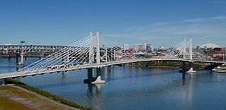
Tilikum Crossing, Bridge of the People is a cable-stayed bridge across the Willamette River in Portland, Oregon, United States. It was designed by TriMet, the Portland metropolitan area's regional transit authority, for its MAX Orange Line light rail passenger trains. The bridge also serves city buses and the Portland Streetcar, as well as bicycles, pedestrians, and emergency vehicles. Private cars and trucks are not permitted on the bridge. It is the first major bridge in the U.S. that was designed to allow access to transit vehicles, cyclists and pedestrians but not cars.
Libraries in Clackamas County (LINCC) is a consortium of the public libraries of Clackamas County, Oregon. It was established in 1977 when the first county-wide funding levy was approved by county voters. LINCC is a resource and revenue sharing network with a single library computer system.
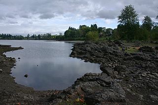
Elk Rock Island is an island on the Willamette River in the U.S. state of Oregon. The 12- to 13-acre island, formed 40 million years ago by a volcano, was given to Portland by Peter Kerr in 1940. The city of Milwaukie took ownership of the park in April 2016. The island is accessible via Spring Park.
Kellogg Creek is a tributary, about 4.5 miles (7.2 km) long, of the Willamette River in the Portland metropolitan area of the U.S. state of Oregon. It begins near Lake Lenore in Johnson City and flows northwest to meet the river at Milwaukie. Kellogg Creek is joined about midway along its course by Mount Scott Creek, its major tributary, which enters the main stem near North Clackamas Central Park.

Southeast Bybee Boulevard is a light rail station in Portland, Oregon, United States, served by TriMet as part of the MAX Light Rail system. It is the 14th station southbound on the Orange Line, which operates between Portland City Center, Southeast Portland, and Milwaukie. The grade-separated, island platform station adjoins Union Pacific Railroad (UP) freight tracks to the east and McLoughlin Boulevard to the west. Its entrances are located on the Bybee Bridge, which spans over the platform and connects Portland's Sellwood-Moreland and Eastmoreland neighborhoods. Nearby places of interest include Westmoreland Park, Eastmoreland Golf Course, Crystal Springs Rhododendron Garden, and Reed College.


