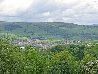
Batley is a market town in the Metropolitan Borough of Kirklees, in West Yorkshire, England. Batley lies south-west of Leeds, north-west of Wakefield and Dewsbury, south-east of Bradford and north-east of Huddersfield. Batley is part of the Heavy Woollen District. In 2011 the population of Batley including Hanging Heaton, Staincliffe, Carlinghow, Birstall, Birstall Smithies, Copley Hill and Howden Clough was 48,730.

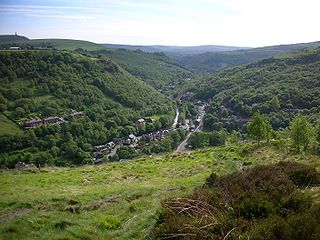
Calderdale is a metropolitan borough of West Yorkshire, England, which had a population of 211,439. It takes its name from the River Calder, and dale, a word for valley. The name Calderdale usually refers to the borough through which the upper river flows, while the actual landform is known as the Calder Valley. Several small valleys contain tributaries of the River Calder. The main towns of the borough are Brighouse, Elland, Halifax, Hebden Bridge, Sowerby Bridge and Todmorden.

The Colne Valley is a steep sided valley on the east flank of the Pennine Hills in the English county of West Yorkshire. It takes its name from the River Colne which rises above the town of Marsden and flows eastward towards Huddersfield.

Winmalee is a town in New South Wales, Australia. Winmalee is located 77 kilometres west of the Sydney CBD, in the local government area of the City of Blue Mountains. At the 2011 census, Winmalee had a population of 6,593.

The Penistone Line is operated by Northern Trains in the West Yorkshire Metro and Travel South Yorkshire areas of northern England. It connects Huddersfield and Sheffield via Penistone and Barnsley, serving many rural communities. Metrocards can be used for travel between Huddersfield and Denby Dale and intermediate stations.

Springwood is a town in the Blue Mountains, New South Wales, Australia. Springwood is located 72 kilometres west of the Sydney CBD in the local government area of the City of Blue Mountains. At the 2021 census, Springwood had a population 8,423 people.

Colne Valley is a constituency represented in the House of Commons of the UK Parliament since 2019 by Jason McCartney of the Conservative Party.

The A635 is a main road that runs between Manchester and Doncaster running east–west through Stalybridge, Saddleworth Moor, Holmfirth, Barnsley and the Dearne Valley. The section forming the eastern part of the Mancunian Way is a motorway and is officially designated as the A635(M) though there is no road sign with this designation, and the signs at the entrance of Mancunian Way westbound show A57(M).

Brough and Shatton is a civil parish in Hope Valley in the High Peak district of Derbyshire, England. It is named for the two hamlets of Brough-on-Noe and Shatton. Brough is about 2 km, or just over 1 mile, west (upstream) of Shatton; both are on the River Noe, a tributary of the upper River Derwent. They lie within the Peak District National Park, about 15 miles west of Sheffield and 30 miles east of Manchester. According to the 2011 census, Brough and Shatton had a combined population of 136. There is a friendly rivalry between the two hamlets, which contest numerous sports competitions throughout the year.

The White Rose Centre is a shopping centre in the Beeston area of Leeds, West Yorkshire, England. It spans two floors and is near the M621 motorway. It takes its name from the White Rose of York, the traditional symbol of Yorkshire. Most shops are situated on the Ground Floor. The Upper Level mezzanine and ‘The Village’ outdoor expansion houses one of two food courts as well some retail outlets, a Cineworld 11-screen cinema, a Starbucks and an al fresco dining terrace boasting new tenants Wagamama, Prezzo, TGI Fridays and Five Guys among others. It also houses an outdoor children’s play area. Although the centre is smaller than other out-of-town shopping centres, it has attracted large retailers such as Next, JD Sports, Zara, River Island and Marks and Spencer.

Marsh is a suburb of Huddersfield, West Yorkshire, England that is situated 0.93 miles (1.5 km) west of the town centre.

Longroyd Bridge is a suburb approximately 1200 yds (1.1 km) to the southwest of Huddersfield town centre, West Yorkshire, England. The area is composed of industrial and commercial units. There is little housing in the commercial area, though within a few hundred yards are the housing areas of Thornton Lodge and Paddock.

Turnbridge is the area to the east of Huddersfield town centre ring road in West Yorkshire, England. It forms a corridor along which passes St Andrews Road, (B6432), and the Huddersfield Broad Canal to Aspley, where the Broad Canal meets Huddersfield Narrow Canal in the Aspley Basin. There are places for a limited number of narrowboat moorings. Some have electric and fresh water services.

Springwood is a suburb in the City of Logan, Queensland, Australia. In the 2021 census, Springwood had a population of 9,710 people.

Waterloo is a suburb of Huddersfield, West Yorkshire, England. It is 2 miles (3.2 km) to the east of Huddersfield Town Centre. It is the part of Dalton named after the former Waterloo public house and consists mostly of housing with a central shopping area made up of independent shops, a large Morrisons Supermarket, and a petrol station located on Penistone Road.

Greenhead Park is an urban park located 0.5 miles (0.8 km) west of the town centre of Huddersfield, West Yorkshire, England. It is one of the largest parks in Huddersfield and was originally opened in 1884. It is an English Heritage grade II listed property and is also in a Conservation Area.

The A640 is a road in England which runs between Rochdale in Greater Manchester and Huddersfield in West Yorkshire.

Morley Tunnel is a railway tunnel in West Yorkshire, England, situated between Morley and Batley railway stations on the Huddersfield line. From its northern end, it extends 3,369 yards (3,081 m), passing beneath Morley town centre, to its southern end.

The River Calder is a river in West Yorkshire, in Northern England.


