
Spurr Township is a civil township of Baraga County in the U.S. state of Michigan. The population was 262 at the 2020 census.

Pickford Township is a civil township of Chippewa County in the U.S. state of Michigan. As of the 2020 census, the township population was 2,791.

The St. Joseph River is an 86.1-mile-long (138.6 km) tributary of the Maumee River in northwestern Ohio and northeastern Indiana in the United States, with headwater tributaries rising in southern Michigan. It drains a primarily rural farming region in the watershed of Lake Erie.

Bear River is a small clear slow-moving river in the U.S. state of Michigan. 14.7 miles (23.7 km) long, it is the largest tributary of Little Traverse Bay in the northwest of the lower peninsula. Traverse Bay is on Lake Michigan. The river is formed as the outflow of Walloon Lake on the boundary between Charlevoix County and Emmet County, draining from the southeast end of the lake at 45°15′40″N84°56′01″W near the community of Walloon Lake in Melrose Township. M-75 has its northern terminus in a junction with US 131 nearby.

There are two streams named Salmon Trout River in the Upper Peninsula of the U.S. state of Michigan.
Carp River is a 40.2-mile-long (64.7 km) river in Chippewa and Mackinac counties in the U.S. state of Michigan. 21.7 miles (34.9 km) of the river were added to the National Wild and Scenic Rivers System in 1992.

The Dowagiac River is a southwesterly flowing 30.9-mile-long (49.7 km) stream in the Lower Peninsula of the U.S. state of Michigan. It is a tributary to the St. Joseph River which flows, in turn, into eastern Lake Michigan.
Paint Creek is a 16.8-mile-long (27.0 km) stream in the U.S. state of Michigan, located in northern Oakland County and rising in Brandon Township in the northern part of the county. The creek drains through a series of lakes that lead into Lake Orion. Paint Creek continues as the outflow from the east end of Lake Orion in downtown Lake Orion. It flows southeastward through Oakland Township and Rochester Hills into the Clinton River in Rochester.
Coldwater River is a 29.5-mile-long (47.5 km) stream in the U.S. state of Michigan. Located in Branch County, the river rises in Ovid Township at 41°50′14″N84°59′13″W as the outflow of Coldwater Lake. Flowing north and west, it is joined by the outflow from the Lake of the Woods and continues north for several miles. West of the city of Coldwater, it flows through a series of lakes: South Lake, Messenger Lake, Cemetery Lake, North Lake, Randall Lake, Morrison Lake, Craig Lake, and Hodunk Pond. It then continues to the northwest and empties into the St. Joseph River in the village of Union City at 42°03′58″N85°07′48″W.

The Coldwater River is a 19.4-mile-long (31.2 km) stream in the U.S. state of Michigan. Located in western Michigan, the river is a part of the Grand River drainage basin.
Cedar Creek may refer to several small streams in the U.S. state of Michigan:
The Mitchigan River is a 14.9-mile-long (24.0 km) stream in the Upper Peninsula of the U.S. state of Michigan. It flows into the Fence River at 46°17′27″N88°09′58″W in northeast Iron County in Mansfield Township. The Fence River is a tributary of the Michigamme River, which is itself a tributary to the Menominee River, flowing to Lake Michigan. The Mitchigan River has its source in the southeast corner of Baraga County at 46°24′58″N88°08′05″W. It flows mostly southward along the boundary between Iron and Marquette counties, crossing briefly into western Marquette County.

The Betsie River is a 54.0-mile-long (86.9 km) river in the U.S. state of Michigan. The river is located in the northwestern Lower Peninsula of the state, flowing into Lake Michigan at Frankfort. The river's course is mostly within Benzie County,, although the river rises in western Grand Traverse County and flows briefly through northern Manistee County.

Boyne River is a stream in Northern Michigan, named for the River Boyne in Leinster, Ireland. Together with the north and south branches, the river system has approximately 22 miles (35 km) of mainstream and the water basin drains 40,320 acres (163.2 km2). Boyne River is Lake Charlevoix's second-largest tributary, after the Jordan River.

The Prairie River is a small river that flows 54 miles (87 km) through Branch and St. Joseph counties in Michigan. The river rises at 41°48′20″N85°00′54″W in northern Kinderhook Township in Branch County, and flows west-northwest into the St. Joseph River at 41°54′45″N85°38′21″W just south of the city of Three Rivers, Michigan.
The Misery River is a 24.2-mile-long (38.9 km) river on the Keweenaw Peninsula of the U.S. state of Michigan.
Sturgeon River is a 63.6-mile-long (102.4 km) river in the U.S. state of Michigan, flowing mostly southward through Alger County and Delta County counties on the Upper Peninsula.
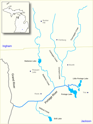
The Portage River is a 15.5-mile-long (24.9 km) river in the U.S. state of Michigan, flowing mostly southwesterly through northeast Jackson County.
Carp River is a 21.9-mile-long (35.2 km) river in Marquette County in the U.S. state of Michigan. The Carp River is formed by the outflow of Deer Lake in Ishpeming Township north of Ishpeming at 46°31′58″N87°40′01″W in the Upper Peninsula.
The Maple River, which flows into Burt Lake, is a major river in the northern tip of the Lower Peninsula of the U.S. state of Michigan. The river drains sections of Cheboygan County and Emmet County, and provides an outflow for the 3,395-acre (1,374 ha) Douglas Lake.
