Spurr Township, Michigan

Last updated

Spurr Township, Michigan
Spurr Township, MI location.png
Location within Baraga County (red) and the administered CDP of Three Lakes (pink)
USA Michigan location map.svg
Red pog.svg
Spurr Township
Location within the state of Michigan
Usa edcp location map.svg
Red pog.svg
Spurr Township
Location within the United States
Coordinates: 46°31′47″N88°12′49″W / 46.52972°N 88.21361°W / 46.52972; -88.21361
CountryUnited States
State Michigan
County Baraga
Established1868
Government
[1]
  SupervisorJason Killoran
   Clerk Jessica Omernick
Area
  Total
159.04 sq mi (411.91 km2)
  Land150.83 sq mi (390.65 km2)
  Water8.21 sq mi (21.26 km2)
Elevation
1,745 ft (532 m)
Population
 (2020)
  Total
262
  Density1.74/sq mi (0.67/km2)
Time zone UTC-5 (Eastern (EST))
  Summer (DST) UTC-4 (EDT)
ZIP code(s)
49861 (Michigamme)
49879 (Republic)
49919 (Covington)
49946 (L'Anse)
Area code 906
FIPS code 26-76000 [2]
GNIS feature ID1627115 [3]
Website Official website

Spurr Township is a civil township of Baraga County in the U.S. state of Michigan. The population was 262 at the 2020 census. [4]

Contents

Communities

History

The township had been organized while it was part of Houghton County. It was one of the four original townships of Baraga County when it was set off from Houghton in 1875. It is named for "Spurr Mountain", the site of an iron ore mine, first named the "Spurr Mountain Mining Company", organized in 1872. Operations ceased in 1878, and then resumed again in 1881 under a reorganized "Spurr Iron Mining Company". [9] A post office named "Spurr Mountain" opened December 30, 1874, and was discontinued December 15, 1887. It was reestablished June 4, 1890, and operated until June 30, 1896. [10]

Geography

According to the United States Census Bureau, the township has a total area of 159.0 square miles (411.9 km2), of which 150.8 square miles (390.6 km2) is land, and 8.2 square miles (21.3 km2) (5.16%) is water. [11]

Demographics

According to the 2020 census, the township had a population of 262. [12]

Related Research Articles

<span class="mw-page-title-main">Baraga County, Michigan</span> County in Michigan, United States

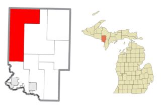
Baraga County is a county in the Upper Peninsula in the U.S. state of Michigan. As of the 2020 census, the population was 8,158, making it Michigan's fifth-least populous county. The county seat is L'Anse. The county is named after Bishop Frederic Baraga, a Catholic missionary who ministered to the Ojibwa Indians in the Michigan Territory.

<span class="mw-page-title-main">Munising Township, Michigan</span> Civil township in Michigan, United States

Munising Township is a civil township of Alger County in the U.S. state of Michigan. As of 2020, its population was 2,865.

<span class="mw-page-title-main">Arvon Township, Michigan</span> Civil township in Michigan, United States

Arvon Township is a civil township of Baraga County in the U.S. state of Michigan. As of the 2020 census, the township population was 492. Despite its name, Mount Arvon, the highest point in Michigan, is located just south of the township, in neighboring L'Anse Township.

<span class="mw-page-title-main">Baraga Township, Michigan</span> Civil township in Michigan, United States

Baraga Township is a civil township of Baraga County in the U.S. state of Michigan. As of the 2020 census, the township population was 3,478. The village of Baraga is located in the southeast corner of the township. Baraga State Park is also located within the township.

<span class="mw-page-title-main">Covington Township, Michigan</span> Civil township in Michigan, United States

Covington Township is a civil township of Baraga County in the U.S. state of Michigan. The population was 375 at the 2020 census.

<span class="mw-page-title-main">L'Anse Township, Michigan</span> Civil township in Michigan, United States

L'Anse Township is a civil township of Baraga County in the U.S. state of Michigan. As of the 2020 census, the township population was 3,551. The township contains Mount Arvon and Mount Curwood, Michigans highest and second-highest points, as well as the village of L'Anse.

<span class="mw-page-title-main">Sagola Township, Michigan</span> Civil township in Michigan, United States

Sagola Township is a civil township of Dickinson County in the U.S. state of Michigan. The population was 1,066 at the 2020 census.

<span class="mw-page-title-main">Elm River Township, Michigan</span> Civil township in Michigan, United States

Elm River Township is a civil township of Houghton County in the U.S. state of Michigan. The population was 204 at the 2020 census.

<span class="mw-page-title-main">Laird Township, Michigan</span> Civil township in Michigan, United States

Laird Township is a civil township of Houghton County in the U.S. state of Michigan. The population was 487 at the 2020 census.

<span class="mw-page-title-main">Iron River Township, Michigan</span> Civil township in Michigan, United States

Iron River Township is a civil township of Iron County in the U.S. state of Michigan. The population was 1,585 at the 2000 census and 1,052 in 2020.

<span class="mw-page-title-main">Stambaugh Township, Michigan</span> Civil township in Michigan, United States

Stambaugh Township is a civil township of Iron County in the U.S. state of Michigan. The population was 1,140 according to the 2010 census, and 1,200 in 2020.

<span class="mw-page-title-main">Michigamme, Michigan</span> Census-designated place & unincorporated community in Michigan, United States

Michigamme is an unincorporated community in Marquette County in the U.S. state of Michigan. It is located within Michigamme Township on the north shores of Lake Michigamme. For statistical purposes, the United States Census Bureau has defined Michigamme as a census-designated place (CDP). The CDP had a population of 255 at the 2020 census.

<span class="mw-page-title-main">Michigamme Township, Michigan</span> Civil township in Michigan, United States

Michigamme Township is a civil township of Marquette County in the U.S. state of Michigan. The population was 327 at the 2020 census. The unincorporated community of Michigamme is located within the township.

<span class="mw-page-title-main">Powell Township, Michigan</span> Civil township in Michigan, United States

Powell Township is a civil township of Marquette County in the U.S. state of Michigan. The population was 732 at the 2020 census, down from 816 in 2010.

<span class="mw-page-title-main">Republic Township, Michigan</span> Civil township in Michigan, United States

Republic Township is a civil township of Marquette County in the U.S. state of Michigan. The population was 994 at the 2020 census. The unincorporated community of Republic is located within the township.

<span class="mw-page-title-main">Three Lakes, Michigan</span> Census-designated place & unincorporated community in Michigan, United States

Three Lakes is an unincorporated community and census-designated place (CDP) in Baraga County in the U.S. state of Michigan. The CDP had a population of 167 at the 2020 census. Three Lakes is located within Spurr Township.

Herman is an unincorporated community in L'Anse Township of Baraga County in the U.S. state of Michigan. It was established in 1901 along a branch of the Duluth, South Shore and Atlantic Railway approximately midway between Nestoria and L'Anse. A post office opened January 13, 1903, and was discontinued on December 5, 1970.

The Mitchigan River is a 14.9-mile-long (24.0 km) stream in the Upper Peninsula of the U.S. state of Michigan. It flows into the Fence River at 46°17′27″N88°09′58″W in northeast Iron County in Mansfield Township. The Fence River is a tributary of the Michigamme River, which is itself a tributary to the Menominee River, flowing to Lake Michigan. The Mitchigan River has its source in the southeast corner of Baraga County at 46°24′58″N88°08′05″W. It flows mostly southward along the boundary between Iron and Marquette counties, crossing briefly into western Marquette County.

<span class="mw-page-title-main">Lake Michigamme</span> Lake in the state of Michigan, United States

Lake Michigamme, one of Michigan's largest lakes, reaches a depth of over 70 feet (21 m). It covers 4,292 acres (17.37 km2) in Marquette and Baraga counties, Michigan. Van Riper State Park provides public access. The vast majority of the lake lies in Marquette County, with only its westernmost part extending into Baraga County.

The Spurr River is a short stream in the Upper Peninsula of the U.S. state of Michigan. It rises from the outflow of Beaufort Lake at 46°32′47″N88°11′14″W and flows 3.9 miles (6.3 km) east-southeast into Lake Michigamme at 46°31′43″N88°07′54″W.

References

  1. Michigan Townships Association (2025). "Spurr Township, Baraga County, Michigan" . Retrieved January 22, 2025.
  2. "U.S. Census website". United States Census Bureau . Retrieved January 31, 2008.
  3. U.S. Geological Survey Geographic Names Information System: Spurr Township, Michigan
  4. "Explore Census Data". data.census.gov. Retrieved August 4, 2023.
  5. U.S. Geological Survey Geographic Names Information System: Nestoria, Michigan
  6. Romig, Walter (1986) [1973]. Michigan Place Names. Detroit, Michigan: Wayne State University Press. ISBN   0-8143-1838-X.
  7. U.S. Geological Survey Geographic Names Information System: Nestoria Post Office (historical)
  8. U.S. Geological Survey Geographic Names Information System: Imperial Heights, Michigan
  9. History of the upper peninsula of Michigan. Western Historical Co. Chicago: Western Historical Co.1883. pg. 203.
  10. U.S. Geological Survey Geographic Names Information System: Spurr Mountain Post Office (historical)
  11. "Geographic Identifiers: 2010 Demographic Profile Data (G001): Spurr township, Baraga County, Michigan". U.S. Census Bureau, American Factfinder. Archived from the original on February 12, 2020. Retrieved December 24, 2013.
  12. "Explore Census Data". data.census.gov. Retrieved August 4, 2023.