Dorset is a ceremonial county in South West England. It is bordered by Somerset to the north-west, Wiltshire to the north and the north-east, Hampshire to the east, the Isle of Wight across the Solent to the south-east, the English Channel to the south, and Devon to the west. The largest settlement is Bournemouth, and the county town is Dorchester.

Bournemouth is a coastal resort town in the Bournemouth, Christchurch and Poole unitary authority area, in the ceremonial county of Dorset, England. The 2021 census built-up area had a population of 196,455, making it the largest town in Dorset.

Poole is a coastal town and seaport on the south coast of England in the Bournemouth, Christchurch and Poole unitary authority area in Dorset, England. The town is 21 miles (34 km) east of Dorchester and adjoins Bournemouth to the east. Since 1 April 2019, the local authority is Bournemouth, Christchurch and Poole Council. The town had an estimated population of 151,500 making it the second-largest town in the ceremonial county of Dorset. Together with Bournemouth and Christchurch, the conurbation has a total population of nearly 400,000.

Broadstone is a suburb and electoral ward of Poole in Dorset, England. It is located three miles from Hamworthy railway station and seven miles from Bournemouth International Airport. The ward had a population of 10,289 at the 2021 census.

The A338 is a major primary route in southern England, that runs from the junction with the A35 at Poole in Dorset to the junction with the A420 at Besselsleigh in Oxfordshire, a distance of 84 miles (135 km).
Winton is a suburb of Bournemouth, in the Bournemouth, Christchurch and Poole district, in the ceremonial county of Dorset, England. It lies approximately 1 mile (1.6 km) north of Bournemouth town centre, along Wimborne Road. Winton is to the east of Wallisdown, Victoria Park and Talbot Woods and south of Moordown.
Uplands School was a co-educational independent school based in the coastal town of Poole, Dorset on the south coast of England. It consisted of a junior school and a senior school. In 2009, the school merged with Wentworth College.
Northbourne is a suburb of Bournemouth, Dorset in England. It is in the north of the town and borders Ensbury Park.

Bournemouth town centre is an area of Bournemouth, Dorset. The town centre is the central business district and is located near the coast between West Cliff and East Cliff.

Bournemouth Town Hall, also known as the Civic Centre and formerly the Mont Dore Hotel, is a municipal facility in Bourne Avenue, Bournemouth, England. The town hall, which is the meeting place of Bournemouth, Christchurch and Poole Council, is a Grade II listed building. The town hall stands opposite Bournemouth Gardens and the Bournemouth War Memorial and is adjacent to St. Andrew's Church, Richmond Hill.

Richmond Hill is an area of Bournemouth, Dorset, England. It is to the north of Bournemouth Town Centre, south of Richmond Park and west of Lansdowne. The area is located around the road of the same name.

St. Andrew's Church is a Grade II* listed historic parish church in Kinson, Bournemouth, Dorset. The church dates from the 13th century.

St Mark's Church is a Victorian Church of England parish church and listed building in Bournemouth, England.

The Norfolk Royale Hotel is a Grade II listed building and 4 star Victorian hotel in Richmond Hill, Bournemouth, Dorset in England. The hotel is one of Bournemouth's most historic buildings and stands behind St. Andrew's Church, Richmond Hill and opposite the Sacred Heart Church.

The Bournemouth Blitz was the heavy bombing of Bournemouth, Hampshire, England from 1940 to 1944, by the Nazi German Luftwaffe during the Second World War.

St Michael's Church is a Grade II* listed Gothic Victorian church in Bournemouth, Dorset, England.

St Alban's Church is a Grade II listed Gothic Revival Anglican church in the Charminster area of Bournemouth, Dorset, England. The church stands across Charminster Road from the Church of the Annunciation.

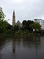
Bournemouth Gardens are Grade II listed gardens in the town of Bournemouth, Dorset, England. Created in the nineteenth century, the gardens follow the towns eponymous River Bourne three kilometres from the historic boundary with Poole south-eastwards into Bournemouth Town Centre.
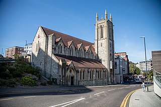
St. Andrew's Church, Exeter Road was a United Reformed Church on Exeter Road in Bournemouth Town Centre. Since May 2013, the building has been occupied by the Halo nightclub.