Richmond Hill, Bournemouth

Last updated

Richmond Hill from above. Bournemouth, looking down on Bourne Avenue and Richmond Hill - geograph.org.uk - 1929924.jpg
Richmond Hill from above.

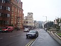
Richmond Hill is an area of Bournemouth, Dorset, England. [1] It is to the north of Bournemouth Town Centre, south of Richmond Park and west of Lansdowne. [2] The area is located around the road of the same name.

Contents

History

In 2018 and 2019, the road was turned into a temporary waterslide in the summer. [3]

In 2023, Vitality will move into the Nationwide building in Richmond Hill. [4]

In 2024, a police investigation was launched into a suspected brothel in the area. [5]

Buildings

Transportation

In 1975, the A338 underpass was built underneath Richmond Hill Roundabout. [8]

The Square is at the bottom of Richmond Hill. [9]

Politics

Richmond Hill is part of the Bournemouth Central ward for elections to the Bournemouth, Christchurch and Poole Council. The same ward elected councillors to Bournemouth Borough Council.

Richmond Hill is also part of the Bournemouth West parliamentary constituency for elections to the House of Commons of the United Kingdom.

Notable people

Related Research Articles

<span class="mw-page-title-main">Dorset</span> County of England

Dorset is a ceremonial county in South West England. It is bordered by Somerset to the north-west, Wiltshire to the north and the north-east, Hampshire to the east, the Isle of Wight across the Solent to the south-east, the English Channel to the south, and Devon to the west. The largest settlement is Bournemouth, and the county town is Dorchester.

<span class="mw-page-title-main">Bournemouth</span> Town in Dorset, England

Bournemouth is a coastal resort town in the Bournemouth, Christchurch and Poole unitary authority area, in the ceremonial county of Dorset, England. The 2021 census built-up area had a population of 196,455, making it the largest town in Dorset.

<span class="mw-page-title-main">A35 road</span> Major road in southern England

The A35 is a major road in southern England, connecting Honiton in Devon and Southampton in Hampshire. It is a trunk road for some of its length. Most of its route passes through Dorset and the New Forest. It originally connected Exeter and Southampton, the original A35 ran along what is now the A3052 joining the present road at Charmouth.

<span class="mw-page-title-main">Sandbanks</span> Human settlement in England

Sandbanks is an affluent neighbourhood of Poole, Dorset, on the south coast of England, situated on a narrow spit of around 1 km2 or 0.39 sq mi extending into the mouth of Poole Harbour.

<span class="mw-page-title-main">Branksome, Dorset</span> Human settlement in England

Branksome is a suburb of Poole, in the Bournemouth, Christchurch and Poole district, in the ceremonial county of Dorset, England. The area consists of residential properties and also a number of commercial and industrial areas.

<span class="mw-page-title-main">A338 road</span> Road in southern England

The A338 is a major primary route in southern England, that runs from the junction with the A35 at Poole in Dorset to the junction with the A420 at Besselsleigh in Oxfordshire, a distance of 84 miles (135 km).

<span class="mw-page-title-main">Holdenhurst</span> Human settlement in England

Holdenhurst is a village in the civil parish of Throop and Holdenhurst, in the Bournemouth, Christchurch and Poole district, in Dorset, England, situated in the green belt land of the north-east suburbs of Bournemouth. The village comprises fewer than 30 dwellings, two farms and the parish church. There are no shops and few local facilities in the village.

<span class="mw-page-title-main">Springbourne</span> Human settlement in England

Springbourne is a suburb of Bournemouth in Dorset, England. It occupies the north-east part of the main built-up area, north of Boscombe. Its formal boundaries are Northcote Road to the west, the Wessex Way (A338) to the north, Ashley Road to the east, and the railway line to the south.

<span class="mw-page-title-main">Transport in Dorset</span>

Dorset is a county in South West England. The county is largely rural and therefore does not have a dense transport network, and is one of the few English counties without a motorway. Owing to its position on the English Channel coast, and its natural sheltered harbours, it has a maritime history, though lack of inland transport routes has led to the decline of its ports.

<span class="mw-page-title-main">Winton, Dorset</span> Suburb of Bournemouth, England

Winton is a suburb of Bournemouth, in the Bournemouth, Christchurch and Poole district, in the ceremonial county of Dorset, England. It lies approximately 1 mile (1.6 km) north of Bournemouth town centre, along Wimborne Road. Winton is to the east of Wallisdown, Victoria Park and Talbot Woods and south of Moordown.

The Bournemouth Daily Echo, commonly known as the Daily Echo, is a local newspaper that covers the area of southeast Dorset, England, including the towns Poole, Bournemouth and Christchurch. Published by Newsquest (Southern) Limited, issues appear Monday to Saturday, and has an average daily circulation of 9,589 in January to June 2020.

<span class="mw-page-title-main">Bournemouth, Christchurch and Poole Council</span> Unitary local authority for the district of Bournemouth, Christchurch and Poole

Bournemouth, Christchurch and Poole Council, which styles itself BCP Council, is the local authority for Bournemouth, Christchurch and Poole, a local government district in the ceremonial county of Dorset, England. The council is a unitary authority, being a district council which also performs the functions of a county council. It is independent from Dorset Council, the unitary authority which administers the rest of the county. The district was created on 1 April 2019 by the merger of the areas that were previously administered by the unitary authorities of Bournemouth and Poole, and the non-metropolitan district of Christchurch.

<span class="mw-page-title-main">Strouden Park</span> Suburb of Bournemouth, England

Strouden Park or Strouden is an area of Bournemouth, Dorset, England.

<span class="mw-page-title-main">Bournemouth town centre</span> Area of Bournemouth, Dorset, England

Bournemouth town centre is an area of Bournemouth, Dorset. The town centre is the central business district and is located near the coast between West Cliff and East Cliff.

<span class="mw-page-title-main">Alder Hills</span> Suburb in Dorset, England

Alder Hills is a suburb in Dorset that crosses the boundaries of Bournemouth and Poole. It is south of Wallisdown, east of Alderney and north of Branksome and Parkstone.

<span class="mw-page-title-main">Bournemouth Town Hall</span> Municipal building in Bournemouth, Dorset, England

Bournemouth Town Hall, also known as the Civic Centre and formerly the Mont Dore Hotel, is a municipal facility in Bourne Avenue, Bournemouth, England. The town hall, which is the meeting place of Bournemouth, Christchurch and Poole Council, is a Grade II listed building. The town hall stands opposite Bournemouth Gardens and the Bournemouth War Memorial and is adjacent to St. Andrew's Church, Richmond Hill.

<span class="mw-page-title-main">Richmond Park, Bournemouth</span> Area of Bournemouth, England

Richmond Park is an area of Bournemouth, Dorset, England. The area is north of Richmond Hill and Springbourne, east of Charminster, west of Queen's Park and south of Winton and Queen's Park.

<span class="mw-page-title-main">St. Andrew's Church, Richmond Hill</span> Grade II listed Gothic Victorian church in Richmond Hill, Bournemouth, Dorset, England

St. Andrew's Church is a Grade II listed Gothic Victorian church in Richmond Hill, Bournemouth, Dorset, England. A United Reformed church, it is noted for being the largest church in the town.

<span class="mw-page-title-main">Bournemouth Blitz</span> German bombing raids on Bournemouth, England during WWII

The Bournemouth Blitz was the heavy bombing of Bournemouth, Hampshire, England from 1940 to 1944, by the Nazi German Luftwaffe during the Second World War.

References

  1. "Richmond Hill". www.bournemouth.gov.uk. Retrieved 21 January 2021.
  2. "FB COMMENTS". bournemouth.streetmapof.co.uk. Retrieved 21 January 2021.
  3. "WATCH: Giant waterslide returns to Bournemouth's Richmond Hill". Bournemouth Echo. Retrieved 21 January 2021.
  4. "Vitality to leave landmark building in Bournemouth due to 'hybrid working'". Bournemouth Echo. Retrieved 17 January 2023.
  5. "Investigation into brothel found in Bournemouth town centre". Bournemouth Echo. 4 May 2024. Retrieved 4 May 2024.
  6. "ECHO OFFICE BUILDING, Bournemouth Christchurch and Poole - 1140113 | Historic England". historicengland.org.uk. Retrieved 22 February 2021.
  7. "History". www.bournemouthurc.org.uk. Retrieved 21 January 2021.
  8. "Picture of the Day: Richmond Hill roundabout in 1975 (when it had trees)". Bournemouth Echo. Retrieved 21 January 2021.
  9. "Picture of the Day: This is what Bournemouth Square looked like in 1976". Bournemouth Echo. Retrieved 21 January 2021.