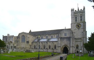
Christchurch is a town and civil parish on the south coast of Dorset, England. The parish had a population of 31,372 in 2021. It adjoins Bournemouth to the west, with the New Forest to the east. Part of the historic county of Hampshire, Christchurch was a borough within the administrative county of Dorset from 1974 until 2019, when it became part of the new Bournemouth, Christchurch and Poole unitary authority.

Chobham Common is a 655.7-hectare (1,620-acre) biological Site of Special Scientific Interest north of Chobham in Surrey. It is a Nature Conservation Review site, Grade I and a national nature reserve. It is part of the Thames Basin Heaths Special Protection Area and the Thursley, Ash, Pirbright and Chobham Special Area of Conservation. It contains three scheduled monuments. Most of the site is managed by the Surrey Wildlife Trust as the Chobham Common nature reserve, but the SSSI also includes a small private reserve managed by the Trust, Gracious Pond.
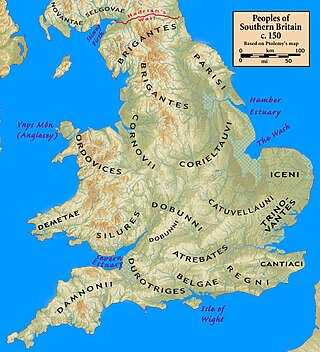
The Durotriges were one of the Celtic tribes living in Britain prior to the Roman invasion. The tribe lived in modern Dorset, south Wiltshire, south Somerset and Devon east of the River Axe and the discovery of an Iron Age hoard in 2009 at Shalfleet, Isle of Wight gives evidence that they may also have lived in the western half of the island. After the Roman conquest, their main civitates, or settlement-centred administrative units, were Durnovaria and Lindinis. Their territory was bordered to the west by the Dumnonii; and to the east by the Belgae.

Hengistbury Head, formerly also called Christchurch Head, is a headland jutting into the English Channel between Bournemouth and Mudeford in the English county of Dorset. It is a site of international importance in terms of its archaeology and is scheduled as an Ancient Monument. Declared a Local Nature Reserve in 1990, the head and its surroundings form part of the Christchurch Harbour Site of Special Scientific Interest. It is also a Special Area of Conservation, Special Protection Area, an Environmentally Sensitive Area and a Site of Nature Conservation Interest. The name "Hengistbury Head" refers to the whole of the headland area; the elevated portion is called Warren Hill.

Christchurch Harbour is a natural harbour in the county of Dorset, on the south coast of England named after the nearby town of Christchurch. Two rivers, the Avon and the Stour, flow into the Harbour at its northwest corner. The harbour is generally shallow and due to the tidal harmonics in the English Channel has a double high water on each tide. On the north side of the harbour, east of the Avon are Priory Marsh, and to the east of this Stanpit Marsh, a Local Nature Reserve. To the west side of the harbour are Wick Fields, the southern flank of the harbour being bounded by Hengistbury Head, a prominent coastal headland. The harbour flows into the Christchurch Bay and the English Channel through a narrow channel known locally as The Run which rests between Mudeford Quay and Mudeford Spit. Shallow-draught boats can enter from this channel and cruise up stream for 2 miles (3 km) choosing either the Avon or the Stour, the Stour leading up as far as Iford Bridge passing Christchurch Quay and Tuckton.

Bickerton Hill refers to two low red sandstone hills that form the southern end of the Mid Cheshire Ridge in Cheshire, north-west England. The high point, Raw Head, lies on the northerly hill and has an elevation of 227 metres. Parts of the southerly hill are also known as Larkton Hill.

Wick is a village on the south bank of the River Stour in Dorset, England, just short of the Stour's entry into Christchurch Harbour. Along with the nearby village of Tuckton, it originally formed a tithing in the Hundred of Christchurch, before becoming part of the Civil Parish of Southbourne in 1894. The latter was incorporated into the Borough of Bournemouth in 1901.
Muir of Dinnet is a national nature reserve (NNR) situated close to the village of Dinnet in Aberdeenshire, Scotland. The reserve extends 1166 hectares from the River Dee to Culbean hill, and encompasses a wide range of habitats including dry heath, raised bog, woodland, and two lochs: Loch Kinord and Loch Davan. Muir of Dinnet was first declared a NNR in 1977 due to its value as a habitat for flora and fauna, and its important geomorphological features, the most striking of which is the Burn O'Vat. Muir of Dinnet is owned by Dinnet Estate and managed by NatureScot, who provide a visitor centre and a range of other facilities including waymarked paths and a car park. As of 2012 it was estimated that approximately 40,000 people visited Muir of Dinnet each year.
Warren Hill may refer to:

Rosenannon Downs is a nature reserve in mid Cornwall, England, UK, being designated Rosenannon Bog and Downs Site of Special Scientific Interest (SSSI), noted for its biological characteristics. The site supports a wide variety of flora and fauna and includes Bronze Age barrows. Conservation work is carried out on the site by the owners, the Cornwall Wildlife Trust.

Woorgreens Lake and Marsh is a 9-hectare (22-acre) nature reserve in Gloucestershire.

Les Landes is an area of coastal heathland in the north-west of Jersey. It has been designated as a Site of Special Interest (SSI) since 1996.

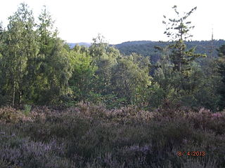
Withybed Wood is a small, yet important patch of woodland located in the lee of Warren Hill, part of Hengistbury Head, Dorset. It is not to be confused with an area of the Wyre Forest in Shropshire, which also has the same name.

The Dorset Heaths form an important area of heathland within the Poole Basin in southern England. Much of the area is protected.

St Catherine's Hill is a 53-metre (174 ft) hill in the borough of Christchurch which, together with Ramsdown and Blackwater hills, forms a ridge between the Avon and Stour valleys. It is a Site of Special Scientific Interest with some areas additionally designated as Special Protection Areas and/or Special Areas of Conservation. The hill provides a range of habitats with both wet and dry heathland, coniferous and broadleaf woodland and scrubland; and is home to some rare flora and fauna including the sand lizard, smooth snake, silver-studded blue butterfly and two types of carnivorous plant.

Talbot Woods is an area of Bournemouth, Dorset. Talbot Woods is south of Talbot Village.

Alder Hills is a suburb in Dorset that crosses the boundaries of Bournemouth and Poole. It is south of Wallisdown, east of Alderney and north of Parkstone.

Fox Hagg is a small nature reserve in the Rivelin Valley area of Sheffield, England. The Allen Sike flows along the north edge of the reserve and the River Rivelin flows through the reserve from Rivelin Dams to the west. The Wyming Brook Nature Reserve borders Fox Hagg to the west. The site is managed by the Wildlife Trust for Sheffield and Rotherham.

East Southbourne and Tuckton is a ward in Bournemouth, Dorset. Since 2019, the ward has elected 2 councillors to Bournemouth, Christchurch and Poole Council.

