Bournemouth Gardens | |
---|---|
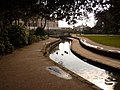
![]() A postcard from the 1910s showing the Upper Gardens. The building in the background is the Mont Dore Hotel, now Bournemouth Town Hall. The tower to the right is St. Andrew's Church. | |
Type | Landscaped garden |
Location | Bournemouth, Dorset, England |
Coordinates | 50°43′2.53″N01°52′33″W / 50.7173694°N 1.87583°W |
Area | 3 kilometres (20.5 hectares) |
Opened | 1840 |
Website | www |
Bournemouth Gardens are Grade II listed gardens in the town of Bournemouth, Dorset, England. Created in the nineteenth century, the gardens follow the towns eponymous River Bourne three kilometres from the historic boundary with Poole south-eastwards into Bournemouth Town Centre.
The Gardens are home to a number of significant Bournemouth landmarks and listed buildings such as; the Town Hall, the War Memorial, St. Andrew's Church and the Pavilion Theatre.
Bournemouth Gardens have been Green Flag Award winners since 1999.
The gardens were planted between 1836 and 1840, with designs made by architects Benjamin Ferrey and Decimus Burton. [1] It wasn't until 1859 that the gardens became publicly accessible.
On 1 May 1908, 7 people were killed and 26 were injured when a tram crashed into the gardens. [2] In 1924-29 the Pavilion Theatre was built in the Lower Central Gardens. [3] In 1970 the Wessex Way flyover (A338) was constructed, cutting through the Upper Central Gardens [4] Collectively known as Upper, Central and Lower Pleasure Gardens, and Coy Pond Gardens, Bournemouth Gardens has constituted as a listed building since 1986 by Historic England. [5]
The COVID-19 pandemic in 2020 reportedly hit the finances of the Gardens Trust. [6]
The gardens begin at Coy Pond. The gardens are bordered by Bourne Valley and Talbot Woods to the north and Branksome Woods and Westbourne to the south.
The Upper Gardens has three distinct continental gardens, European, Asian and North American. The Upper Gardens hold many unusual tree species including a North American Giant Redwood (believed to be the largest in Britain). [7]
The water tower was built between 1883 and 1903, and is currently disused. [8]
The Square separates Central Gardens from the Lower Gardens. Bournemouth War Memorial was built in 1922. [9]
The historic band stand is in the Lower Gardens. [10] The rock garden was built in the 1930s. [11]
The Gardens have an annual Winter Wonderland attraction at Christmas time. [12]
Bournemouth Gardens has a Tennis Centre. [13] The Bournemouth Eye hot air balloon was an attraction until 2016. [14]
Bournemouth is a coastal resort town in the Bournemouth, Christchurch and Poole unitary authority area, in the ceremonial county of Dorset, England. The 2021 census built-up area had a population of 196,455, making it the largest town in Dorset.
Branksome is a suburb of Poole, in the Bournemouth, Christchurch and Poole district, in the ceremonial county of Dorset, England. The area consists of residential properties and also a number of commercial and industrial areas.
Westbourne is a residential and shopping area of Bournemouth, Dorset, England. It is located in between Branksome, Poole and the centre of Bournemouth, just off the A338. Poole Road, mainly full of specialised shops and small cafes, runs through the centre of Westbourne with Seamoor Road curving round bringing more shops and services. Many of the shops have residential property above them.
The A338 is a major primary route in southern England, that runs from the junction with the A35 at Poole in Dorset to the junction with the A420 at Besselsleigh in Oxfordshire, a distance of 84 miles (135 km).
The River Bourne is a small river in Dorset, England. It flows into the English Channel at Bournemouth, taking its name simply from Middle English bourn or burn, a small stream, and giving it to the town at its mouth.
The Square is a public square in Bournemouth Town Centre that marks the centre of Bournemouth, England. The Square separates the Central Gardens from the Lower Gardens.
Springbourne is a suburb of Bournemouth in Dorset, England. It occupies the north-east part of the main built-up area, north of Boscombe. Its formal boundaries are Northcote Road to the west, the Wessex Way (A338) to the north, Ashley Road to the east, and the railway line to the south.
The history of Bournemouth and human settlement in the surrounding area goes back for thousands of years. Bournemouth is a coastal town on the island of Great Britain in Dorset, England, United Kingdom.
Downton is a village and civil parish on the River Avon in southern Wiltshire, England, about 6 miles (10 km) southeast of the city of Salisbury. The parish is on the county boundary with Hampshire and is close to the New Forest; it includes the villages of Wick and Charlton-All-Saints, and the small ancient settlement of Witherington. The Trafalgar Park estate erased the former settlement of Standlynch. The parish church, Trafalgar House, and two more houses are Grade I listed.
The Royal Bournemouth Hospital is an acute general hospital in Bournemouth, Dorset, England. It is managed by the University Hospitals Dorset NHS Foundation Trust. The hospital was managed by The Royal Bournemouth and Christchurch Hospitals NHS Foundation Trust until the merger with Poole Hospital NHS Foundation Trust on 1 October 2020.
Abbotswood is a country house and estate near Lower Swell in Gloucestershire, England. It is a grade II listed building and estate, of medieval origins and with remodelling and garden work to the designs of Sir Edwin Lutyens from 1901 onwards.
Bournemouth War Memorial is a First World War memorial built in 1921, located in the central gardens in Bournemouth, United Kingdom. The memorial is guarded by two stone lions made by WA Hoare. It was designed by Bournemouth's deputy architect Albert Edward Shervey, who copied the two lions from Antonio Canova's lions which guarded the tomb of Pope Clement XIII.
Alder Hills is a suburb in Dorset that crosses the boundaries of Bournemouth and Poole. It is south of Wallisdown, east of Alderney and north of Parkstone.
Bournemouth Town Hall, also known as the Civic Centre and formerly the Mont Dore Hotel, is a municipal facility in Bourne Avenue, Bournemouth, England. The town hall, which is the meeting place of Bournemouth, Christchurch and Poole Council, is a Grade II listed building. The town hall stands opposite Bournemouth Gardens and the Bournemouth War Memorial and is adjacent to St. Andrew's Church, Richmond Hill.
There are many Grade II listed buildings in the county of Dorset. This is a list of them.
Richmond Hill is an area of Bournemouth, Dorset, England. It is to the north of Bournemouth Town Centre, south of Richmond Park and west of Lansdowne. The area is located around the road of the same name.
Thomas Parr (1769–1847) was a member of an extended family of Liverpool merchants, developing his business as an English slave trader who profited from the Atlantic slave trade to establish himself as "‘a merchant of great eminence in Liverpool".
St Mark's Church is a Victorian Church of England parish church and listed building in Bournemouth, England.
The Bournemouth Blitz was the heavy bombing of Bournemouth, Hampshire, England from 1940 to 1944, by the Nazi German Luftwaffe during the Second World War.
The Bourne Valley Viaducts are two Victorian brick railway viaducts in Bournemouth and Poole, England. One bridge is disused while the other carries a section of the South West Main Line from London to Weymouth between Bournemouth railway station and Branksome railway station.