Related Research Articles
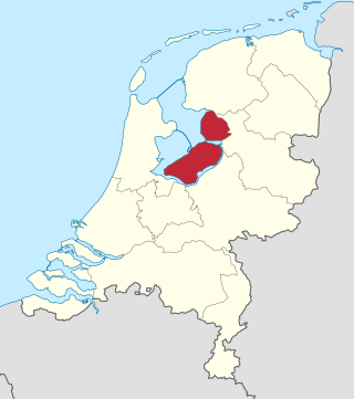
Flevoland is the twelfth and youngest province of the Netherlands, established in 1986, when the southern and eastern Flevopolders, together with the Noordoostpolder, were merged into one provincial entity. It is in the centre of the country in the former Zuiderzee, which was turned into the freshwater IJsselmeer by the closure of the Afsluitdijk in 1932. Almost all of the land belonging to Flevoland was reclaimed in the 1950s and 1960s while splitting the Markermeer and Bordering lakes from the IJsselmeer. As to dry land, it is the smallest province of the Netherlands at 1,412 km2 (545 sq mi), but not gross land as that includes much of the waters of the fresh water lakes (meres) mentioned.

A polder is a low-lying tract of land that forms an artificial hydrological entity, enclosed by embankments known as dikes. The three types of polder are:
- Land reclaimed from a body of water, such as a lake or the seabed
- Flood plains separated from the sea or river by a dike
- Marshes separated from the surrounding water by a dike and subsequently drained; these are also known as koogs, especially in Germany

The Zuiderzee or Zuider Zee was a shallow bay of the North Sea in the northwest of the Netherlands, extending about 100 km inland and at most 50 km wide, with an overall depth of about 4 to 5 metres (13–16 feet) and a coastline of about 300 km. It covered 5,000 km2 (1,900 sq mi). Its name is Dutch for "southern sea", indicating that the name originates in Friesland, to the north of the Zuiderzee. In the 20th century the majority of the Zuiderzee was closed off from the North Sea by the construction of the Afsluitdijk, leaving the mouth of the inlet to become part of the Wadden Sea. The salt water inlet changed into a fresh water lake now called the IJsselmeer after the river that drains into it, and by means of drainage and polders, an area of some 1,500 km2 (580 sq mi) was reclaimed as land. This land eventually became the province of Flevoland, with a population of nearly 400,000 (2011).

The Zuiderzee Works is a man-made system of dams and dikes, land reclamation and water drainage work, in total the largest hydraulic engineering project undertaken by the Netherlands during the twentieth century. The project involved the damming of the Zuiderzee, a large, shallow inlet of the North Sea, and the reclamation of land in the newly enclosed water using polders. Its main purposes are to improve flood protection and create additional land for agriculture.
The Delta Works is a series of construction projects in the southwest of the Netherlands to protect a large area of land around the Rhine–Meuse–Scheldt delta from the sea. Constructed between 1954 and 1997, the works consist of dams, sluices, locks, dykes, levees, and storm surge barriers located in the provinces of South Holland and Zeeland.

het Bildt is a former municipality in the province of Friesland in the northern Netherlands; its capital was Sint Annaparochie. The population was data missing in 2021. On 1 January 2018 it merged with the municipalities of Franekeradeel, Menameradiel and parts of Littenseradiel to form the new municipality Waadhoeke.

Wieringermeer is a former municipality and a polder in the Netherlands, in the province of North Holland. Since 2012 Wieringermeer has been a part of the new municipality of Hollands Kroon.

Zuid-Beveland is part of the province of Zeeland in the Netherlands north of the Western Scheldt and south of the Eastern Scheldt.

Biervliet is a small city in the Dutch province of Zeeland. It is a part of the municipality of Terneuzen, and lies about 16 km South of Vlissingen.

IJzendijke is a city in the municipality of Sluis, about 10 km east of Oostburg, in the Dutch province of Zeeland.

On 17 April 1945, the retreating German occupying forces inundated the polder of Wieringermeer, the Netherlands.

The 1953 North Sea flood was a major flood caused by a heavy storm surge that struck the Netherlands, north-west Belgium, England and Scotland. Most sea defences facing the surge were overwhelmed, resulting in extensive flooding.
The All Saints' Flood of 1570 occurred on November 1–2, 1570, and is considered the worst North Sea flood disaster before the 20th century. It flooded the entire coast of the Netherlands and East Frisia. The effects were felt from Calais in Flanders to Jutland and even Norway. Even though the alleged casualty figures were mostly based on rough estimates and should be viewed with skepticism, up to 25,000 deaths can be assumed.

The St. Elizabeth's flood of 1421 was a flooding of the Grote Hollandse Waard, an area in what is now the Netherlands. It takes its name from the feast day of Saint Elisabeth of Hungary which was formerly 19 November. It ranks 20th on the list of worst floods in history. During the night of 18/19 November 1421 a heavy storm near the North Sea coast caused the dikes to break in a number of places and the lower-lying polder land was flooded. A number of villages were swallowed by the flood and were lost, causing between 2,000 and 10,000 casualties. The dike breaks and floods caused widespread devastation in Zeeland and Holland.
A levee breach or levee failure is a situation where a levee fails or is intentionally breached, causing the previously contained water to flood the land behind the levee.

The Burchardi flood was a storm tide that struck the North Sea coast of North Frisia and Dithmarschen on the night between 11 and 12 October 1634. Overrunning dikes, it shattered the coastline and caused thousands of deaths and catastrophic material damage. Much of the island of Strand washed away, forming the islands Nordstrand, Pellworm and several halligen.

Flood control is an important issue for the Netherlands, as due to its low elevation, approximately two thirds of its area is vulnerable to flooding, while the country is densely populated. Natural sand dunes and constructed dikes, dams, and floodgates provide defense against storm surges from the sea. River dikes prevent flooding from water flowing into the country by the major rivers Rhine and Meuse, while a complicated system of drainage ditches, canals, and pumping stations keep the low-lying parts dry for habitation and agriculture. Water control boards are the independent local government bodies responsible for maintaining this system.

St. Peter's flood refers to two separate storm tides that struck the coasts of Netherlands and Northern Germany in 1651. During the first storm tide, on 22 February, the East Frisian island of Juist was split in two. During the second disaster, on 4–5 March, the city of Amsterdam was flooded.

Saeftinghe Castle was a castle on the northeast tip of the drowned land of Saeftinghe. It was destroyed by flooding in the 16th century, and now its exact location is unknown.

The period between the Capture of Brielle and the Pacification of Ghent was an early stage of the Eighty Years' War between the Spanish Empire and groups of rebels in the Habsburg Netherlands.
References
- ↑ "St. Elizabeth floods". Deltawerken. Archived from the original on 27 March 2016. Retrieved 29 January 2006.
- ↑ "Nethlands Timeline". worldatlas. Retrieved 10 August 2011.
- ↑ Humlum, Ole. "1404: First St. Elizabeth flood in northwest Europe". Climate4you.com. Retrieved 10 August 2011.
| | This article about a flood is a stub. You can help Wikipedia by expanding it. |
| | This Dutch-history-related article is a stub. You can help Wikipedia by expanding it. |