
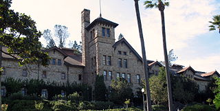
Sutter's Fort was a 19th-century agricultural and trade colony in the Mexican Alta California province. Established in 1839, the site of the fort was originally called New Helvetia by its builder John Sutter, though construction of the fort proper would not begin until 1841. The fort was the first non-indigenous community in the California Central Valley. The fort is famous for its association with the Donner Party, the California Gold Rush, and the formation of the city of Sacramento, surrounding the fort. It is notable for its proximity to the end of the California Trail and Siskiyou Trails, which it served as a waystation.

The National Road was the first major improved highway in the United States built by the federal government. Built between 1811 and 1837, the 620-mile (1,000 km) road connected the Potomac and Ohio Rivers and was a main transport path to the West for thousands of settlers. When improved in the 1830s, it became the second U.S. road surfaced with the macadam process pioneered by Scotsman John Loudon McAdam.

U.S. Route 66 or U.S. Highway 66 was one of the original highways in the United States Numbered Highway System. It was established on November 11, 1926, with road signs erected the following year. The highway, which became one of the most famous roads in the United States, ran from Chicago, Illinois, through Missouri, Kansas, Oklahoma, Texas, New Mexico, and Arizona before terminating in Santa Monica in Los Angeles County, California, covering a total of 2,448 miles (3,940 km).
St. Helena is a city in Napa County, California, United States. Located in the North Bay region of the San Francisco Bay Area, the population was 5,438 at the 2020 census.

Stovepipe Wells is a way-station in the northern part of Death Valley, in unincorporated Inyo County, California.

Bale Grist Mill State Historic Park is a California state park located in Napa County between St. Helena and Calistoga. The park is the site of a water-powered grist mill that was built in 1846 is one of only two water-driven mills remaining west of the Mississippi River.

The Santa Fe Trail was a 19th-century route through central North America that connected Franklin, Missouri, with Santa Fe, New Mexico. Pioneered in 1821 by William Becknell, who departed from the Boonslick region along the Missouri River, the trail served as a vital commercial highway until 1880, when the railroad arrived in Santa Fe. Santa Fe was near the end of El Camino Real de Tierra Adentro which carried trade from Mexico City. The trail was later incorporated into parts of the National Old Trails Road and U.S. Route 66.

State Route 29 is a state highway in the U.S. state of California that travels from Interstate 80 in Vallejo north to State Route 20 in Upper Lake. It serves as the primary road through the Napa Valley, providing access to the Lake County region to the north and the rest of the San Francisco Bay Area to the south.

State Route 88 (SR 88), also known as the Carson Pass Highway, is a state highway in the U.S. state of California. It travels in an east–west direction from Stockton, in the San Joaquin Valley, to the Nevada state line, where it becomes Nevada State Route 88, eventually terminating at U.S. Route 395 (US 395). The highway is so named as it crests the Sierra Nevada at Carson Pass. The highway corridor predates the era of the automobile; the path over Carson pass was previously used for the California Trail and the Mormon Emigrant Trail. The mountainous portion of the route is included in the State Scenic Highway System.
Beckwourth Pass is the lowest mountain pass in the Sierra Nevada mountain range at an elevation of 5,221 feet (1,591 m).

Buildings, sites, districts, and objects in California listed on the National Register of Historic Places:

Robert Louis Stevenson State Park is a California state park, located in Sonoma, Lake and Napa counties. The park offers a 5-mile (8 km) hike to the summit of Mount Saint Helena from which much of the Bay Area can be seen. On clear days it is possible to see the peak of Mount Shasta, 192 miles (310 km) distant.

Traveler's Rest was a stopping point of the Lewis and Clark Expedition, located about one mile south of Lolo, Montana. The expedition stopped from September 9 to September 11, 1805, before crossing the Bitterroot Mountains, and again on the return trip from June 30 to July 3, 1806. Traveler's Rest is at the eastern end of the Lolo Trail. It was declared a National Historic Landmark in 1960 and added to the National Register of Historic Places in 1966. The boundaries were subsequently revised, and mostly lie within the 51-acre (21 ha) Traveler's Rest State Park, which is operated by the Montana Fish, Wildlife & Parks. Significant archeological findings made in 2002, including latrine sites with traces of mercury and fire hearths, make this the only site on the Lewis and Clark National Historic Trail that has yielded physical proof of the explorers' presence. Records made by Lewis and Clark often spell "Traveler's" as "Traveller's". This spot is largely unchanged from the days of Lewis and Clark. From this location, Lewis and Clark split up to explore Montana during their return trip, not reuniting until they reached Sanish, North Dakota.

Santa Susana Pass State Historic Park is a California State Park of 670.68 acres (2.7141 km2) located in the city of Los Angeles, in Los Angeles County on the boundary between Ventura and Los Angeles counties, between the communities of Chatsworth and Simi Valley. Geologically, the park is located where the Simi Hills meet the Santa Susana Mountains. Here in the western part of the Transverse Ranges, the land is dominated by high, narrow ridges and deep canyons covered with an abundant variety of plant life. The park offers panoramic views of the rugged natural landscape as a striking contrast to the developed communities nearby. The park is also rich in archaeological, historical, and cultural significance.

The Nobles Emigrant Trail, also known as the Fort Kearney, South Pass and Honey Lake Wagon Road, is a trail in California that was used by emigrant parties from the east as a shortened route to northern California. It was pioneered in 1851 by William Nobles, who discovered an easy shortcut between the Applegate Trail in Nevada and the Lassen Trail in California. The trail was extensively used until the 1870s, when it was superseded by railroads.

Desert Spring is a former settlement in Kern County, California in the Fremont Valley, south of Red Rock Canyon State Park. It was located 1.5 miles (2.4 km) northeast of Cantil.
Lavers' Crossing is a former settlement in Kern County, California. It was located 1 mile (1.6 km) west-northwest of Glennville, at the current junction of White River and Jack Ranch roads.

The Santa Fe And Salt Lake Trail Monument was designated a California Historic Landmark (No.576) on May 17, 1957. Santa Fe And Salt Lake Trail Monument marks the place two Historic trail merged in Cajon Pass in San Bernardino County, California. The Old Spanish Trail and the Mohave Trail-Mojave Road merged in Cajon Pass. The large white marker is just off the Interstate 15 in Cajon Pass, was U.S. Route 66 in the past. It was built by the Pioneer Society of San Bernardino to remember and honor the pioneers that came west. The marker is 12 feet tall and 7 feet square at the base. Cajon Pass was home to the Serrano Indian, Native Californians that lived in the nearby Atongaibit village, in what is now Hesperia.

The Daley Toll Road Monument was designated a California Historic Landmark (No.579) on May 17, 1957. Daley Toll Road Monument marker is in the San Bernardino Mountains. The Monument is on the first wagon road built in San Bernardino Mountains. Engineer Edward Daley Sr. and his sons built and opened the toll road in 1870. They Daley family ran the toll road till 1890. The toll road ran from the city of San Bernardino to Lake Arrowhead. The road was called the Twin and City Creek Turnpike and the turnpike into the mountains. In 1890 the road became a San Bernardino County, California road called the Daley Canyon Road. The road is now a US Forest Service fire road and is closed to the public. The Monument is near the current city of Rimforest, California on California State Route 18 at Daley Canyon Rd, about 0.6 miles East of Rim Forest. The road made good money for Daley family. The road was used by lumber men, cattle men and sheep herders. Edward Daley became a San Bernardino county supervisor from January 5, 1880, to January 8, 1883. He opened a farm ranch called Dell Rosa at the entrance to the toll road. Edward Daley in Council Bluffs, Iowa, married in 1846, Nancy Ann Hunt, daughter of Capt. Jefferson Hunt. Hunt made three trips over the Cajon Pass and Mojave Desert one in 1847, second in 1849 and last in 1851. Each trip he was the leader of wagon trains, bringing pioneer west, down one of the westward Expansion Trails. Edward and Nancy came to California on the 1849 trip, together they had 11 children: Laomi, Celia, Edward Jr., Charles Jefferson, John, Grace, Annetta, Frank, Lou, May and Kate. The road he built went up Strawberry Creek, crossed over to the west fork of City Creek, passed by the east of Strawberry Peak and then dropped into Little Bear Valley. Little Bear Valley is where the towns of Blue Jay and Lake Arrowhead are located. At the end of the toll road John Commerford ran the top end of the toll road. John Commerford ran a store at the location.

The Big Bar, also called Upper Bar, is a gold mine in Jackson, California, United States. The mine opened in 1848 along the Mokelumne River and is registered as California Historical Landmark #41.
