Saint Margaret, St. Margarets, or St. Margaret's may refer to:

St Margarets is an affluent suburb and neighbourhood in the London Borough of Richmond upon Thames, about 9 miles (14 km) west-southwest of central London. It is bounded by the Thames Tideway to the north-east, and the River Crane to the north-west and north where the land tapers between those rivers. Land and buildings closer to Richmond Bridge than the eponymous railway station are, traditionally distinctly, known as East Twickenham. Both places go by their post town and traditional parish, Twickenham quite often; in the 19th century the south of St Margarets was marked on maps as Twickenham Park.

St Margarets railway station is on the Hertford East branch line off the West Anglia Main Line in the east of England, serving the villages of Stanstead St Margarets and Stanstead Abbotts, Hertfordshire. It is 20 miles 25 chains (32.7 km) down the line from London Liverpool Street and is situated between Rye House and Ware. Its three-letter station code is SMT. It is in the civil parish of Great Amwell.
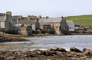
St Margaret's Hope is a village in the Orkney Islands, off the north coast of Scotland. It is known locally as The Hope or The Hup. With a population of about 550, it is Orkney's third largest settlement after Kirkwall and Stromness.

Stoke Golding is a village and civil parish in the Hinckley and Bosworth district of Leicestershire, England, close to the county border with Warwickshire. According to the 2001 census, the total population was 1,721 in just over 700 houses. The population at the 2011 census was 1,684 in 723 households. The village is 15 miles (24 km) from the city of Leicester, about 3 miles (4.8 km) northwest of Hinckley and 4.5 miles (7.2 km) northeast of Nuneaton. The village is bordered on one side by the Ashby Canal, well-used for recreational purposes.

Bucknall is a village and civil parish in the East Lindsey district of Lincolnshire, England. The village is situated approximately 5 miles (8 km) west from Horncastle and 5 miles (8 km) north from Woodhall Spa.

Bygrave is a village and civil parish in the North Hertfordshire district of Hertfordshire, England, about 2 miles north-east of Baldock. In the 10th century the parish was called Bigraffan and 11th to 16th centuries Bigrave. According to the 2011 census it had a population of 306. A reservoir is situated behind the Old Rectory and used for irrigation of potato crops by Manor Farm.
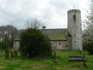
Ilketshall St Margaret is a village and civil parish in the north of the English county of Suffolk. It is 3 miles (4.8 km) south of the market town of Bungay in the East Suffolk district. The parish is part of the area known as the Saints and had a population of 160 at the 2011 United Kingdom census.

Streatley is a village and civil parish in the Central Bedfordshire district of Bedfordshire, England.
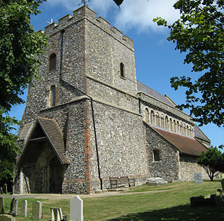
St. Margaret's at Cliffe is a three-part village situated just off the coast road between Deal and Dover in Kent, England. The centre of the village is about ¾ mile (1 km) from the sea, with the residential area of Nelson Park further inland, and St Margaret's Bay situated along and below the cliffs north of South Foreland. The parish church, dedicated to St Margaret of Antioch, is a Grade I listed building.

Stanstead Abbotts is a village and civil parish in the district of East Hertfordshire, Hertfordshire, England; it lies on the county boundary with Essex. At the 2001 census, the parish had a population of 1,983.

Stanstead St Margarets, often abbreviated to just St Margarets, is a village and civil parish in the district of East Hertfordshire, Hertfordshire, England. It is located halfway between the towns of Hoddesdon and Ware. The village is separated from the village of Stanstead Abbotts by the River Lea, and had a population of 1,318 at the census of 2001, increasing to 1,652 at the 2011 Census.
Flixton is a village and civil parish located in the north of the English county of Suffolk. It is around 2 miles (3.2 km) south-west of Bungay in the East Suffolk district and is one of the villages around Bungay which make up the area known as The Saints. The A143 road runs just to the north of the parish border linking Bungay with Harleston and Diss.

Shottisham is a village and civil parish in the East Suffolk district, in the county of Suffolk. It lies in the Wilford Hundred, about four and a half miles south-east of Woodbridge, between the parishes of Sutton, Alderton, Ramsholt and Hollesley, in the Bawdsey peninsula. About three miles from the coast at Hollesley Bay and Shingle Street, the village street overlooks a slight hollow of meads and copses at the road crossing of Shottisham Creek, a tributary brook of the river Deben.
Linstead Parva is a small village and civil parish in the East Suffolk district of Suffolk in eastern England. It has a small but notable 13th-century parish church, still in regular use. The village pub, The Greyhound, was already established and trading when referenced in 1874, but it closed permanently in March 1955, and is now a private dwelling.

Thimbleby is a village and civil parish in the East Lindsey district of Lincolnshire, England. It is situated approximately 1 mile (1.6 km) west from the A158 road and the town of Horncastle.

Langton is a village and civil parish in the East Lindsey district of Lincolnshire, England. It is 1.5 miles (2.4 km) west of the town of Horncastle.

St Cross South Elmham is a village and civil parish in the north of the English county of Suffolk. It is in the East Suffolk district, close to the border with Norfolk and is 3 miles (4.8 km) east of Harleston and 4.25 miles (6.84 km) south-west of Bungay. It is one of the villages around Bungay known as the Saints.

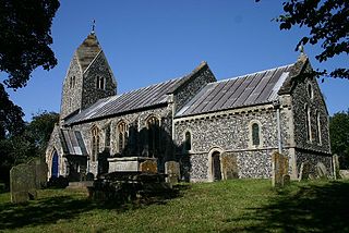
St Margaret South Elmham is a village and civil parish in the north of the English county of Suffolk. It is 4 miles (6.4 km) south-west of the market town of Bungay in the East Suffolk district. It is one of the parishes surrounding Bungay which are known as The Saints.
