
Ethete is a census-designated place (CDP) in Fremont County, Wyoming, United States. The population was 1,553 at the 2010 census. The town is located on the Wind River Indian Reservation. It grew up around the Episcopal St. Michael's Mission.

Fort Washakie is a census-designated place (CDP) in Fremont County, Wyoming, United States, within the Wind River Indian Reservation and along U.S. Route 287. The population was 1,759 at the 2010 census. The headquarters for the Eastern Shoshone Tribe is located in Fort Washakie, as well as the Bureau of Indian Affairs agency for the Wind River Indian Reservation.

Lander is a city in Wyoming, United States, and the county seat of Fremont County. It is in central Wyoming, along the Middle Fork of the Popo Agie River, just south of the Wind River Indian Reservation. It is a tourism center with several nearby guest ranches. Its population was 7,487 at the 2010 census.

Fort Bridger was originally a 19th-century fur trading outpost established in 1842, on Blacks Fork of the Green River, in what is now Uinta County, Wyoming, United States. It became a vital resupply point for wagon trains on the Oregon Trail, California Trail, and Mormon Trail. The Army established a military post here in 1858 during the Utah War, until it was finally closed in 1890. A small town, Fort Bridger, Wyoming, remains near the fort and takes its name from it.

Washakie was a prominent leader of the Shoshone people during the mid-19th century. He was first mentioned in 1840 in the written record of the American fur trapper, Osborne Russell. In 1851, at the urging of trapper Jim Bridger, Washakie led a band of Shoshones to the council meetings of the Treaty of Fort Laramie. Essentially from that time until his death, he was considered the head of the Eastern Shoshones by the representatives of the United States government. In 1979, he was inducted into the Hall of Great Westerners of the National Cowboy & Western Heritage Museum.

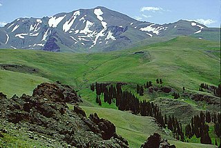
The Wind River Indian Reservation, in the west-central portion of the U.S. state of Wyoming, is shared by two Native American tribes, the Eastern Shoshone and the Northern Arapaho. Roughly 60 mi (97 km) east to west by 50 mi (80 km) north to south, the Indian reservation is located in the Wind River Basin, and includes portions of the Wind River Range, Owl Creek Mountains, and Absaroka Range.
Shoshone National Forest is the first federally protected National Forest in the United States and covers nearly 2,500,000 acres (1,000,000 ha) in the state of Wyoming. Originally a part of the Yellowstone Timberland Reserve, the forest is managed by the United States Forest Service and was created by an act of Congress and signed into law by U.S. President Benjamin Harrison in 1891. Shoshone National Forest is one of the first nationally protected land areas anywhere. Native Americans have lived in the region for at least 10,000 years, and when the region was first explored by European adventurers, forestlands were occupied by several different tribes. Never heavily settled or exploited, the forest has retained most of its wildness. Shoshone National Forest is a part of the Greater Yellowstone Ecosystem, a nearly unbroken expanse of federally protected lands encompassing an estimated 20,000,000 acres (8,100,000 ha).

Fort Washakie was a U.S. Army fort in what is now the U.S. state of Wyoming. The fort was established in 1869 and named Camp Augur after General Christopher C. Augur, commander of the Department of the Platte. In 1870 the camp was renamed Camp Brown in honor of Captain Frederick H. Brown, who was killed in the Fetterman Massacre in 1866.

Sacagawea was a Lemhi Shoshone woman who, in her teens, helped the Lewis and Clark Expedition in achieving their chartered mission objectives by exploring the Louisiana Territory. Sacagawea traveled with the expedition thousands of miles from North Dakota to the Pacific Ocean, helping to establish cultural contacts with Native American people and contributing to the expedition's knowledge of natural history in different regions.

St. John's Episcopal Church and Rectory form a complex of log structures in Jackson, Wyoming. The rectory was built first: in 1911 it was a hostel and community center under the supervision of Episcopal Bishop Nathaniel Thomas. Church services were held there until 1916, when the church was built. The church and hostel are among the largest log structures in Jackson Hole.

The Chapel of the Transfiguration is a small log chapel in Grand Teton National Park, in the community of Moose. The chapel was sited and built to frame a view of the Cathedral Group of peaks in a large window behind the altar. The chapel, which was built in 1925, is owned and operated by St. John's Episcopal Church in Jackson.

The Anderson Lodge or Anderson Studio was built in 1890 in the Absaroka Mountains west of Meeteetse, Wyoming, in what was then the Yellowstone Park Timber Land Reserve, soon renamed the Yellowstone Forest Reserve. The two-story rustic log structure became the home of rancher and artist Abraham Archibald Anderson from 1901 to 1905. Anderson played a significant role in the development of the forest reserve as Special Superintendent of Forest Reserves, and the Anderson Lodge was used as an administrative building for the forest.
The Red Star Lodge and Sawmill, also known as the Shoshone Lodge, is a dude ranch in Shoshone National Forest near the east entrance to Yellowstone National Park. Built between 1924 and 1950, the ranch includes a rustic log lodge surrounded by cabins and support buildings. What is now called the Shoshone Lodge is the most intact example of a dude ranch operation in the area.
The Bates Battlefield was the scene of an 1874 action in which an Arapaho encampment was attacked by U.S. Army forces under Captain Alfred E. Bates. The battlefield is a narrow valley in Hot Springs County, Wyoming near the junction of the Big Horn Mountains and the Owl Creek Mountains. Variously called the Bates Battle, the Battle of Young's Point, the Battle of Snake Mountain and the Nowood Battle, the action was part of a campaign by forces under the command of Lieutenant General Philip Sheridan to protect the comparatively sedentary Shoshone under Chief Washakie from raids by their traditional enemies, the Northern Cheyenne, the Sioux and the Northern Arapaho.
The J.D. Woodruff Cabin Site is the location of the first European-American settlement in the Big Horn Basin of Wyoming. John Dwight Woodruff built a cabin on Owl Creek in Hot Springs County in 1871. Woodruff had befriended Chief Washakie of the Shoshone people and gained Washakie's permission to graze six thousand sheep in the area, one of the first large sheep operations in Wyoming. He ran cattle in the area during the 1880s.

Shoshone-Episcopal Mission is a historic mission and school in Fort Washakie, Wyoming. The school was built from 1889 to 1890 by Rev. John Roberts, the minister and teacher on the Wind River Indian Reservation. Roberts built the boarding school to teach the Shoshone girls living on the reservation; as many of the students lived up to 20 miles (32 km) away from the school, it was necessary to build a boarding school to teach them. The school later became the headquarters of the entire Episcopal mission on the reservation.

John Roberts was a Welsh Anglican priest, writer and missionary in the Bahamas and Wyoming.

St. John the Evangelist Roman Catholic Church, also known as the Church of St. John in the Woods, is a historic church building located near Welches, Oregon and originally located near Zigzag, Oregon. It was built as a mission church and chapel of ease of the parish of St. Aloysius in Estacada. It became a mission of the parish of St. Michael the Archangel in Sandy, Oregon when the latter was established in 1952.
The CM Ranch and Simpson Lake Cabins are separate components of a single historic district associated with Charles Cornell Moore, a Fremont County, Wyoming dude ranch operator. The CM ranch, named after Moore, operated as a dude ranch from 1920 to 1942 and resumed operating in 1945. The Simpson Lake Cabins were purchased by Moore in 1931 and were operated as a hunting camp, continuing until 1997 when the CM ranch was sold to new owners and the Simpson Lake property was taken over by the U.S. Forest Service.. The sites are separated by 13 miles (21 km).
T Cross Ranch is a dude ranch in Fremont County, Wyoming. The ranch is located at 7,800 feet (2,400 m) altitude in Shoshone National Forest, 15 miles (24 km) from Dubois and 2 miles (3.2 km) from the Washakie Wilderness. Apart from a cabin built by the site's original homesteader, the contributing buildings of the ranch date between 1916 and 1946. The ranch was established in 1918 by German immigrant Henry Seipt when he established his homestead and called it The Hermitage. Seipt and his family ran the ranch as a hunting and fishing camp until 1929, when it was sold to Robert and Helen Cox. The Coxes renamed it the T Cross Ranch and made it into a dude ranch. The new name was derived from the Tau Chapter of Saint Anthony's Society, to which Robert Cox had belonged at the Massachusetts Institute of Technology, and from the cross of St. Anthony. A total of 16 log buildings comprise the historic section of the ranch. The district also includes irrigation ditches dug during the 1920s and 1930s.


