
Loyola Marymount University (LMU) is a private Jesuit and Marymount research university in Los Angeles, California. It is located on the west side of the city near Playa Vista. LMU is the parent school to Loyola Law School. LMU offers 55 major and 59 minor undergraduate degrees and programs across six undergraduate colleges. The Graduate Division offers 47 master's degree programs, one education doctorate, one doctorate in juridical science, a Juris Doctor and 13 credential programs. LMU's sports teams are called the Lions and compete at the NCAA Division I level as members of the West Coast Conference in 20 sports.

Huell Burnley Howser was an American television personality, actor, producer, writer, singer, and voice artist, best known for hosting, producing, and writing California's Gold and his human interest show Visiting... with Huell Howser, produced by KCET in Los Angeles for California PBS stations. The archive of his video chronicles offers an enhanced understanding of the history, culture, and people of California. He also voiced the Backson in Winnie the Pooh (2011).

Olvera Street, commonly known by its Spanish name Calle Olvera, is a historic pedestrian street in El Pueblo de Los Ángeles, the historic center of Los Angeles. The street is located off of the Plaza de Los Ángeles, the oldest plaza in California, which served as the center of the city life through the Spanish and Mexican eras into the early American era, following the Conquest of California.

The Jewelry District is a section of Downtown Los Angeles where a variety of jeweled products are sold.
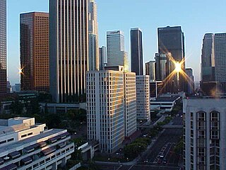
The Financial District is the central business district of Los Angeles It is bounded by the Harbor Freeway to the west, First Street to the north, Main and Hill Streets to the east, and Olympic Boulevard and 9th Street to the south. It is south of the Bunker Hill district, west of the Historic Core, north of South Park and east of the Harbor Freeway and Central City West. Like Bunker Hill, the Financial District is home to corporate office skyscrapers, hotels and related services as well as banks, law firms, and real estate companies. However, unlike Bunker Hill which was razed and now consists of buildings constructed since the 1960s, it contains large buildings from the early 20th century, particularly along Seventh Street, once the city's upscale shopping street; the area also attracts visitors as the 7th and Flower area is at the center of the regional Metro rail system and is replete with restaurants, bars, and shopping at two urban malls.

The Eastern Columbia Building, also known as the Eastern Columbia Lofts, is a thirteen-story Art Deco building designed by Claud Beelman located at 849 S. Broadway in the Broadway Theater District of Downtown Los Angeles. It opened on September 12, 1930, after just nine months of construction. It was built at a cost of $1.25 million as the new headquarters and 39th store for the Eastern-Columbia Department Store, whose component Eastern and Columbia stores were founded by Adolph Sieroty and family. At the time of construction, the City of Los Angeles enforced a height limit of 150 feet (46 m), however the decorative clock tower was granted an exemption, allowing the clock a total height of 264 feet (80 m). J. V. McNeil Company was the general contractor.

Pío Pico State Historic Park is the site of El Ranchito, also known as the Pío Pico Adobe or Pío Pico Mansion, the final home of Pío Pico, the last Governor of Alta California under Mexican rule and a pivotal figure in early California history. Located in Whittier, California, at 6003 Pioneer Blvd. near Whittier Blvd. and Interstate 605, it is California Historical Landmark No. 127, listed as "Casa de Governor Pío Pico". Just west of the park is the San Gabriel River. Across the river is the city that bears his name—Pico Rivera. The park consists of the adobe and about three acres of surrounding land.
Los Angeles Street, originally known as Calle de los Negros is a major thoroughfare in Downtown Los Angeles, California, dating back to the origins of the city as the Pueblo de Los Ángeles.

The historic Subway Terminal, now Metro 417, opened in 1925 at 417 South Hill Street near Pershing Square, in the core of Los Angeles as the second, main train station of the Pacific Electric Railway; it served passengers boarding trains for the west and north of Southern California through a mile-long shortcut under Bunker Hill popularly called the "Hollywood Subway," but officially known as the Belmont Tunnel. The station served alongside the Pacific Electric Building at 6th & Main, which opened in 1905 to serve lines to the south and east. The Subway Terminal was designed by Schultze and Weaver in an Italian Renaissance Revival style, and the station itself lay underground below offices of the upper floors, since repurposed into the Metro 417 luxury apartments. When the underground Red Line was built, the new Pershing Square station was cut north under Hill Street alongside the Terminal building, divided from the Subway's east end by just a retaining wall. At its peak in the 20th century, the Subway Terminal served upwards of 20 million passengers a year.
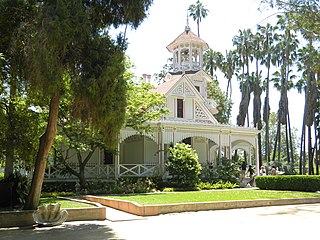
Queen Anne Cottage and Coach Barn is a Victorian style pair of buildings at Baldwin Lake, on the grounds of the Los Angeles County Arboretum and Botanic Garden, located in Arcadia and the San Gabriel Valley of southern California.

El Pueblo de Los Ángeles Historical Monument, also known as Los Angeles Plaza Historic District and formerly known as El Pueblo de Los Ángeles State Historic Park, is a historic district taking in the oldest section of Los Angeles, known for many years as El Pueblo de Nuestra Señora la Reina de los Ángeles del Río de Porciúncula. The district, centered on the old plaza, was the city's center under Spanish (1781–1821), Mexican (1821–1847), and United States rule through most of the 19th century. The 44-acre park area was designated a state historic monument in 1953 and listed on the National Register of Historic Places in 1972.
The Biscuit Company Lofts is a 7-story building in Los Angeles, California. Built in 1925 as a factory, the building was converted to live/work lofts in 2006.
Main Street is a major north–south thoroughfare in Los Angeles, California. It serves as the east–west postal divider for the city and the county as well.

Hill Street is a major north–south thoroughfare in Los Angeles, measuring 4.8 miles (7.7 km) in length. It starts on Martin Luther King, Jr. Boulevard near the campus of USC, and passes north through Downtown Los Angeles, past such landmarks as Pershing Square, the Subway Terminal Building, Angels Flight, Fort Moore and Chinatown. Hill Street merges with the Arroyo Seco Parkway near Dodger Stadium.

Clifton's Cafeteria, once part of a chain of eight Clifton's restaurants, was the oldest surviving cafeteria-style eatery in Los Angeles and the largest public cafeteria in the world when it closed in 2018. Founded in 1931 by Clifford Clinton, the design of the restaurants included exotic decor and facades that were "kitschy and theatrical", and would eventually include multi-story fake redwood trees, stuffed lions, neon plants, and a petrified wood bar. Some considered Clifton's as a precursor to the first tiki bars. The name was created by combining "Clifford" and "Clinton" to produce "Clifton's".

Pershing Square is a small public park in Downtown Los Angeles, California, one square block in size, bounded by 5th Street to the north, 6th Street to the south, Hill Street to the east, and Olive Street to the west. Originally dedicated in 1866 by Mayor Cristóbal Aguilar as La Plaza Abaja, the square has had numerous names over the years until it was finally dedicated in honor of General John J. Pershing in 1918.
The late-Victorian-era Downtown of Los Angeles in 1880 was centered at the southern end of the Los Angeles Plaza area, and over the next two decades, it extended south and west along Main Street, Spring Street, and Broadway towards Third Street. Most of the 19th-century buildings no longer exist, surviving only in the Plaza area or south of Second Street. The rest were demolished to make way for the Civic Center district with City Hall, numerous courthouses, and other municipal, county, state and federal buildings, and Times Mirror Square. This article covers that area, between the Plaza, 3rd St., Los Angeles St., and Broadway, during the period 1880 through the period of demolition (1920s–1950s).
The Lugo Adobe also called the Vicente Lugo Adobe or Casa de Don Vicente Lugo was a house in the city of Los Angeles, located on the east side of the Los Angeles Plaza at 512–524 N. Los Angeles Street.
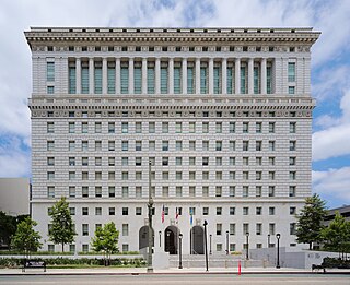
The Hall of Justice in Los Angeles is located at 211 W. Temple Street in the Civic Center district of Downtown Los Angeles. It occupies the southern two-thirds of the block between Temple and First streets and between Broadway and Spring streets.


.jpg)