Related Research Articles

Klemtu is an unincorporated community on Swindle Island in the coastal fjords of British Columbia, Canada. It is located on Kitasoo Indian Reserve No. 1.
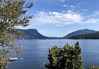
Loughborough Inlet is one of the lesser principal inlets of the British Columbia Coast. It penetrates the Coast Mountains on the north side of the Discovery Islands archipelago, running about 35 km (22 mi) from its head at the mouth of the Stafford River to Chancellor Channel and Cordero Channel, which are on the north side of West Thurlow Island. A further 14 km (8.7 mi) west along Chancellor Channel is Johnstone Strait.
Garden Bay Marine Provincial Park is a provincial park in British Columbia, Canada at the northwest end of the Sechelt Peninsula on the lower Sunshine Coast, near the community of Madeira Park. Established in 1969, it contains approximately 163 ha.

Harmony Islands Marine Provincial Park is a provincial park in British Columbia, Canada, located on the east side of Hotham Sound, which is a side-inlet of the lower reaches of Jervis Inlet, on that inlet's north side roughly opposite the mouth of Sechelt Inlet.

Saltery Bay Provincial Park is a provincial park in British Columbia, Canada, located southeast of the city of Powell River, and on the north side of the entrance to Jervis Inlet in the central area of that province's Sunshine Coast region.
Honeymoon Bay is an unincorporated community in the Canadian province of British Columbia. It is located on Cowichan Lake in the southeastern part of Vancouver Island — approximately 75 kilometres (47 mi) northwest of Victoria — at 48°49′N124°10′W. In 2011, its population was listed at 580.
Maple Bay is a seaside community located in the Cowichan Valley of southern Vancouver Island, British Columbia, Canada. A narrow inlet and surrounded by smooth, pebbled beaches, Maple Bay is home to marine activity all year round. Maple Bay is a small town with a population of 2,640.
Kingcome, also known as Okwunalis or Ukwana'lis is an unincorporated settlement in the Kingcome Inlet area of the Central Coast of British Columbia, Canada, located a few miles up the Kingcome River from the head of the inlet. Quaee Indian Reserve No. 7 is the Indian reserve containing the village.
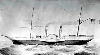
The Labouchere was a paddle steamer in the service of the Hudson's Bay Company, built in 1858 at Green's in Blackwall, London, England. Under the command of Captain J. Trivett it was mostly in service in British Columbia and the rest of the Pacific Northwest in the 1850s and 1860s, including the Stikine lisière in Russian America. In 1859, its then-captain John Swanson was elected by a "celebrated" majority of one in the colonial riding of Nanaimo for the Legislative Assembly of the Colony of Vancouver Island.
Roy was a cannery town on the South Coast of British Columbia, Canada, located on Loughborough Inlet north of the town of Campbell River and the Discovery Islands.
Bliss Landing, formerly Bishop Landing or Bishops Landing, was a cannery town on the South Coast of British Columbia, Canada, located on the northwest side of the Malaspina Peninsula on the upper Sunshine Coast, north of the town of Lund and across the mouth of Desolation Sound from Cortes Bay and Manson's Landing on Cortes Island.
Vancouver Bay was a cannery town on the South Coast of British Columbia, Canada, located on the East side of Prince of Wales Reach of lower Jervis Inlet, at the bay of the same name, which is the mouth of the Vancouver River.
Vancouver River is located in the Sunshine Coast region of the South Coast of British Columbia, Canada, emptying into Prince of Wales Reach of lower Jervis Inlet at the former cannery town of Vancouver Bay and the bay of the same name. The river is approximately 21 km in length.
Boswell was a cannery town in the Central Coast region of the South Coast of British Columbia, Canada, located on the north side of Boswell Inlet, an arm of Smith Sound.
Forward Harbour was a cannery town in the Johnstone Strait region of the Central Coast of British Columbia, Canada, located on the inlet of the same name, which is on the mainland side of Wellbore Channel, to the east of Hardwicke Island. Nearby on the same vicinity on the Mainland, though fronting on other bodies of water, are Jackson Bay to the immediate north, off Sunderland Channel, and Heydon Bay, British Columbia to the east on Loughborough Inlet.
Malaspina Strait is a strait in the northern Gulf of Georgia-Sunshine Coast region of British Columbia, Canada. It separates Texada Island from the upper Sunshine Coast-Malaspina Peninsula area on the adjacent mainland.
Musket Island Marine Provincial Park is a provincial park in British Columbia, Canada, located on the west side of Nelson Island, at the mouth of Jervis Inlet and near Earl's Cove in the Sunshine Coast region.
Dorman Island is an island in the Johnstone Strait region of the Central Coast of British Columbia, Canada, between West and East Cracroft Islands on the north side of the isthmus that joins them at low tide. Until 1940, with Farquharson Island, it was one of a group called the Double Islands; they were renamed to avoid duplication of the name elsewhere.
Kildonan is an unincorporated community in the Alberni Inlet-Barkley Sound region of the west coast of southern Vancouver Island, British Columbia. The former steamboat landing and ferry dock is on the east shore of Uchuchklesit Inlet, which branches northwest of the lower reaches of Alberni Inlet. Adjacent to Pacific Rim National Park Reserve, the locality is by road and ferry about 120 kilometres (75 mi) southwest of Port Alberni.
References
| | This Canadian ghost town-related article is a stub. You can help Wikipedia by expanding it. |
| | This article about a location on the South Coast of British Columbia, Canada is a stub. You can help Wikipedia by expanding it. |