
Pewsey is a large village and civil parish at the centre of the Vale of Pewsey in Wiltshire, about 6 miles (10 km) south of Marlborough and 71 miles (114 km) west of London. It is within reach of the M4 motorway and the A303 and is served by Pewsey railway station on the Reading to Taunton line.
All Cannings is a village and civil parish in the Vale of Pewsey in the English county of Wiltshire, about 4 miles (6 km) east of Devizes. The parish includes the nearby smaller settlement of Allington.

Alton is a civil parish in Wiltshire, England. The parish includes the adjacent villages of Alton Barnes and Alton Priors, and the nearby hamlet of Honeystreet on the Kennet and Avon Canal. It lies in the Vale of Pewsey about 6 miles (10 km) east of Devizes.

Beechingstoke is a small village and civil parish in Wiltshire, England. It lies in the Vale of Pewsey about 5 miles (8 km) west of Pewsey and the same distance east of Devizes. The parish includes the hamlet of Broad Street and the northern part of the village of Bottlesford.

Easton Royal is a village in the civil parish of Easton in Wiltshire, England, about 3 miles (5 km) east of Pewsey and 5 miles (8 km) south of Marlborough. The village was the location of Easton Priory from 1234 to 1536. The village mistakenly gained the Royal suffix in 1838 and the name Easton Royal has been in general use since the 1850s.

Grafton is a civil parish in Wiltshire, England, in the Vale of Pewsey about 7 miles (11 km) southeast of Marlborough. Its main settlement is the village of East Grafton, on the A338 Burbage - Hungerford road; the parish includes the village of Wilton and the hamlets of West Grafton, Marten and Wexcombe.

Huish is a small village and former civil parish in Wiltshire, England, 2 miles (3.2 km) northwest of Pewsey and 4 miles (6.4 km) southwest of Marlborough. It is on the south-facing edge of the Marlborough Downs, where the downs adjoin the Vale of Pewsey.

Wilsford is a small village and civil parish in the Vale of Pewsey in the English county of Wiltshire, about 4 miles (6 km) southwest of Pewsey.

Alvediston is a small village and civil parish in Wiltshire, England, about 7 miles (11 km) east of Shaftesbury and 11 miles (18 km) southwest of Salisbury. The area is the source of the River Ebble and is within the Cranborne Chase and West Wiltshire Downs Area of Outstanding Natural Beauty.
Bemerton, once a rural hamlet and later a civil parish to the west of Salisbury, Wiltshire, England, is now a suburb of that city. Modern-day Bemerton has areas known as Bemerton Heath, Bemerton Village and Lower Bemerton.

Milton Lilbourne is a village and civil parish in the county of Wiltshire, England, in the Vale of Pewsey between Pewsey and Burbage. It is largely a mixed residential area centred on the Manor. The nearest town is Marlborough, 5.5 miles (8.9 km) to the north.

Upavon is a rural village and civil parish in the county of Wiltshire, England. As its name suggests, it is on the upper portion of the River Avon which runs from north to south through the village. It is on the north edge of Salisbury Plain about 4 miles (6.4 km) south of Pewsey, 10 miles (16 km) southeast of the market town of Devizes, and 20 miles (32 km) north of the cathedral city of Salisbury. The A345 and A342 roads run through the village.

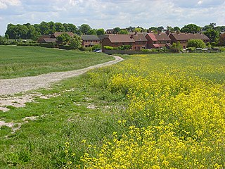
Woodborough is a small village and civil parish in the Vale of Pewsey, Wiltshire, England, about 3.5 miles (5.6 km) west of Pewsey.

Wootton Rivers is a small village and civil parish in the Vale of Pewsey, Wiltshire, England. The village lies about 3 miles (5 km) northeast of Pewsey and 4 miles (6 km) south of Marlborough. During the 20th century its population halved and most of its facilities closed.

Manningford is a civil parish in Wiltshire, England. The parish includes the villages of Manningford Abbots, Manningford Bohune and Manningford Bruce, and the hamlet of Manningford Bohune Common, together known as the Manningfords.

Marden is a small village and civil parish 6 miles (9.7 km) southeast of Devizes in the county of Wiltshire, south west England. The parish is in the Vale of Pewsey which carries the upper section of the Salisbury Avon; to the south the parish extends into Salisbury Plain.

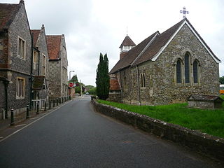
All Saints Church in Alton Priors, Wiltshire, England, dates from the 12th century. It is recorded in the National Heritage List for England as a designated Grade II* listed building, and is now in the care of The Churches Conservation Trust. It was declared redundant on 28 July 1972, and was vested in the Trust on 12 December 1973.

Wilcot is a village in Wiltshire, England, in the Vale of Pewsey about 6 miles (10 km) southwest of Marlborough and 1.5 mi (2.4 km) northwest of Pewsey.

Boscombe is a small village in the civil parish of Allington, Wiltshire, England. It lies about 3 miles (5 km) southeast of Amesbury on the banks of the River Bourne, on the A338 road which follows the Bourne on its way from Salisbury to Tidworth and beyond.

The Church of St Laurence is the main Church of England parish church for the village of Downton, Wiltshire, England. An unusually long building for a village church, the present structure dates from 1147. Continually altered and enlarged until the mid-19th century, the church displays every style of architecture from the Norman to Victorian eras, and has been designated a Grade I listed building.


